Toggle navigation
LMEC Home
Exhibitions
Georeferencing
Tools for Teachers
Collections
My Favorites
Sign Up / Log In
Search
Search the map portal
Map Collection
Map Collection
Map Sets
Search
Search
Search for
Search In
All Fields
Creator
Title
Subject
Place
Search All Digital Collections
Advanced Search
26 Results
My Search
Start Over
More Like
commonwealth:z603vq284
Remove constraint More Like: commonwealth:z603vq284
Filter your Search
Place
North and Central America
26
New York
25
United States
25
Manhattan
5
Long Island
3
New Jersey
3
Brooklyn (borough)
2
Crown Point
2
more
Place
»
Topic
Long Island, Battle of, New York, N.Y., 1776--Maps
8
New York (N.Y.)--Maps
6
New York Metropolitan Area--Maps
5
United States--History--Revolution, 1775-1783--Maps
5
Manhattan (New York, N.Y.)--Maps
4
New York (State)--Maps--Early works to 1800
4
New York Harbor (N.Y. and N.J.)--Maps
4
Long Island (N.Y.)--Maps
3
more
Topic
»
Date
Date range begin
–
Date range end
Current results range from
1733
to
1890
View distribution
Creator
Kitchin, Thomas, 1719-1784
3
Amherst, Jeffery Amherst, Baron, 1717-1797
2
Andrews, Peter, active 1765-1782
2
Dripps, M. (Matthew)
2
Dury, Andrew
2
Faden, William, 1749-1836
2
Montrésor, John, 1736-1799
2
A. Fullarton & Co.
1
more
Creator
»
Format
Maps/Atlases
26
Manuscripts
1
Georeferenced
Yes
2
No
24
Collection
American Revolutionary War-Era Maps
16
New York Public Library Collection
14
Urban Maps
6
Norman B. Leventhal Map & Education Center Collection
5
William L. Clements Library Collection
5
MacLean Collection Map Library
2
Maritime Charts and Atlases
2
Available to use
Creative Commons license
14
No known restrictions
5
Search Constraints
Sort by relevance
relevance
title
date (asc)
date (desc)
Number of results to display per page
20 per page
10
per page
20
per page
50
per page
100
per page
View results as:
grid view
map view
Search Results
1.
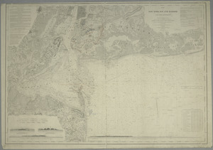
Map of New-York Bay and Harbor and the environs : [with colored manuscript additions to show positions of troops and fleets at...
2.
Driving road chart of the country surrounding New York City : embracing the counties (or portions thereof) of New York, Kings,...
3.
Map of the cities of New York, Brooklyn & Jersey City
4.
Map of the cities of New York, Brooklyn, Jersey City, Hudson City and Hoboken
5.
Principal cities of the United States
6.
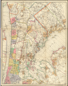
Topographical map of the City and County of New-York, and the adjacent country : with views in the border of the principal...
7.
British troop dispositions in and near New York City, July and August 1781
8.
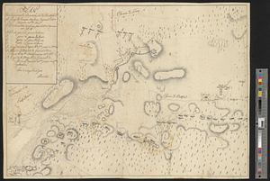
Plan des environs de Brookland &c a Bettford : levé à coup d'oeil
9.
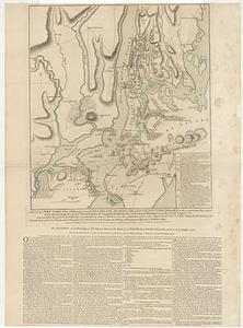
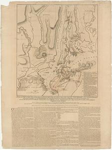
A plan of New York Island, with part of Long Island, Staten Island & east New Jersey, with a particular description of the...
10.
A plan of New York Island, with part of Long Island, Staten Island & east New Jersey, with a particular description of the...
11.
The seat of action, between the British and American forces or an authentic plan of the western part of Long Island, with the...
12.
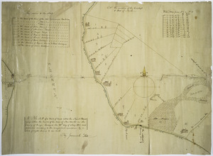
Sketch of the country illustrating the late engagement in Long Island
13.
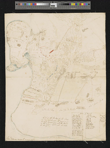
Sketch of the position of the army on Long Island upon the morning of the 26th of August, 1776; with the march on the ensuing...
14.
Map of a tract of land called the Nyack Patent lying within the limits of the town of New Utrecht in the County of Kings
15.
A map of the eastern part of the province of New York with part of New Jersey, & c
16.
A map of the eastern part of the province of New York with part of New Jersey, & c
17.
Map of the progress of His Majesty's armies in New York, during the late campaign : illustrating the accounts published in the...
18.
A map of the Province of New York, with part of Pensilvania, and New England : from an actual survey by Captain Montresor,...
19.
A map of the Province of New York, with part of Pensilvania, and New England : from an actual survey by Captain Montresor,...
20.
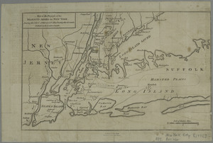
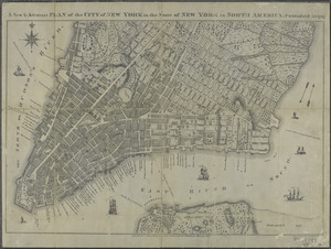
A new & accurate plan of the city of New York in the state of New York in North America
‹ Prev
Next ›
1
2