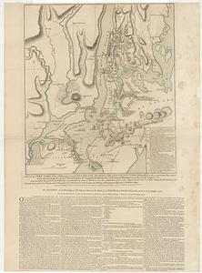
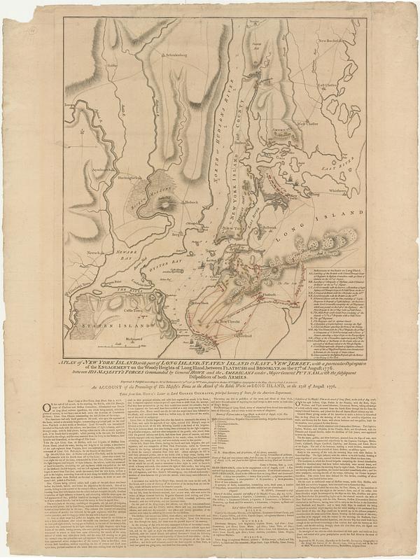
A plan of New York Island, with part of Long Island, Staten Island & east New Jersey, with a particular description of the engagement on the Woody Heights of Long Island, between Flatbush and Brooklyn, on the 27.th of August 1776 between His Majesty's forces commanded by General Howe and the Americans under Major General Putnam, with the subsequent disposition of both the armies
This map is also available in American Revolutionary Geographies Online (ARGO), a collections portal especially built for material relating to the American Revolutionary War Era. Visit ARGO to learn more about this item and explore the historical geography of North America in the late eighteenth century.
Item Information
- Title:
- A plan of New York Island, with part of Long Island, Staten Island & east New Jersey, with a particular description of the engagement on the Woody Heights of Long Island, between Flatbush and Brooklyn, on the 27.th of August 1776 between His Majesty's forces commanded by General Howe and the Americans under Major General Putnam, with the subsequent disposition of both the armies
- Title (alt.):
-
Account of the proceedings of His Majesty's forces at the attack of the rebel works on Long Island, on the 27th of August 1776, taken from Gen. Howe's letter to Lord George Germaine, principal secretary of state for the American department
- Cartographer:
- Faden, William, 1749-1836
- Publisher:
- Faden, William, 1749-1836
- Name on Item:
-
by W.m Faden, successor to the late M.r T.s Jefferys, geographer to the king, Charing Cross
- Date:
-
October 1776
- Format:
-
Maps/Atlases
- Location:
- MacLean Collection Map Library
- Collection (local):
-
MacLean Collection Map Library
- Subjects:
-
Long Island, Battle of, New York, N.Y., 1776--Maps
New York (State)--History--Revolution, 1775-1783--Maps
New Jersey--History--Revolution, 1775-1783--Maps
- Places:
-
New YorkNew York
- Extent:
- 1 map ; 472 x 421 mm with text 761 x 432 mm
- Terms of Use:
-
Public Domain/No known restrictions on use. Contact host institution to download image.
Contact host institution for more information.
- Publisher:
-
London :
W.m Faden
- Language:
-
English
- Identifier:
-
MC_639
- Call #:
-
639