Toggle navigation
LMEC Home
Exhibitions
Georeferencing
Tools for Teachers
Collections
My Favorites
Sign Up / Log In
Search
Search the map portal
Map Collection
Map Collection
Map Sets
Search
Search
Search for
Search In
All Fields
Creator
Title
Subject
Place
Search All Digital Collections
Advanced Search
154 Results
My Search
Start Over
More Like
commonwealth:z603vm97x
Remove constraint More Like: commonwealth:z603vm97x
Filter your Search
Place
North and Central America
128
United States
71
Canada
22
Saint Lawrence River
11
San Juan
8
Florida
7
Mississippi
7
Quebec
7
more
Place
»
Topic
Manuscript maps--Early works to 1800
138
Nautical charts--Saint Lawrence River--Early works to 1800
8
Saint Lawrence River Valley--Maps--Early works to 1800
7
Saint Lawrence River--Maps--Early works to 1800
7
Añasco (P.R.)--Maps--Early works to 1800
6
Coasts--Florida--Maps--Early works to 1800
6
Coasts--Puerto Rico--Añasco--Maps--Early works to 1800
6
Coasts--Puerto Rico--Mayagüez--Maps--Early works to 1800
6
more
Topic
»
Date
Date range begin
–
Date range end
Current results range from
1613
to
1899
View distribution
Creator
Dumont de Montigny
14
Adlum, John, 1759-1836
9
Bingham, William, 1752-1804
9
Des Barres, Joseph F. W. (Joseph Frederick Wallet), 1722-1824
5
De Brahm, John Gerar William, 1717-approximately 1799
4
Jefferys, Thomas, -1771
4
Norman, John, 1748?-1817
4
Real Escuela de Navegación (Cádiz, Spain)
4
more
Creator
»
Format
Maps/Atlases
154
Manuscripts
139
Georeferenced
Yes
2
No
152
Collection
American Revolutionary War-Era Maps
142
Library of Congress Collection
97
Newberry Library Collection
39
Maritime Charts and Atlases
25
Norman B. Leventhal Map Center Collection
16
Urban Maps
8
Boston and New England Maps
4
Harvard Map Collection
1
more
Collection
»
Available to use
Creative Commons license
100
No known restrictions
15
Search Constraints
Sort by title
relevance
title
date (asc)
date (desc)
Number of results to display per page
50 per page
10
per page
20
per page
50
per page
100
per page
View results as:
grid view
map view
Search Results
1.
1. Prise de Newport par d'Estaing, 1778 : 2. Embossage de Ternay à Newport, 1780
2.
20 tracts, Charleston
3.
Amerique Septentrionale : Acadie ou Nouvelle Ecosse aux anglois : Annapolis Royal
4.
Armstrong County
5.
Barbadoes
6.
[Bay of Seven Islands]
7.
Boston & harbour
8.
Boston Harbor, Massachusetts
9.
[Boston Harbour, with the surroundings, &c]
10.
Boston, its environs and harbour : with the rebels works raised against that town in 1775
11.
Boston, S. West part : No. 25
12.
Campement de l'armée à Tombecbe
13.
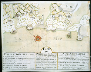
[Campement] de l'armée franc̦oise [devant u]n village des ennemis, les Chicachas le 26 [de mais] 1736
14.
Cantonment of His Majesty's forces in N. America : according to the disposition now made & to be compleated as soon as...
15.
Cantonment of the forces in North America 11th. Octr. 1765
16.
Carta esférica de la canal entre Puerto Rico y Santo Domingo
17.
Carta esférica de la Ysla de la Granada
18.
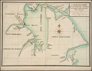
Carte angloise de la Baye de Hudson ou la compagnie apellee Hudson Bay fait son commerce : tirée de la liasse des concecions...
19.
Carte de la campagne de la division aux ordres du Mis. de St. Simon en Virginie depuis le 2 7bre. 1781 jusq-a la reddition...
20.
Carte de la coste de la Louisiane, depuis la Baye de St. Bernard jusqu'a celle de Saint Joseph : ou tous les ports, rades, et...
21.
Carte de la rivire du Cannada, la Terre Nevf, Cape Britton et la cotte de Lacadie
22.
Carte de l'entrée du port et rade de Pensacola
23.
Carte du Cap Franc̨ois de Saint Domingue, de l'isle de Cuba, de la Jamaique avec le canal de Bahama, l'entrée du fleuve St....
24.
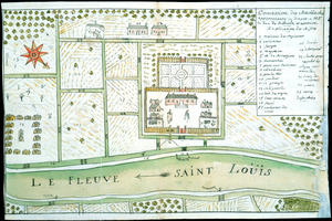
Carte du Fort Rozalie des Natches franc̦ois avec ses dependances et village des sauvages
25.
Carte du Pouldu avec ses environs et la côte de la mer : ou on y voit la disposition de nos batteries, et corps de garde, avec...
26.
Carte d'un partie de l'Amerique Septentrionale : ou est tracée notre route d'Halifax à New York, par Quebec, Montreal, le Lac...
27.
Carte geographique de la Nouvelle Franse
28.
Cawanesque
29.
[Chart of the coast of Quebec from the Riviere St. Jean to Grand Hermine Bay]
30.
[Chart of the gulf and river of St. Lawrence]
31.
Chart of the sea coast from latitude 27⁰00ʹ00ʺ to 27⁰20ʹ00ʺ, with Little Inlet & River into Hillsborough River ; Chart of the...
32.
Chart of the sea coast from lattde. 26⁰20ʹ00ʺ to 26⁰ & 40ʹ00ʺ with the head of Sharkshead River ; Chart of New Inlet ; Chart of...
33.
A chart of the Streights of Bell Isle
34.
Chart of the Streights of Belle Isle
35.
Chart of the streights of Belle Isle
36.
Chart of the streights of Belle Isle
37.
Combat naval à la hauteur de la Baye de Chézapeake [sic] le 5 7bre. 1781
38.
Concession des Chaoüachas appartenante cy devant a Mgr. le duc de Belleisle et associez
39.
[Continuation of Plan du detroit de Belle Isle et du Golphe St. Laurent]
40.
Copia, del mapa de las Indias Occidentales : y del manifiesto que presentò D. Thomas Southuel, à la Superioridad, en el año...
41.
Copy of a map presented to the Congres [sic]
42.
Costa desde la Mobila asta la Bahía de Sn. Josef
43.
Cours de l'Ohio depuis sa source jusqu'a sa jonction avec la Riviere d'Ouabache et les pais voisons
44.
Cuba, ciudad capittal de la ysla del mismo nombre y su famoso puerto sittuado en la costa del sur de gra. ysla, los 20 grados y...
45.
Descripción ychonográfica de la ciudad, puerto y bahía de Santiago de Cuba situado en 20⁰6ʹ de latitud norte y en longd. de...
46.
Dotted line map of Washington, D.C., 1791, before Aug. 19th
47.
Draft of roads in New Jersey
48.
A draught of Lake George, and part of Hudson's River taken September 1756
49.
An exact chart of the river St. Laurence, from Fort Frontenac to the island of Anticosti shewing the soundings, rocks, shoals...
50.
An exact chart of the river St. Laurence, from Fort Frontenac to the island of Anticosti shewing the soundings, rocks, shoals...
‹ Prev
Next ›
1
2
3
4


![[Bay of Seven Islands]](https://bpldcassets.blob.core.windows.net/derivatives/images/commonwealth:7h149v48t/image_thumbnail_300.jpg)


![[Boston Harbour, with the surroundings, &c]](https://bpldcassets.blob.core.windows.net/derivatives/images/commonwealth:t722hs94d/image_thumbnail_300.jpg)


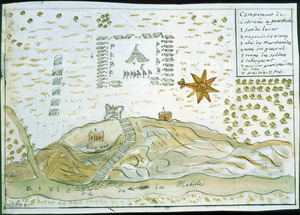
![[Campement] de l'armée franc̦oise [devant u]n village des ennemis, les Chicachas le 26 [de mais] 1736](https://bpldcassets.blob.core.windows.net/derivatives/images/commonwealth:z603vn65v/image_thumbnail_300.jpg)


![[Chart of the coast of Quebec from the Riviere St. Jean to Grand Hermine Bay]](https://bpldcassets.blob.core.windows.net/derivatives/images/commonwealth:7h149v50v/image_thumbnail_300.jpg)
![[Chart of the gulf and river of St. Lawrence]](https://bpldcassets.blob.core.windows.net/derivatives/images/commonwealth:7h149v39v/image_thumbnail_300.jpg)
![Chart of the sea coast from latitude 27⁰00ʹ00ʺ to 27⁰20ʹ00ʺ, with Little Inlet & River into Hillsborough River ; Chart of the sea coast from latitude 26⁰40ʹ00ʺ to [27⁰]00ʹ00ʺ, the Leech Shoal & Hillsborough River](https://bpldcassets.blob.core.windows.net/derivatives/images/commonwealth:q524nd97p/image_thumbnail_300.jpg)


![Combat naval à la hauteur de la Baye de Chézapeake [sic] le 5 7bre. 1781](https://bpldcassets.blob.core.windows.net/derivatives/images/commonwealth:z603vn12t/image_thumbnail_300.jpg)
![[Continuation of Plan du detroit de Belle Isle et du Golphe St. Laurent]](https://bpldcassets.blob.core.windows.net/derivatives/images/commonwealth:z603vm96n/image_thumbnail_300.jpg)

![Copy of a map presented to the Congres [sic]](https://bpldcassets.blob.core.windows.net/derivatives/images/commonwealth:z603vn16x/image_thumbnail_300.jpg)


