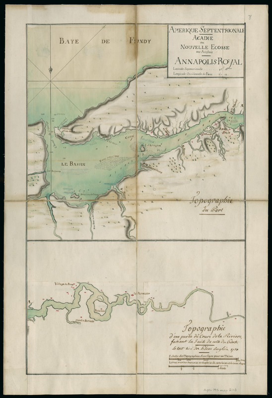
Amerique Septentrionale : Acadie ou Nouvelle Ecosse aux anglois : Annapolis Royal
This map is also available in American Revolutionary Geographies Online (ARGO), a collections portal especially built for material relating to the American Revolutionary War Era. Visit ARGO to learn more about this item and explore the historical geography of North America in the late eighteenth century.
Item Information
- Title:
- Amerique Septentrionale : Acadie ou Nouvelle Ecosse aux anglois : Annapolis Royal
- Title (alt.):
-
Annapolis Royal
- Description:
-
Details region centered on Annapolis Royal on the Annapolis River in Nova Scotia. Identifies rivers, anchorages, fortress, and individual buildings along the river valley.
- Date:
-
1750
- Format:
-
Maps/Atlases
Manuscripts
- Location:
- Newberry Library
- Collection (local):
-
Newberry Library Collection
- Subjects:
-
Manuscript maps--Early works to 1800
Annapolis Royal (N.S.)--Maps--Early works to 1800
- Places:
-
CanadaNova Scotia (province)Annapolis Royal
- Extent:
- 1 ms. map : hand col. ; on sheet 505 x 340 mm.
- Terms of Use:
-
No known copyright restrictions.
Contact host institution for more information.
- Scale:
-
Scale [ca. 1:99,000]
- Language:
-
French
- Catalog Record:
-
https://i-share-nby.primo.exlibrisgroup.com/permalink/01CARLI_NBY/i5mcb2/alma991477698805867
- Notes:
-
Probably compiled by French military engineers, but based on English sources: "Le tout tiré des plans anglois. 1750."
Drawn at consistent scale in two sections, the western above the eastern section.
Relief shown with soundings and shading.
Pen-and-ink and watercolor (green, yellow, red). Drawn on several pieces of paper pasted together as one sheet, sectioned into four panels and mounted on cloth.
- Call #:
-
Ayer MS map 210
![Combat naval à la hauteur de la Baye de Chézapeake [sic] le 5 7bre. 1781](https://bpldcassets.blob.core.windows.net/derivatives/images/commonwealth:z603vn12t/image_thumbnail_300.jpg)