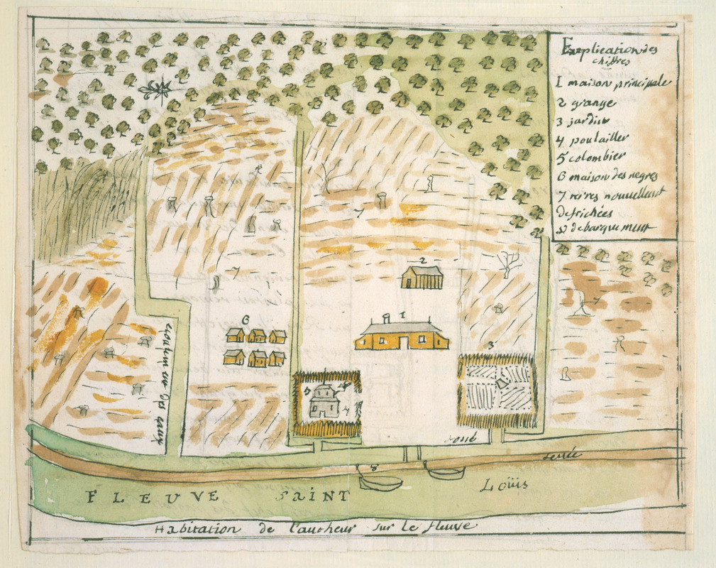
Habitation de l'autheur sur le fleuve
This map is also available in American Revolutionary Geographies Online (ARGO), a collections portal especially built for material relating to the American Revolutionary War Era. Visit ARGO to learn more about this item and explore the historical geography of North America in the late eighteenth century.
Item Information
- Title:
- Habitation de l'autheur sur le fleuve
- Description:
-
Map of French army officer Dumont de Montigny's plantation on the east side of the Mississippi River as it appeared ca. 1730. Established roughly ten leagues (about 28 miles) down river from New Orleans, on site later forming part of Plaquemines Parish. Identifies main house, outbuildings, slave quarters, cultivated fields, and garden; keyed to 8 references. From Dumont's 1747 manuscript memoir of his experiences in Louisiana between 1715-1737.
- Creator:
- Dumont de Montigny
- Date:
-
[1747]
- Format:
-
Maps/Atlases
Manuscripts
- Location:
- Newberry Library
- Collection (local):
-
Newberry Library Collection
- Subjects:
-
Plantations--Louisiana--Plaquemines Parish--Maps--Early works to 1800
Manuscript maps--Early works to 1800
Plaquemines Parish (La.)--Maps--Early works to 1800
Landowners--Louisiana--Plaquemines Parish--Maps--Early works to 1800
Dumont de Montigny
- Places:
-
LouisianaPlaquemines (county)
- Extent:
- 1 ms. map : hand col. ; 168 x 214 mm.
- Terms of Use:
-
No known copyright restrictions.
Contact host institution for more information.
- Scale:
-
Scale not given
- Language:
-
French
- Catalog Record:
-
https://i-share-nby.primo.exlibrisgroup.com/permalink/01CARLI_NBY/i5mcb2/alma991477258805867
- Notes:
-
Oriented with north at left.
Note on verso: No. 8, page 213.
Pen-and-ink and watercolor (green, yellow, brown).
No. 8 of 23 maps and drawings detached and bound together, from: Dumont de Montigny. Memoire de Lxx Dxx Officiere Ingenieur, contenant les evenemens qui se sont passés à la Louisiane depuis 1715 jusqu'a present [1747]
Ms. memoir adapted by Jean Baptiste Le Mascrier and published as Dumont de Montigny, Mémoires historiques sur la Louisiane. Paris: C.J.B. Bauche, 1753.
- Notes (date):
-
This date is inferred.
- Call #:
-
Ayer MS 257 map 8 (NLO)

![Combat naval à la hauteur de la Baye de Chézapeake [sic] le 5 7bre. 1781](https://bpldcassets.blob.core.windows.net/derivatives/images/commonwealth:z603vn12t/image_thumbnail_300.jpg)

