[Continuation of Plan du detroit de Belle Isle et du Golphe St. Laurent]
![[Continuation of Plan du detroit de Belle Isle et du Golphe St. Laurent]](https://bpldcassets.blob.core.windows.net/derivatives/images/commonwealth:z603vm96n/image_access_800.jpg)
This map is also available in American Revolutionary Geographies Online (ARGO), a collections portal especially built for material relating to the American Revolutionary War Era. Visit ARGO to learn more about this item and explore the historical geography of North America in the late eighteenth century.
Item Information
- Title:
- [Continuation of Plan du detroit de Belle Isle et du Golphe St. Laurent]
- Description:
-
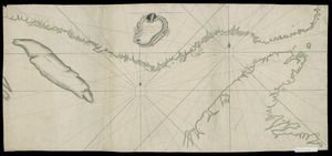
Shows the Saint Lawrence River Valley between the western tip of Anticosti Island and the city of Quebec. Untitled continuation, drawn at a reduced scale, of Chevalier de Dampierre's 1756 chart of the Strait of Belle Isle, northern Newfoundland, and the river (Ayer MS map 219).
- Creator:
- Dampierre, chevalier de, fl. 1756
- Date:
-
[1756?]
- Format:
-
Maps/Atlases
Manuscripts
- Location:
- Newberry Library
- Collection (local):
-
Edward E. Ayer Manuscript Map Collection
- Subjects:
-
Coasts--Saint Lawrence River Valley--Maps--Early works to 1800
Nautical charts--Saint Lawrence River--Early works to 1800
Manuscript maps--Early works to 1800
Saint Lawrence River Valley--Maps--Early works to 1800
- Places:
-
Saint Lawrence River
- Extent:
- 1 ms. map : hand col. ; 522 x 927 mm.
- Terms of Use:
-
No known copyright restrictions.
Contact host institution for more information.
- Scale:
-
Scale [ca. 1:568,000]
- Language:
-
French
- Catalog Record:
-
https://i-share-nby.primo.exlibrisgroup.com/permalink/01CARLI_NBY/i5mcb2/alma991466968805867
- Notes:
-
Pen-and-ink and wash (green, gray).
- Call #:
-
Ayer MS map 218 (NLO)