Toggle navigation
LMEC Home
Exhibitions
Georeferencing
Tools for Teachers
Collections
My Favorites
Sign Up / Log In
Search
Search the map portal
Map Collection
Map Collection
Map Sets
Search
Search
Search for
Search In
All Fields
Creator
Title
Subject
Place
Search All Digital Collections
Advanced Search
15 Results
My Search
Start Over
More Like
commonwealth:z603vm69r
Remove constraint More Like: commonwealth:z603vm69r
Filter your Search
Place
North and Central America
11
United States
5
Kentucky
2
Middle Atlantic
2
New Hampshire
2
Atlantic Ocean
1
Boston
1
Boston Harbor
1
more
Place
»
Topic
Middle Atlantic States--Maps--Early works to 1800
2
Boston (Mass.)--Maps--1775
1
Boston Harbor (Mass.)--Maps--Early works to 1800
1
Canada--History--To 1763 (New France)--Maps
1
Casco Bay (Me.)--Maps
1
Delaware--Maps--Early works to 1800
1
Great Lakes Region (North America)--Maps--Early works to 1800
1
Kennebec Patent--Maps
1
more
Topic
»
Date
Date range begin
–
Date range end
Current results range from
1746
to
1796
View distribution
Creator
Baldwin, Richard, 1724-1770
1
Bowen, Emanuel, -1767
1
Conder, Thomas, 1746 or 7-1831
1
Dixon, Jeremiah
1
Doolittle, Amos, 1754-1832
1
Evans, Lewis, 1700?-1756
1
Gridley, Richard, approximately 1710-1796
1
Harris, Cyrus
1
more
Creator
»
Format
Maps/Atlases
15
Georeferenced
Yes
1
No
14
Collection
American Revolutionary War-Era Maps
15
Massachusetts Historical Society Map Collection
14
MacLean Collection Map Library
1
Available to use
Creative Commons license
14
Search Constraints
Sort by relevance
relevance
title
date (asc)
date (desc)
Number of results to display per page
20 per page
10
per page
20
per page
50
per page
100
per page
View results as:
grid view
map view
Search Results
1.
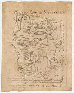
Plan of the town of Stratham
2.
Boston, with its environs
3.
Carte de l'Amérique septentrionale, 1754
4.
A map of Pensilvania, New-Jersey, New-York, and the three Delaware counties
5.
A map of that part of America where a degree of latitude was measured for the Royal Society
6.
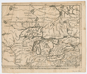
A Map of the five Great Lakes with part of Pensilvania, New York, Canada, and Hudsons Bay Territories &c
7.
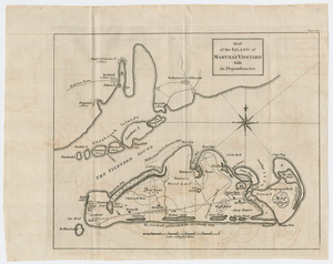
Map of the island of Martha's Vineyard with its dependencies
8.
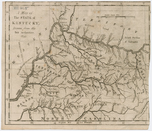
A map of the state of Kentucky
9.
A map of the state of Kentucky and the Tennessee government
10.
A map of the United States
11.
Map of the western parts of the colony of Virginia
12.
A new chart of the vast Atlantic Ocean
13.
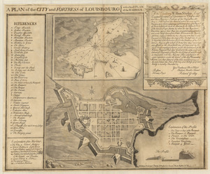
Plan of the city and fortress of Louisbourg
14.
The state of Massachusetts from the best information
15.
This plan of Kennebeck & Sagadahock Rivers & country adjacent