Toggle navigation
LMEC Home
Exhibitions
Georeferencing
Tools for Teachers
Collections
My Favorites
Sign Up / Log In
Search
Search the map portal
Map Collection
Map Collection
Map Sets
Search
Search
Search for
Search In
All Fields
Creator
Title
Subject
Place
Search All Digital Collections
Advanced Search
639 Results
My Search
Start Over
More Like
commonwealth:z603vh006
Remove constraint More Like: commonwealth:z603vh006
Filter your Search
Place
North and Central America
597
United States
443
Canada
151
Quebec
73
New York
60
North America
32
Saint Lawrence River
27
West Indies
23
more
Place
»
Topic
United States--Maps
330
United States--History--French and Indian War, 1754-1763--Maps
162
Canada--Maps
55
Elections--United States--Maps
36
Railroads--United States--Maps
34
North America--Maps
30
Saint Lawrence River--Maps
27
West Indies--Maps
24
more
Topic
»
Date
Date range begin
–
Date range end
Current results range from
1750
to
2023
View distribution
Creator
Paullin, Charles Oscar, 1868 or 1869-1944
70
Wright, John Kirtland, 1891-1969
70
Rocque, Mary Ann
24
Jefferys, Thomas, -1771
18
Geological Survey (U.S.)
15
Orme, Robert, -1781
14
Reid, John, 1764?-1828
11
Bellin, Jacques Nicolas, 1703-1772
10
more
Creator
»
Format
Maps/Atlases
636
Manuscripts
13
Prints
3
Books
1
Objects/Artifacts
1
Posters
1
Georeferenced
Yes
77
No
562
Collection
American Revolutionary War-Era Maps
325
Norman B. Leventhal Map & Education Center Collection
317
William L. Clements Library Collection
167
American Antiquarian Society Collection
138
MacLean Collection Map Library
11
Richard H. Brown Revolutionary War Map Collection at Mount Vernon
4
Boston and New England Maps
3
David Judkins Weaver Papers
2
more
Collection
»
Available to use
No known restrictions
243
Creative Commons license
10
Search Constraints
Sort by relevance
relevance
title
date (asc)
date (desc)
Number of results to display per page
20 per page
10
per page
20
per page
50
per page
100
per page
View results as:
grid view
map view
Search Results
241.
Appletons' railway map of the United States and Canada
242.
Appletons' railway map of the United States and the Canadas : representing railways in actual operation, and those in the...
243.
Armour food source map
244.
Base-map of the United States
245.
Being a map of the United States in the year 1831 when the Country Gentleman first made its appearance as the Genesee Farmer
246.
Broadway of America an all year ... all weather comfortable route from coast to coast
247.
Cantonment of the forces in N. America 1766
248.
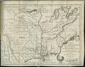
Carte de la Louisiane colonie francaise avec le cours du fleuve St. Louis, les rivieres adjacentes, les nations des naturels,...
249.
Carte des Etats-Unis
250.
Carte des Etats-Unis de l'Amérique-Nord : pour servir aux observations géologiqueir
251.
Carte générale des États-Unis de l'Amérique avec les plans des principales villes
252.
Carte generale des treize Etats-Unis & independants de l'Amerique Septentrional
253.
Case's map of the United States, the British provinces, Mexico, and part of the West Indies : compiled from the latest...
254.
Catholic America : a pictorial map portraying the contribution of Catholics in the development of the United States of America...
255.
Civil airways of the United States as designated in Civil Air Regulations - chapter 60
256.
Clemens' silent teacher, dissected map of the United States and of each state in counties
257.
Colton's general map of the United States : showing the railroad routes across the continent
258.
Colton's map of the United States of America, the British provinces, Mexico and the West Indies : showing the country from the...
259.
Colton's new railroad map of the United States & Canada
260.
Colton's plans of U.S. harbors : showing the position & vicinities of the most important fortifications on the sea-board and in...
‹ Prev
Next ›
1
2
…
9
10
11
12
13
14
15
16
17
…
31
32