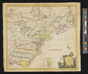
Cantonment of the forces in N. America 1766

This map is also available in American Revolutionary Geographies Online (ARGO), a collections portal especially built for material relating to the American Revolutionary War Era. Visit ARGO to learn more about this item and explore the historical geography of North America in the late eighteenth century.
Item Information
- Title:
- Cantonment of the forces in N. America 1766
- Date:
-
1766
- Format:
-
Maps/Atlases
- Genre:
-
Manuscript maps
- Location:
- William L. Clements Library
- Collection (local):
-
William L. Clements Library Collection
- Subjects:
-
United States--Maps
Canada, Eastern--Maps
Great Britain. Army
- Places:
-
United States
Canada
- Extent:
- 1 ms. map : col. ; 51.4 x 62 cm
- Terms of Use:
-
The University of Michigan Library provides access to these materials for educational and research purposes. These materials may be under copyright. If you decide to use any of these materials, you are responsible for making your own legal assessment and securing any necessary permission. If you have questions about the collection, please contact the William L. Clements Library.
Contact host institution for more information.
- Scale:
-
Scale ca. 1:6,500,000.
- Language:
-
English
- Catalog Record:
-
Catalog record
- Notes:
-
Finished, colored map of eastern North America showing the distribution of British forces with each unit identified by regimental number and by symbol down to company size.
Tables at right provide additional information about small detachments.
Map accompanied a chart entitled: General distribution of the troops in North America dated New York 22d Feby 1767 and issued by General Thomas Gage.
Sectioned and affixed to linen.
- Identifier:
-
530
- Barcode:
-
B1940953