Toggle navigation
LMEC Home
Exhibitions
Georeferencing
Tools for Teachers
Collections
My Favorites
Sign Up / Log In
Search
Search the map portal
Map Collection
Map Collection
Map Sets
Search
Search
Search for
Search In
All Fields
Creator
Title
Subject
Place
Search All Digital Collections
Advanced Search
111 Results
My Search
Start Over
More Like
commonwealth:xw42qw91v
Remove constraint More Like: commonwealth:xw42qw91v
Filter your Search
Place
North and Central America
111
United States
111
Middlesex (county)
40
Essex (county)
24
Bristol (county)
17
Lawrence
13
Hampden (county)
12
Lowell
12
more
Place
»
Topic
Lawrence (Mass.)--Maps
14
Lowell (Mass.)--Maps
12
Holyoke (Mass.)--Maps
9
Real property--Massachusetts--Lawrence--Maps
9
Haverhill (Mass.)--Maps
8
Real property--Massachusetts--Lowell--Maps
8
Landowners--Massachusetts--Lowell--Maps
7
Medford (Mass.)--Maps
7
more
Topic
»
Date
Date range begin
–
Date range end
Current results range from
1770
to
2022
View distribution
Creator
Geo. H. Walker & Co.
16
Walling, Henry Francis, 1825-1888
7
L.J. Richards & Co.
6
D.L. Miller & Co.
4
Home Owners' Loan Corporation
4
Hopkins, Griffith Morgan, Jr.
4
Richards Map Company
4
Beers, F. W. (Frederick W.)
3
more
Creator
»
Format
Maps/Atlases
111
Books
7
Manuscripts
2
Georeferenced
Yes
14
No
97
Collection
Norman B. Leventhal Map Center Collection
76
Boston and New England Maps
69
Urban Maps
65
Massachusetts Real Estate Atlases
25
American Revolutionary War-Era Maps
6
William L. Clements Library Collection
6
Mapping Inequality Collection
4
Applied Geographics, Inc. Records
1
Available to use
No known restrictions
75
Creative Commons license
5
Search Constraints
Sort by relevance
relevance
title
date (asc)
date (desc)
Number of results to display per page
50 per page
10
per page
20
per page
50
per page
100
per page
View results as:
grid view
map view
Search Results
1.
Atlas of Middlesex County. Vol. 1. Cambridge, Somerville, Arlington, Belmont, Watertown, Everett, Malden, Medford, Newton,...
2.
Atlas of Essex County, Massachusetts
3.
Atlas of Middlesex County. Vol. 2. Cities of Melrose & Woburn, towns of Bedford, Burlington, Concord, North Reading, Reading,...
4.
Combined map of Holyoke and Chicopee
5.
The Price & Lee Co's new map of the city of Holyoke and part of the city of Chicopee, Mass
6.
Map of Bristol County Massachusetts : based on the trigonometrical survey of the state
7.
Atlas of the towns of North Adams, Adams, Williamstown and Cheshire, Berkshire County, Massachusetts
8.
Atlas of the city of Fitchburg, Worcester County, Massachusetts : from official records and surveys
9.
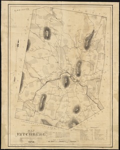
A map of Fitchburg, Mass
10.
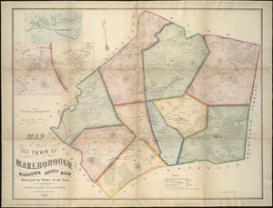
Map of the town of Marlborough
11.
Marlborough, Middlesex County, Massachusetts
12.
Atlas of Northampton City, Massachusetts
13.
Atlas of the city of Northampton and the town of Easthampton, Hampshire County, Massachusetts
14.
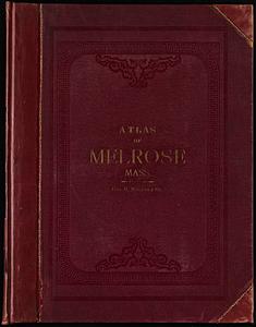
Atlas of the town of Melrose, Middlesex County, Massachusetts
15.
City of Melrose assessors plans
16.
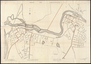
City of Chicopee
17.
Plan of Springfield
18.
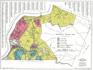
Residential security map of Chicopee, Mass.
19.
Atlas of the towns of Watertown, Belmont, Arlington and Lexington, Middlesex County, Mass. : from official plans and actual...
20.
Town of Belmont Assessors plans
21.
Town of Belmont Massachusetts
22.
Atlas of the city of Pittsfield, Berkshire County, Massachusetts
23.
Pittsfield
24.
Shaker Village
25.
Topographical map of Pittsfield, Berkshire Co., Mass : from actual surveys and records
26.
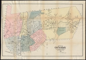
Atlas of Malden City, Massachusetts
27.
Atlas of the city of Malden, Massachusetts
28.
Atlas of the town of Woburn, Massachusetts
29.
Insurance maps of Malden, Middlesex Co., Massachusetts
30.
Map of the city of Malden
31.
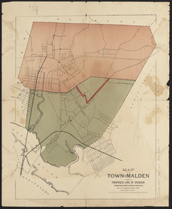
Map of the town of Malden showing the proposed line of division compiled from various surveys
32.
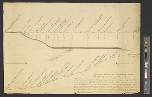
A plan & section of a survey taken April 20, 1801 on a new prepared course for the Middlesex Canal, from the south end of...
33.
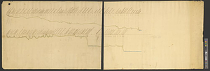
A plan and section of the two routs in Woburn, say 1795 : Middlesex Canal
34.
Woburn, Mass., 1883
35.
Atlas of the city of Brockton, Mass.
36.
City of Brockton
37.
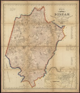
Map of the town of Dedham, Norfolk County, Massachusetts
38.
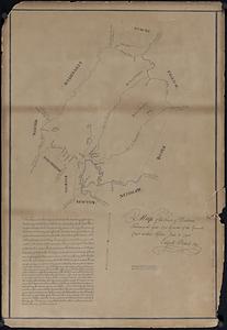
Map of the town of Dedham taken in the year 1795 by order of the General Court at their session June 18 1794
39.
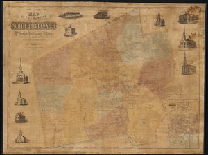
Map of the town of North Bridgewater : Plymouth County Mass., surveyed by order of the town
40.
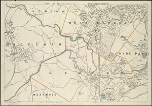
Part of the metropolitan district
41.
Residential security map of Brockton, Mass.
42.
Town of Dedham Massachusetts
43.
The town of Dedham, Massachusetts : a pictorial map
44.
Atlas, city of Everett, Middlesex County, Massachusetts
45.
Atlas of the city of Everett, Mass.
46.
Atlas of the city of Medford, Middlesex County, Mass. ; Atlas of the town of Hyde Park, Norfolk County, Mass. ; Atlas of the...
47.
Map of Chelsea, Everett, Revere, & Winthrop
48.
Map of Everett and vicinity
49.
Map of the town of Medford, Middlesex County, Mass : surveyed by order of the town
50.
Plan of lots in Medford, formerly owned by Joseph B. Felt, and known as the John Quincy Adams Estate
‹ Prev
Next ›
1
2
3