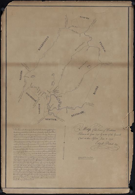
Map of the town of Dedham taken in the year 1795 by order of the General Court at their session June 18 1794
Item Information
- Title:
- Map of the town of Dedham taken in the year 1795 by order of the General Court at their session June 18 1794
- Cartographer:
- Pond, Eliphalet
- Name on Item:
-
Eliph. Pond sur.
- Date:
-
[ca. 1886]
- Format:
-
Maps/Atlases
- Genre:
-
Manuscript maps
- Location:
-
Boston Public Library
Norman B. Leventhal Map & Education Center - Collection (local):
-
Norman B. Leventhal Map & Education Center Collection
- Subjects:
-
Dedham (Mass.)--Maps
- Places:
-
MassachusettsNorfolk (county)Dedham
- Extent:
- 1 manuscript map : on paperboard ; 67 x 45 cm
- Terms of Use:
-
No known copyright restrictions.
No known restrictions on use.
- Scale:
-
Scale 1:39,600. 50 chains or 200 rods to an inch
- Language:
-
English
- Notes:
-
Manuscript copy of the 1795 manuscript town plan of Dedham by Eliphalet Pond, held by the Massachusetts State Archives.
Oriented with north to the bottom.
Includes text.
Cartographer often listed as Elijah Pond.
- Notes (acquisition):
-
Gift of Mary Anne Osborne, 2021.
- Identifier:
-
06_01_017923
- Call #:
-
G3764.D4 1795 .P66 1886
- Barcode:
-
39999085964037