Toggle navigation
LMEC Home
Exhibitions
Georeferencing
Tools for Teachers
Collections
My Favorites
Sign Up / Log In
Search
Search the map portal
Map Collection
Map Collection
Map Sets
Search
Search
Search for
Search In
All Fields
Creator
Title
Subject
Place
Search All Digital Collections
Advanced Search
8702 Results
My Search
Start Over
More Like
commonwealth:x059cd58g
Remove constraint More Like: commonwealth:x059cd58g
Filter your Search
Place
North and Central America
5,933
United States
4,846
Massachusetts
2,079
Europe
1,396
Suffolk (county)
1,046
Boston
1,019
Canada
450
Asia
438
more
Place
»
Topic
Boston (Mass.)--Maps
586
United States--Maps
282
Real property--Massachusetts--Boston--Maps
175
Massachusetts--Maps
162
Landowners--Massachusetts--Boston--Maps
133
North America--Maps--Early works to 1800
103
New England--Maps
102
Europe--Maps
79
more
Topic
»
Date
Date range begin
–
Date range end
Current results range from
1482
to
2023
View distribution
Creator
United States. Hydrographic Office
595
O.H. Bailey & Co
148
Des Barres, Joseph F. W. (Joseph Frederick Wallet), 1722-1824
123
United States. Post Office Dept
120
Ptolemy, 2nd cent
100
Walling, Henry Francis, 1825-1888
94
Geological Survey (U.S.)
86
Jefferys, Thomas, -1771
85
more
Creator
»
Format
Maps/Atlases
8,642
Manuscripts
215
Prints
56
Books
36
Objects/Artifacts
10
Drawings/Illustrations
8
Posters
5
Georeferenced
Yes
868
No
7,834
Collection
Norman B. Leventhal Map & Education Center Collection
8,694
Boston and New England Maps
2,232
Urban Maps
2,023
Maritime Charts and Atlases
1,083
American Revolutionary War-Era Maps
623
Boston Redevelopment Authority Collection
87
Richard H. Brown Revolutionary War Map Collection at Mount Vernon
3
MacLean Collection Map Library
2
more
Collection
»
Available to use
No known restrictions
8,552
Creative Commons license
53
Search Constraints
Sort by relevance
relevance
title
date (asc)
date (desc)
Number of results to display per page
20 per page
10
per page
20
per page
50
per page
100
per page
View results as:
grid view
map view
Search Results
1.
An accurate map of His Majesty's province of New-Hampshire in New England : taken from actual surveys of all the inhabited...
2.
Carte de la Nouvelle York, y-compris les terres cédées du N. Hamp-Shire, sous le nom d'etat de Vermont
3.
A map of the inhabited part of Canada from the French surveys : with the frontiers of New York and New England from the large...
4.
An accurate map of His Majesty's province of New-Hampshire in New England : taken from actual surveys of all the inhabited...
5.
A chorographical map of the northern department of North-America
6.
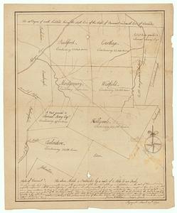
Map of northern Vermont townships
7.
A map of the country in which the army under Lt. General Burgoyne acted in the campaign of 1777 : shewing the marches of the...
8.
A map of the country in which the army under Lt. General Burgoyne acted in the campaign of 1777 : shewing the marches of the...
9.
A map of the inhabited part of Canada from the French surveys : with the frontiers of New York and New England from the large...
10.
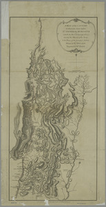
Plan of Part of Black River & Part of Otter Creek with the Distances by Computation
11.
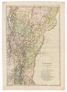
Vermont
12.
The 100th anniversary map of Abraham Lincoln's visit to Massachusetts, September 11-23, 1848
13.
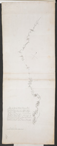
1630 shoreline
14.
1879. Progress map of the U.S. Geographical Surveys west of the 100th Meridian : prepared under the direction of 1st Lieut....
15.
1903 Map of Salem and surrounding places
16.
19th annual convention of the National Association of Real Estate Boards : at Tulsa, June 7 to June 11 in 1926
17.
2005 significant U.S. hurricane strikes
18.
The 2100 project : an atlas for the Green New Deal
19.
227 Harzgerode
20.
305 Glatz
‹ Prev
Next ›
1
2
3
4
5
…
435
436