Toggle navigation
LMEC Home
Exhibitions
Georeferencing
Tools for Teachers
Collections
My Favorites
Sign Up / Log In
Search
Search the map portal
Map Collection
Map Collection
Map Sets
Search
Search
Search for
Search In
All Fields
Creator
Title
Subject
Place
Search All Digital Collections
Advanced Search
8873 Results
My Search
Start Over
More Like
commonwealth:wd376685k
Remove constraint More Like: commonwealth:wd376685k
Filter your Search
Place
North and Central America
6,104
United States
5,020
Massachusetts
2,139
Europe
1,396
Suffolk (county)
1,219
Boston
1,192
Canada
449
Asia
438
more
Place
»
Topic
Boston (Mass.)--Maps
752
United States--Maps
282
Real property--Massachusetts--Boston--Maps
195
City planning--Massachusetts--Boston--Maps
168
Massachusetts--Maps
166
Landowners--Massachusetts--Boston--Maps
142
New England--Maps
104
North America--Maps--Early works to 1800
103
more
Topic
»
Date
Date range begin
–
Date range end
Current results range from
1482
to
2023
View distribution
Creator
United States. Hydrographic Office
595
Boston Redevelopment Authority
171
O.H. Bailey & Co
148
Des Barres, Joseph F. W. (Joseph Frederick Wallet), 1722-1824
124
United States. Post Office Dept
120
Ptolemy, 2nd cent
100
Walling, Henry Francis, 1825-1888
94
Geological Survey (U.S.)
87
more
Creator
»
Format
Maps/Atlases
8,813
Manuscripts
215
Prints
56
Books
36
Objects/Artifacts
10
Drawings/Illustrations
8
Posters
5
Georeferenced
Yes
885
No
7,988
Collection
Norman B. Leventhal Map & Education Center Collection
8,723
Boston and New England Maps
2,369
Urban Maps
2,153
Maritime Charts and Atlases
1,083
American Revolutionary War-Era Maps
638
Boston Redevelopment Authority Collection
203
Mapping Boston Collection
20
Massachusetts Real Estate Atlases
12
more
Collection
»
Available to use
No known restrictions
8,676
Creative Commons license
70
Search Constraints
Sort by relevance
relevance
title
date (asc)
date (desc)
Number of results to display per page
20 per page
10
per page
20
per page
50
per page
100
per page
View results as:
grid view
map view
Search Results
6341.
Plan and sections Isaacs Harbour gold district, Guysborough Co., Nova Scotia
6342.
Plan and sections Malaga gold district, Queens Co., Nova-Scotia
6343.
Plan and sections of Fort Fisher, carried by assault by the U.S. forces, Maj. Gen. A.H. Terry commanding, Jan. 15th, 1865
6344.
Plan and sections, Oldham gold district, Halifax Co., N.S
6345.
Plan and sections Renerew gold district, Hants Co. Nova Scotia
6346.
Plan and sections Upper Seal Harbour, Guysborough Co., N.S
6347.
Plan and sections Waverley gold district, Halifax Co., Nova Scotia
6348.
Plan and sections Wine Harbour gold district, Guysborough Co., Nova Scotia
6349.
[Plan d'Amboy : vues de la rade de Charles-Town et de Fort Sulivan, mai 1780]
6350.
Plan de Boston
6351.
Plan de Boston
6352.
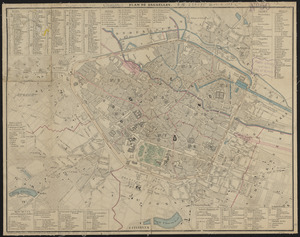
Plan de Bruxelles
6353.
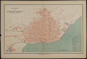
Plan de Buenos-Ayres (Confédération Argentine)
6354.
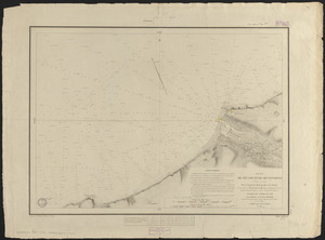
Plan de Fécamp et de ses environs
6355.
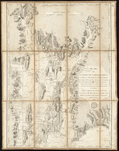
Plan de la baie de Narraganset dans la Nouvelle Angleterre : avec toutes les îles qu'elle renferme parmi lesquelles se...
6356.
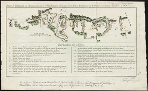
Plan de la bataille de Montmouth où le Gl. Washington commandait l'Armée Américaine et le Gl. Clinton l'Armée Anglaise, le...
6357.
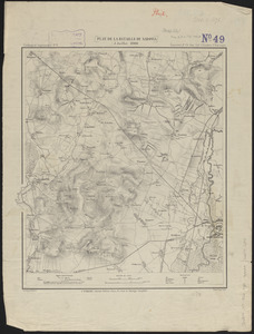
Plan de la bataille de Sadowa
6358.
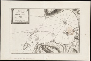
Plan de la Baye Saint Louis dans l'isle de St. Domingue
6359.
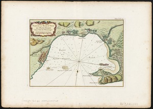
Plan de la Rade et Ville du Petit Goave dans i'Isle de St. Domingue
6360.
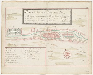
Plan de la Riviere de Seine dans Paris
‹ Prev
Next ›
1
2
…
314
315
316
317
318
319
320
321
322
…
443
444