Toggle navigation
LMEC Home
Exhibitions
Georeferencing
Tools for Teachers
Collections
My Favorites
Sign Up / Log In
Search
Search the map portal
Map Collection
Map Collection
Map Sets
Search
Search
Search for
Search In
All Fields
Creator
Title
Subject
Place
Search All Digital Collections
Advanced Search
8931 Results
My Search
Start Over
More Like
commonwealth:wd376610h
Remove constraint More Like: commonwealth:wd376610h
Filter your Search
Place
North and Central America
6,162
United States
5,064
Massachusetts
2,194
Europe
1,396
Suffolk (county)
1,207
Boston
1,180
Canada
450
Asia
438
more
Place
»
Topic
Boston (Mass.)--Maps
752
United States--Maps
282
Massachusetts--Maps
235
Real property--Massachusetts--Boston--Maps
195
City planning--Massachusetts--Boston--Maps
157
Landowners--Massachusetts--Boston--Maps
142
New England--Maps
106
North America--Maps--Early works to 1800
103
more
Topic
»
Date
Date range begin
–
Date range end
Current results range from
1482
to
2023
View distribution
Creator
United States. Hydrographic Office
595
Boston Redevelopment Authority
162
O.H. Bailey & Co
148
Des Barres, Joseph F. W. (Joseph Frederick Wallet), 1722-1824
124
United States. Post Office Dept
120
Ptolemy, 2nd cent
100
Walling, Henry Francis, 1825-1888
95
Geological Survey (U.S.)
92
more
Creator
»
Format
Maps/Atlases
8,870
Manuscripts
217
Prints
56
Books
36
Objects/Artifacts
10
Drawings/Illustrations
8
Posters
5
Ephemera
1
Georeferenced
Yes
893
No
8,038
Collection
Norman B. Leventhal Map & Education Center Collection
8,764
Boston and New England Maps
2,403
Urban Maps
2,143
Maritime Charts and Atlases
1,083
American Revolutionary War-Era Maps
657
Boston Redevelopment Authority Collection
194
Mapping Boston Collection
22
Applied Geographics, Inc. Records
21
more
Collection
»
Available to use
No known restrictions
8,706
Creative Commons license
73
Search Constraints
Sort by relevance
relevance
title
date (asc)
date (desc)
Number of results to display per page
20 per page
10
per page
20
per page
50
per page
100
per page
View results as:
grid view
map view
Search Results
5481.
A new and accurate map of the colony of Massachusets Bay, in North America, from a late survey
5482.
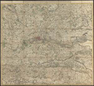
A new and accurate map of the country twenty-five miles round London : on which are delineated from an actual survey, His...
5483.
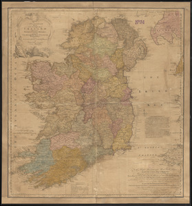
A new and accurate map of the kingdom of Ireland divided into provinces, counties & baronies : with all the cities, boroughs,...
5484.
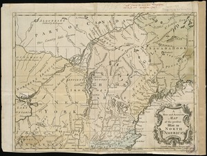
A new and accurate map of the present seat of war in North America
5485.
A New and accurate map of the present seat of war in North America, comprehending New Jersey, Philadelphia, Pensylvania,...
5486.
A new and accurate map of the present war in North America
5487.
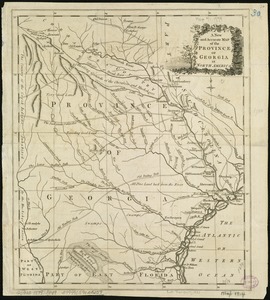
A New and accurate map of the province of Georgia in North America
5488.
A new and accurate map of the province of New York and part of the Jerseys, New England and Canada, shewing the scenes of our...
5489.
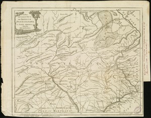
A new and accurate map of the province of Pennsylvania in North America, from the best authorities
5490.
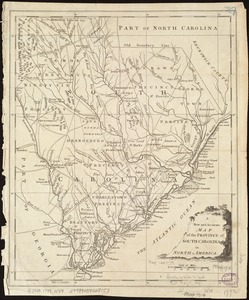
A New and accurate map of the province of South Carolina in North America
5491.
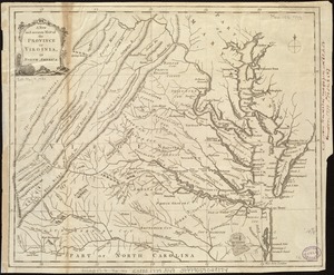
A new and accurate map of the province of Virginia in North America
5492.
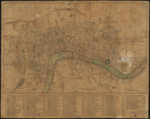
A new and accurate plan of London, Westminster and the Borough of Southwark, with all the additional streets, squares, &c :...
5493.
A new and accurate plan of the town of Boston in New England : A new plan of Boston Harbor from an actual survey
5494.
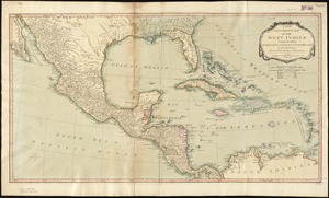
A new and complete map of the West Indies : comprehending all the coasts and islands known by that name
5495.
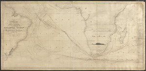
A new and correct chart of the Atlantic Ocean
5496.
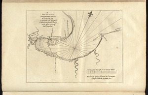
A new and correct draught of the bay of Matanzas : on ye north side of ye island of Cuba ; done from a survey in the year 1729...
5497.
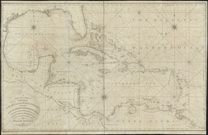
A new and correct general chart of the West Indies including the Gulf of Mexico & Bay of Honduras &c : collected from the...
5498.
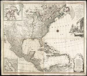
A new and correct map of North America, with the West India Islands : divided according to the last Treaty of Peace, concluded...
5499.
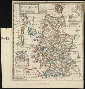
A new and correct map of Scotland and the Isles : containing all ye cities, market towns, boroughs &c., the principal roads,...
5500.
A New and correct map of the British colonies in North America comprehending eastern Canada with the province of Quebec, New...
‹ Prev
Next ›
1
2
…
271
272
273
274
275
276
277
278
279
…
446
447