Toggle navigation
LMEC Home
Exhibitions
Georeferencing
Tools for Teachers
Collections
My Favorites
Sign Up / Log In
Search
Search the map portal
Map Collection
Map Collection
Map Sets
Search
Search
Search for
Search In
All Fields
Creator
Title
Subject
Place
Search All Digital Collections
Advanced Search
8608 Results
My Search
Start Over
More Like
commonwealth:wd376556x
Remove constraint More Like: commonwealth:wd376556x
Filter your Search
Place
North and Central America
5,903
United States
4,811
Massachusetts
2,108
Europe
1,359
Suffolk (county)
1,035
Boston
1,008
Canada
448
Asia
422
more
Place
»
Topic
Boston (Mass.)--Maps
580
United States--Maps
273
Massachusetts--Maps
218
Real property--Massachusetts--Boston--Maps
174
Landowners--Massachusetts--Boston--Maps
132
North America--Maps--Early works to 1800
103
New England--Maps
100
Europe--Maps
78
more
Topic
»
Date
Date range begin
–
Date range end
Current results range from
1482
to
2023
View distribution
Creator
United States. Hydrographic Office
594
O.H. Bailey & Co
148
Des Barres, Joseph F. W. (Joseph Frederick Wallet), 1722-1824
123
United States. Post Office Dept
120
Ptolemy, 2nd cent
100
Walling, Henry Francis, 1825-1888
95
Geological Survey (U.S.)
92
Jefferys, Thomas, -1771
85
more
Creator
»
Format
Maps/Atlases
8,548
Manuscripts
217
Prints
56
Books
36
Objects/Artifacts
10
Drawings/Illustrations
8
Posters
4
Ephemera
1
Georeferenced
Yes
878
No
7,730
Collection
Norman B. Leventhal Map & Education Center Collection
8,578
Boston and New England Maps
2,236
Urban Maps
1,937
Maritime Charts and Atlases
1,081
American Revolutionary War-Era Maps
634
Boston Redevelopment Authority Collection
90
David Judkins Weaver Papers
17
Sidney R. Knafel Map Collection at Phillips Academy
8
more
Collection
»
Available to use
No known restrictions
8,437
Creative Commons license
50
Search Constraints
Sort by relevance
relevance
title
date (asc)
date (desc)
Number of results to display per page
20 per page
10
per page
20
per page
50
per page
100
per page
View results as:
grid view
map view
Search Results
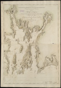
1621.
[Chart of the gulf and river of St. Lawrence]
1622.
A chart of the harbour of Boston
1623.
A chart of the harbour of Boston
1624.
A chart of the harbour of Boston
1625.
A chart of the Harbour of Boston, with the soundings, sailing-marks, and other directions
1626.
A chart of the harbour of Halifax in Nova Scotia : with Jebucto Bay and Cape Sambro also the islands, ledges of rocks, shoals &...
1627.
A chart of the harbour of Rhode Island and Narraganset Bay
1628.
A chart of the harbour of Rhode Island and Narraganset Bay
1629.
Chart of the harbours of Salem, Marblehead, Beverly and Manchester : from a survey taken in the years 1804, 5 & 6
1630.
Chart of the harbours of Salem, Marblehead, Beverly, and Manchester : from a survey taken in the years 1804, 5 & 6
1631.
A chart of the history of printing in Europe
1632.
A chart of the iland of Hispaniola : with the Windward passage from Iamaica betwene ye east end of Cuba & the west end of...
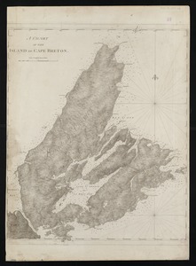
1633.
A chart of the island of Cape Breton
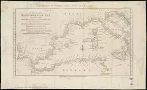
1634.
A chart of the Mediterranean Sea, with part of the Atlantic Ocean and Adriatic Sea, with the islands of Minorca, Majorca,...
1635.
Chart of the Mississippi River from the Ohio River to Gulf of Mexico : constructed and engraved to illustrate "The War with the...
1636.
A chart of the N.E. coast of Cape Breton Island, from St. Ann Bay to Cape Morien
1637.
Chart of the north east coast of New Caledonia and part of the New Hebrides
1638.
A Chart of the north part of America, describing the sea coast of Groenland, Dawies Streights, Baffins Bay, Hudsons Streights,...
1639.
A chart of the North-American coast, for the navigation between Halifax and Philadelphia
1640.
Chart of the Northern Passage between Asia & America
‹ Prev
Next ›
1
2
…
78
79
80
81
82
83
84
85
86
…
430
431
![[Chart of the gulf and river of St. Lawrence]](https://bpldcassets.blob.core.windows.net/derivatives/images/commonwealth:7h149v39v/image_thumbnail_300.jpg)