Toggle navigation
LMEC Home
Exhibitions
Georeferencing
Tools for Teachers
Collections
My Favorites
Sign Up / Log In
Search
Search the map portal
Map Collection
Map Collection
Map Sets
Search
Search
Search for
Search In
All Fields
Creator
Title
Subject
Place
Search All Digital Collections
Advanced Search
8972 Results
My Search
Start Over
More Like
commonwealth:wd376542k
Remove constraint More Like: commonwealth:wd376542k
Filter your Search
Place
North and Central America
6,207
United States
5,090
Massachusetts
2,084
Europe
1,392
Suffolk (county)
1,062
Boston
1,030
Canada
463
Asia
437
more
Place
»
Topic
Boston (Mass.)--Maps
591
United States--History--Revolution, 1775-1783--Maps
330
United States--Maps
280
Real property--Massachusetts--Boston--Maps
175
Massachusetts--Maps
162
Landowners--Massachusetts--Boston--Maps
133
North America--Maps--Early works to 1800
103
New England--Maps
102
more
Topic
»
Date
Date range begin
–
Date range end
Current results range from
1482
to
2023
View distribution
Creator
United States. Hydrographic Office
595
O.H. Bailey & Co
148
Des Barres, Joseph F. W. (Joseph Frederick Wallet), 1722-1824
124
United States. Post Office Dept
120
Ptolemy, 2nd cent
100
Walling, Henry Francis, 1825-1888
94
Geological Survey (U.S.)
86
Jefferys, Thomas, -1771
86
more
Creator
»
Format
Maps/Atlases
8,907
Manuscripts
219
Prints
56
Books
36
Drawings/Illustrations
13
Objects/Artifacts
10
Posters
5
Georeferenced
Yes
871
No
8,101
Collection
Norman B. Leventhal Map & Education Center Collection
8,648
Boston and New England Maps
2,221
Urban Maps
1,992
Maritime Charts and Atlases
1,083
American Revolutionary War-Era Maps
940
William L. Clements Library Collection
305
Boston Redevelopment Authority Collection
87
American Antiquarian Society Collection
8
more
Collection
»
Available to use
No known restrictions
8,507
Creative Commons license
52
Search Constraints
Sort by relevance
relevance
title
date (asc)
date (desc)
Number of results to display per page
20 per page
10
per page
20
per page
50
per page
100
per page
View results as:
grid view
map view
Search Results
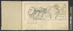
21.
Battle of Monmouth, 28th June 1778
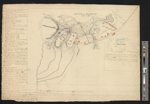
22.
Battle of Monmouth, 28th June 1778
23.
Bedford
24.
Bedford &c.
25.
Blackwell's Island
26.
Boston
27.
Boston Harbor
28.
Boston Harbor, 1778
29.
Boston its environs and harbour, : with the rebels works raised against that town in 1775, from the observations of Lieut. Page...
30.
Bridge from Staten Island to the Jersies, by Cn. Laird's description
31.
British capture of Savannah
32.
British troop dispositions in and near New York City
33.
British troop dispositions in and near New York City, July and August 1781
34.
British troop dispositions in and near New York City, Sept. 2d 1781
35.
The British works at Yorktown and Gloucester
36.
Burlington, New Jersey, and Bristol, Pennsylvania
37.
Cambridge to Prospect Hill
38.
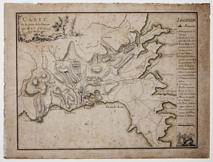
Carte de la prise de la Grenade par Mr. Cmte. d'Estaing, le 5 juillet 1779
39.
Carte de l'affaire de Montmouth, ou le Général Washington commandon l'armée Americaine, et le Général Clinton l'armée...
40.
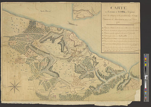
Carte des environs de York en Virginie avec les attaques et la position des armées Françoise et Américaine, devant cette place...
‹ Prev
Next ›
1
2
3
4
5
6
…
448
449