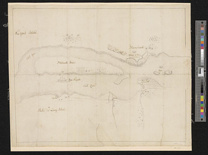
Blackwell's Island
This map is also available in American Revolutionary Geographies Online (ARGO), a collections portal especially built for material relating to the American Revolutionary War Era. Visit ARGO to learn more about this item and explore the historical geography of North America in the late eighteenth century.
Item Information
- Title:
- Blackwell's Island
- Contributor:
- Paule
- Date:
-
[ca. 1776]
- Format:
-
Maps/Atlases
- Genre:
-
Manuscript maps
- Location:
- William L. Clements Library
- Collection (local):
-
William L. Clements Library Collection
- Subjects:
-
Roosevelt Island (New York, N.Y.)--Maps
United States--History--Revolution, 1775-1783--Maps
- Places:
-
New YorkNew York (county)Roosevelt Island (island)
- Extent:
- 1 ms. map ; 31.4 x 42 cm
- Terms of Use:
-
The University of Michigan Library provides access to these materials for educational and research purposes. These materials may be under copyright. If you decide to use any of these materials, you are responsible for making your own legal assessment and securing any necessary permission. If you have questions about the collection, please contact the William L. Clements Library.
Contact host institution for more information.
- Scale:
-
Scale [ca. 1:15,600].
- Language:
-
French
English
- Catalog Record:
-
Catalog record
- Notes:
-
Pencil topographical sketch showing modern Roosevelt Island and surrounding area.
Details of map represent events of September 1776 during the New York campaign.
New-York Historical Society has a similar map signed "Paule" that appears to be by the same hand.
Map shows fortifications and camp of American troops evacuated on September 5, 1776.
Clinton Maps 147.
- Identifier:
-
1811
- Barcode:
-
B1936385


