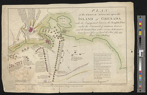
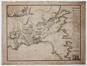
Carte de la prise de la Grenade par Mr. Cmte. d'Estaing, le 5 juillet 1779
This map is also available in American Revolutionary Geographies Online (ARGO), a collections portal especially built for material relating to the American Revolutionary War Era. Visit ARGO to learn more about this item and explore the historical geography of North America in the late eighteenth century.
Item Information
- Title:
- Carte de la prise de la Grenade par Mr. Cmte. d'Estaing, le 5 juillet 1779
- Creator:
- Warin, cartographer
- Name on Item:
-
Warin, f.
- Date:
-
[1779?]
- Format:
-
Maps/Atlases
- Genre:
-
Manuscript maps
- Location:
- William L. Clements Library
- Collection (local):
-
William L. Clements Library Collection
- Subjects:
-
Grenada, Battle of, 1779--Maps
United States--History--Revolution, 1775-1783--Maps
- Places:
-
Grenada
- Extent:
- 1 ms. map : col. ; 34.5 x 45.8 cm.
- Terms of Use:
-
The University of Michigan Library provides access to these materials for educational and research purposes. These materials may be under copyright. If you decide to use any of these materials, you are responsible for making your own legal assessment and securing any necessary permission. If you have questions about the collection, please contact the William L. Clements Library.
Contact host institution for more information.
- Scale:
-
Scale indeterminable.
- Language:
-
French
- Catalog Record:
-
Catalog record
- Notes:
-
Finished, colored pen and ink map showing the movements of the French army during the capture of Grenada.
Relief shown pictorially and by hachures.
North oriented to left.
Includes table of reference to troop positions and movements.
Cartouche includes illustration of rocky landscape, two trees, and a house.
In lower right: illustration of helmets, sword hilt and shield.
- Identifier:
-
651
- Barcode:
-
B6114803