Toggle navigation
LMEC Home
Exhibitions
Georeferencing
Tools for Teachers
Collections
My Favorites
Sign Up / Log In
Search
Search the map portal
Map Collection
Map Collection
Map Sets
Search
Search
Search for
Search In
All Fields
Creator
Title
Subject
Place
Search All Digital Collections
Advanced Search
8972 Results
My Search
Start Over
More Like
commonwealth:wd376542k
Remove constraint More Like: commonwealth:wd376542k
Filter your Search
Place
North and Central America
6,207
United States
5,090
Massachusetts
2,084
Europe
1,392
Suffolk (county)
1,062
Boston
1,030
Canada
463
Asia
437
more
Place
»
Topic
Boston (Mass.)--Maps
591
United States--History--Revolution, 1775-1783--Maps
330
United States--Maps
280
Real property--Massachusetts--Boston--Maps
175
Massachusetts--Maps
162
Landowners--Massachusetts--Boston--Maps
133
North America--Maps--Early works to 1800
103
New England--Maps
102
more
Topic
»
Date
Date range begin
–
Date range end
Current results range from
1482
to
2023
View distribution
Creator
United States. Hydrographic Office
595
O.H. Bailey & Co
148
Des Barres, Joseph F. W. (Joseph Frederick Wallet), 1722-1824
124
United States. Post Office Dept
120
Ptolemy, 2nd cent
100
Walling, Henry Francis, 1825-1888
94
Geological Survey (U.S.)
86
Jefferys, Thomas, -1771
86
more
Creator
»
Format
Maps/Atlases
8,907
Manuscripts
219
Prints
56
Books
36
Drawings/Illustrations
13
Objects/Artifacts
10
Posters
5
Georeferenced
Yes
871
No
8,101
Collection
Norman B. Leventhal Map & Education Center Collection
8,648
Boston and New England Maps
2,221
Urban Maps
1,992
Maritime Charts and Atlases
1,083
American Revolutionary War-Era Maps
940
William L. Clements Library Collection
305
Boston Redevelopment Authority Collection
87
American Antiquarian Society Collection
8
more
Collection
»
Available to use
No known restrictions
8,507
Creative Commons license
52
Search Constraints
Sort by relevance
relevance
title
date (asc)
date (desc)
Number of results to display per page
20 per page
10
per page
20
per page
50
per page
100
per page
View results as:
grid view
map view
Search Results
1.
Gen. Washington's Revolutionary campaign war map : after a survey ordered by him showing the position of his army in defence of...
2.
Sketch of Bunker Hill Battle
3.
Boston over Time
4.
Sketch of the Battle of Bunker Hill
5.
Atlas to Marshall's life of Washington
6.
Centennial map of Concord, 1775-1875
7.
Map of the vicinity of Yorktown, Virginia, 1881
8.
Plan of the town of Boston with the attack on Bunkers-Hill in the peninsula of Charlestown the 17th of June 1775
9.
Boston with its environs
10.
A Plan of Boston, and its environs. : Shewing the true situation of His Majesty's army. And also those of the rebels
11.
An accurate map of the United States of America : according to the Treaty of Peace of 1783
12.
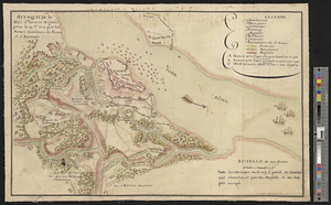
Affaire de Monmouth ce 28me Juin 1778
13.
American camp at Valley Forge
14.
Amérique Septentrionale, Yorck : reconnoissance des ouvrages de cette ville ave le tracé des attaques dirigées contre eux
15.
The attack and defeat of the American fleet under Benedict Arnold, by the kings fleet commanded by Captn. Thos. Pringle, upon...
16.
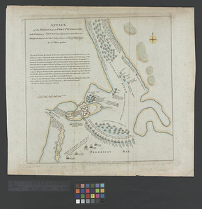
Attack of the rebels upon Fort Penobscot in the province of New England in which their fleet was totally destroyed and their...
17.
Attaque de la ville d'York en Virginie prise le 19 8bre 1781 par les armées combinées de France et d'Amérique
18.
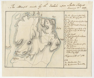
The attempt made by the rebels upon Staten Island January 15th 1780
19.
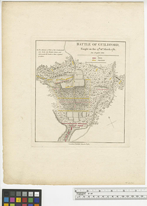
Battle of Guildford : fought on the 15th of March 1781
20.
Battle of Guildford fought on the 15 of March 1781
‹ Prev
Next ›
1
2
3
4
5
…
448
449