Toggle navigation
LMEC Home
Exhibitions
Georeferencing
Tools for Teachers
Collections
My Favorites
Sign Up / Log In
Search
Search the map portal
Map Collection
Map Collection
Map Sets
Search
Search
Search for
Search In
All Fields
Creator
Title
Subject
Place
Search All Digital Collections
Advanced Search
8694 Results
My Search
Start Over
More Like
commonwealth:tx31vw013
Remove constraint More Like: commonwealth:tx31vw013
Filter your Search
Place
North and Central America
5,926
United States
4,844
Massachusetts
2,079
Europe
1,396
Suffolk (county)
1,046
Boston
1,019
Canada
449
Asia
438
more
Place
»
Topic
Boston (Mass.)--Maps
586
United States--Maps
282
Real property--Massachusetts--Boston--Maps
175
Massachusetts--Maps
162
Landowners--Massachusetts--Boston--Maps
133
North America--Maps--Early works to 1800
103
New England--Maps
102
Europe--Maps
79
more
Topic
»
Date
Date range begin
–
Date range end
Current results range from
1482
to
2023
View distribution
Creator
United States. Hydrographic Office
595
O.H. Bailey & Co
148
Des Barres, Joseph F. W. (Joseph Frederick Wallet), 1722-1824
123
United States. Post Office Dept
120
Ptolemy, 2nd cent
100
Walling, Henry Francis, 1825-1888
94
Geological Survey (U.S.)
86
Jefferys, Thomas, -1771
85
more
Creator
»
Format
Maps/Atlases
8,634
Manuscripts
215
Prints
56
Books
36
Objects/Artifacts
10
Drawings/Illustrations
8
Posters
5
Georeferenced
Yes
869
No
7,825
Collection
Norman B. Leventhal Map & Education Center Collection
8,694
Boston and New England Maps
2,233
Urban Maps
2,023
Maritime Charts and Atlases
1,082
American Revolutionary War-Era Maps
616
Boston Redevelopment Authority Collection
87
Available to use
No known restrictions
8,552
Creative Commons license
47
Search Constraints
Sort by relevance
relevance
title
date (asc)
date (desc)
Number of results to display per page
20 per page
10
per page
20
per page
50
per page
100
per page
View results as:
grid view
map view
Search Results
1.
Ahii and Manhii or Peacock and Wilsons Islands
2.
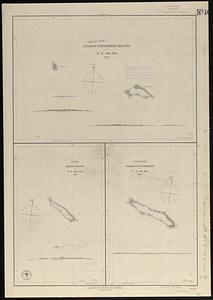
Deans, Krusensterns, and Lazareff Islands
3.
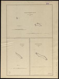
Deans, Krusensterns, and Lazareff Islands
4.
Kawahe or Vincennes Island, Paumoto Group ; Raraka Island, Paumotu Group
5.
Kawahe or Vincennes Island, Paumoto Group ; Raraka Island, Paumotu Group
6.
King Georges Group ; Aratica or Carlshoff Island
7.
Low Archipelago or Paumotu Group
8.
St. Pablo, Paumotu Group ; Nukutipipi or Margaret Island, Paumotu Group ; Heretua or Archangel of Quiros, Paumotu Group ; Teku...
9.
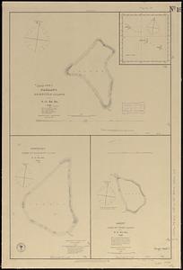
Disappointment Group ; Reao or Serle Island ; Pukaruha or Clermont-Tonnere
10.
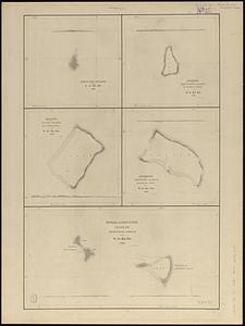
Disappointment Group ; Serle Island ; Clermont-Tonnere
11.
Apolima, Samoan Group ; Harbour of Oafonu, Isld. of Tutuila, north side ; Harbour of Aur, Isld. of Tutuila, north side ;...
12.
Bay of Massefao, island of Tutuila ; Bay of Fagaitui, island of Tutuila ; Sketch of Aluau Bay, 1839 ; Sketch of Anuu Island, 1839
13.
Fakaafo or Bowditch Island ; Nuku-Nono or Duke of Clarence Island ; Oatáfu or Duke of York Island
14.
Fakaafo or Bowditch Island ; Nuku-Nono or Duke of Clarence Island ; Oatáfu or Duke of York Island
15.
Harbour of Mataatu, north side, island of Savaii ; Harbour of Apia, north side, island of Upolu ; roadstead between Laulii and...
16.
Harbour of Sanaapu, island of Upolu ; Harbour of Falifa, island of Upolu
17.
Hudsons Island ; Maraki or Matthews Island, Kingsmill Group ; Maiana or Halls Island, Kingsmill Group ; Apamama or Hoppers...
18.
Island of Savaii, Samoan Group
19.
Island of Upolu, Samoan Group
20.
Islands of Manua, Ofoo & Oloosinga, Samoan Group ; Island of Tutuila, Samoan Group
‹ Prev
Next ›
1
2
3
4
5
…
434
435