Toggle navigation
LMEC Home
Exhibitions
Georeferencing
Tools for Teachers
Collections
My Favorites
Sign Up / Log In
Search
Search the map portal
Map Collection
Map Collection
Map Sets
Search
Search
Search for
Search In
All Fields
Creator
Title
Subject
Place
Search All Digital Collections
Advanced Search
8713 Results
My Search
Start Over
More Like
commonwealth:qz20zv082
Remove constraint More Like: commonwealth:qz20zv082
Filter your Search
Place
North and Central America
5,944
United States
4,856
Massachusetts
2,086
Europe
1,396
Suffolk (county)
1,047
Boston
1,020
Canada
450
Asia
438
more
Place
»
Topic
Boston (Mass.)--Maps
587
United States--Maps
282
Real property--Massachusetts--Boston--Maps
175
Massachusetts--Maps
170
Landowners--Massachusetts--Boston--Maps
133
New England--Maps
104
North America--Maps--Early works to 1800
103
Europe--Maps
79
more
Topic
»
Date
Date range begin
–
Date range end
Current results range from
1482
to
2023
View distribution
Creator
United States. Hydrographic Office
595
O.H. Bailey & Co
148
Des Barres, Joseph F. W. (Joseph Frederick Wallet), 1722-1824
123
United States. Post Office Dept
120
Ptolemy, 2nd cent
100
Walling, Henry Francis, 1825-1888
94
Geological Survey (U.S.)
90
Jefferys, Thomas, -1771
85
more
Creator
»
Format
Maps/Atlases
8,653
Manuscripts
216
Prints
56
Books
36
Objects/Artifacts
10
Drawings/Illustrations
8
Posters
5
Georeferenced
Yes
872
No
7,841
Collection
Norman B. Leventhal Map & Education Center Collection
8,701
Boston and New England Maps
2,239
Urban Maps
2,023
Maritime Charts and Atlases
1,083
American Revolutionary War-Era Maps
626
Boston Redevelopment Authority Collection
87
David Judkins Weaver Papers
6
American Antiquarian Society Collection
5
more
Collection
»
Available to use
No known restrictions
8,559
Creative Commons license
48
Search Constraints
Sort by relevance
relevance
title
date (asc)
date (desc)
Number of results to display per page
20 per page
10
per page
20
per page
50
per page
100
per page
View results as:
grid view
map view
Search Results
2481.
Geologic map of copper range from Gratiot to La Salle, Michigan
2482.
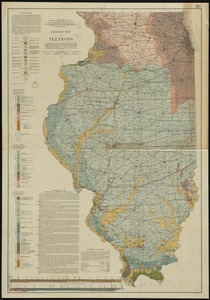
Geologic map of Illinois
2483.
Geologic map of Kentucky : showing oil and gas pools and pipelines and the eastern and western coalfields
2484.
Geologic map of Ohio
2485.
Geologic map of Oklahoma
2486.
Geologic reconnaissance map of Mindanao
2487.
Geologic sections in T. 56 N., R. 33 W.
2488.
Geologic sections in T. 56 N., Rs. 32 and 33 W.
2489.
Geological and topographical map of Crows Nest coal-fields, East Kootenay District, B.C. ; Geological sketch map of part of the...
2490.
Geological and topographical map of the anthracite fields of Pennsylvania : constructed from original explorations and surveys
2491.
Geological and topographical maps of oil lands of Japan
2492.
A geological and topographical rough survey map of the Hinckley Coal Lands near Warsaw, Coshocton County, Ohio
2493.
A geological and topographical sketch map of the New York and Westmoreland Gas Coal Company's lands, at Manor Sta., Westm'd...
2494.
Geological map Allegheny River Valley accompanying report of Allegheny River survey Nov. 25, 1898
2495.
Geological map of a portion of West Texas : showing parts of Brewster, Presidio, Jeff. Davis, and El Paso counties, and south...
2496.
Geological map of Essex County, Massachusetts
2497.
Geological map of Iceland
2498.
Geological map of Indiana, showing location of stone quarries and natural gas and oil areas
2499.
Geological map of Massachusetts
2500.
A geological map of Ohio
‹ Prev
Next ›
1
2
…
121
122
123
124
125
126
127
128
129
…
435
436