Geological map of Indiana, showing location of stone quarries and natural gas and oil areas
Item Information
- Title:
- Geological map of Indiana, showing location of stone quarries and natural gas and oil areas
- Description:
-
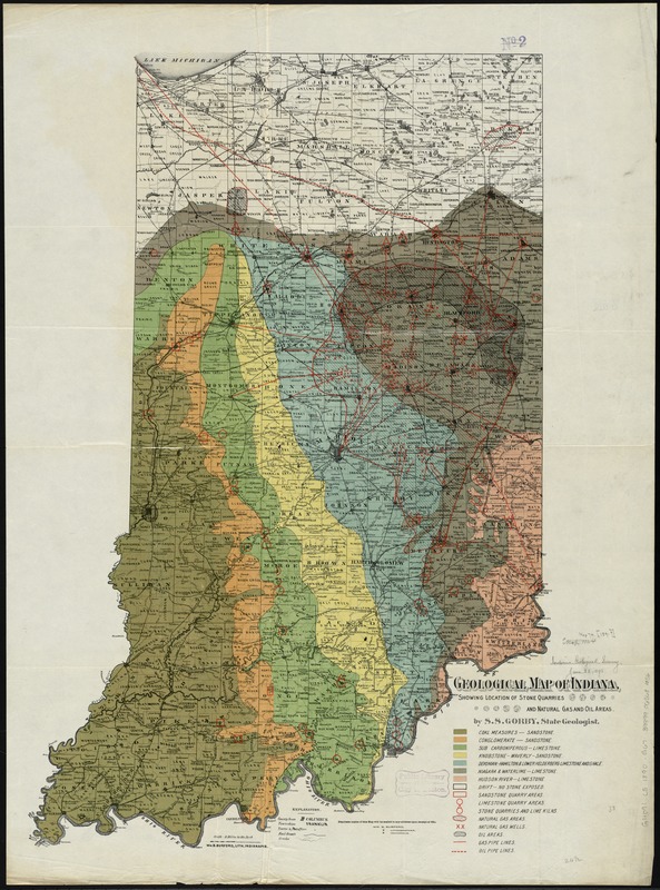
Geological maps could also be used to indicate location of oil and gas deposits, as seen by this late-19th-century example. This map of Indiana shows not only where coal and other industrial minerals are located, but also indicates sites of oil and natural gas basins and wells, and the pipeline systems in which to transport those resources. As was the case in West Virginia, oil and gas were first discovered in Indiana in the mid-19th century during salt mining operations. The area produced millions of barrels of oil until the early 20th century.
- Creator:
- Gorby, S. S.
- Name on Item:
-
by S.S. Gorby, State Geologist.
- Date:
-
[1890?–1899?]
- Format:
-
Maps/Atlases
- Location:
-
Boston Public Library
Norman B. Leventhal Map & Education Center - Collection (local):
-
Norman B. Leventhal Map & Education Center Collection
- Subjects:
-
Geology--Indiana--Maps
Natural gas--Indiana--Maps
Petroleum--Indiana--Maps
Indiana--Maps
- Places:
-
Indiana
- Extent:
- 1 map : col. ; 89 x 64 cm.
- Terms of Use:
-
No known copyright restrictions.
No known restrictions on use.
- Publisher:
-
Indianapolis, Ind :
Dept. of Geology and Natural Resources
- Scale:
-
Scale [ca. 1:570,240]. 9 miles to the inch
- Language:
-
English
- Notes:
-
Plate from 19th Annual Report.
"Wm. B. Burford, Lith., Indianapolis."
- Notes (exhibitions):
-
Exhibited: "Beneath Our Feet: Mapping the World Below" organized by the Norman B. Leventhal Map Center at the Boston Public Library, 2017-2018.
- Identifier:
-
06_01_011158
- Call #:
-
G4091.C5 1890 .G67
- Barcode:
-
39999065681056