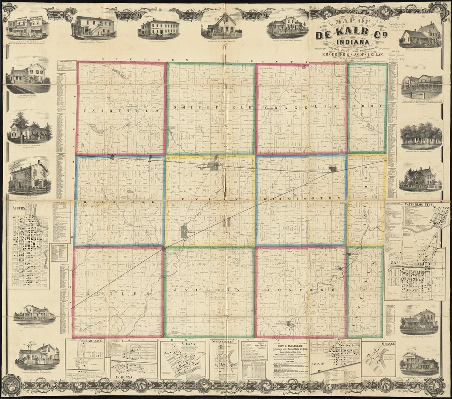
Map of De Kalb Co., Indiana
Item Information
- Title:
- Map of De Kalb Co., Indiana
- Creator:
- Gerber, E. B.
- Name on Item:
-
from government & recent surveys, compiled, drawn, and published by E.B. Gerber & C.A.O. Mc. Clellan ; engd. by Worley & Bracher.
- Date:
-
1863
- Format:
-
Maps/Atlases
- Location:
-
Boston Public Library
Norman B. Leventhal Map & Education Center - Collection (local):
-
Norman B. Leventhal Map & Education Center Collection
- Subjects:
-
Landowners--Indiana--De Kalb County--Maps
Real property--Indiana--De Kalb County--Maps
Indiana--Maps
- Places:
-
IndianaDe Kalb (county)
- Extent:
- 1 map on 4 sheets : hand color ; 103 x 124 cm.
- Terms of Use:
-
No known copyright restrictions.
No known restrictions on use.
- Publisher:
-
[Philadelphia] ; Phila. :
E.B. Gerber & C.A.O. Mc. Clellan, ; Printed by F. Bourquin & Co.
- Scale:
-
Scale approximately 1:37,000
- Language:
-
English
- Notes:
-
Entered according to Act of Congress in the year 1863 by E.B. Gerber & C.A.O. Mc. Clellan in the Clerks Office of the district court of the dist. of Indiana.
Includes business directories, list of county officers, distance table, statistical table (1862), views of public, residential, and commercial buildings.
Insets: Auburn -- Lawrence -- Corunna -- Vienna -- Spencerville -- Arvis -- Orange -- Waterloo City.
BPL copy assembled, sectioned in 4, and mounted on cloth.
- Identifier:
-
06_01_011157
- Call #:
-
G4093.D25 1863 .G47
- Barcode:
-
39999065681023
- LCCN:
-
2013593194