Toggle navigation
LMEC Home
Exhibitions
Georeferencing
Tools for Teachers
Collections
My Favorites
Sign Up / Log In
Search
Search the map portal
Map Collection
Map Collection
Map Sets
Search
Search
Search for
Search In
All Fields
Creator
Title
Subject
Place
Search All Digital Collections
Advanced Search
8773 Results
My Search
Start Over
More Like
commonwealth:qj72rq70n
Remove constraint More Like: commonwealth:qj72rq70n
Filter your Search
Place
North and Central America
6,004
United States
4,922
Massachusetts
2,088
Europe
1,396
Suffolk (county)
1,124
Boston
1,097
Canada
449
Asia
438
more
Place
»
Topic
Boston (Mass.)--Maps
606
United States--Maps
282
Real property--Massachusetts--Boston--Maps
253
Landowners--Massachusetts--Boston--Maps
170
Massachusetts--Maps
162
City planning--Massachusetts--Boston--Maps
108
North America--Maps--Early works to 1800
103
New England--Maps
102
more
Topic
»
Date
Date range begin
–
Date range end
Current results range from
1482
to
2023
View distribution
Creator
United States. Hydrographic Office
595
O.H. Bailey & Co
148
Des Barres, Joseph F. W. (Joseph Frederick Wallet), 1722-1824
123
United States. Post Office Dept
120
Boston Redevelopment Authority
110
Ptolemy, 2nd cent
100
Walling, Henry Francis, 1825-1888
94
Geological Survey (U.S.)
86
more
Creator
»
Format
Maps/Atlases
8,713
Manuscripts
215
Prints
56
Books
36
Objects/Artifacts
10
Drawings/Illustrations
8
Posters
5
Georeferenced
Yes
869
No
7,904
Collection
Norman B. Leventhal Map & Education Center Collection
8,695
Boston and New England Maps
2,276
Urban Maps
2,066
Maritime Charts and Atlases
1,083
American Revolutionary War-Era Maps
616
Boston Redevelopment Authority Collection
129
Massachusetts Real Estate Atlases
35
Applied Geographics, Inc. Records
1
Available to use
No known restrictions
8,596
Creative Commons license
47
Search Constraints
Sort by relevance
relevance
title
date (asc)
date (desc)
Number of results to display per page
20 per page
10
per page
20
per page
50
per page
100
per page
View results as:
grid view
map view
Search Results
4701.
Map showing elevators in Manitoba, Saskatchewan and Alberta
4702.
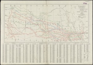
Map showing horse rail roads and the surface steam roads with 104 stations in and around Boston : including 91 surface steam...
4703.
Map showing in five degrees of density the distribution of woodland within the territory of the United States, 1873
4704.
Map showing Indian reservations within the limits of the United States, 1901
4705.
Map showing Indian reservations within the limits of the United States, 1903
4706.
Map showing Indian reservations within the limits of the United States, 1904
4707.
Map showing Indian reservations within the limits of the United States, 1905
4708.
Map showing Indian reservations within the limits of the United States, 1906
4709.
Map showing Japanese-Chinese warfre [sic] now in Shanghai
4710.
Map showing lines of the Bell telephone companies in the United States and Canada : July 1st, 1904
4711.
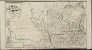
Map showing location of the Chicago & Northwestern Railway with its branches & connections through Illinois, Iowa, Nebraska,...
4712.
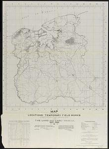
Map showing locations of temporary field works erected by the Spanish for the land defense of Havana, 1897-1898
4713.
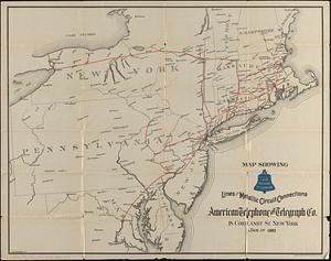
Map showing long distance telephone lines and metallic circuit connections
4714.
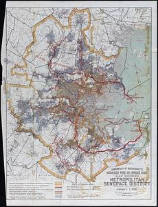
Map showing Metropolitan Sewerage District : January 1, 1921
4715.
Map showing metropolitan sewerage district : January 1, 1910
4716.
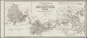
Map showing metropolitan water district, Wachusett, Sudbury and Cochituate watersheds and locations of reservoirs, aqueducts...
4717.
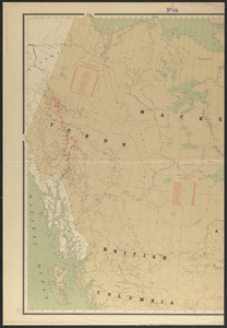
Map showing mounted police stations in north-western Canada
4718.
Map showing mounted police stations in the North West Territories
4719.
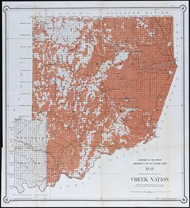
Map showing progress of allotment in Creek Nation
4720.
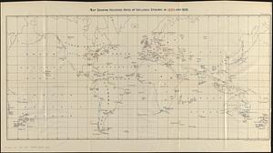
Map showing recorded dates of influenza epidemic in 1889 and 1890
‹ Prev
Next ›
1
2
…
232
233
234
235
236
237
238
239
240
…
438
439


![Map showing Japanese-Chinese warfre [sic] now in Shanghai](https://bpldcassets.blob.core.windows.net/derivatives/images/commonwealth:9s161h819/image_thumbnail_300.jpg)