Map showing recorded dates of influenza epidemic in 1889 and 1890
Item Information
- Title:
- Map showing recorded dates of influenza epidemic in 1889 and 1890
- Cartographer:
- Parsons, H. Franklin (Henry Franklin), 1846-1913
- Date:
-
[1891]
- Format:
-
Maps/Atlases
- Genre:
-
World maps
Thematic maps
- Location:
-
Boston Public Library
Norman B. Leventhal Map & Education Center - Collection (local):
-
Norman B. Leventhal Map & Education Center Collection
- Subjects:
-
Influenza--Maps
- Places:
-
World
- Extent:
- 1 map : color ; 34 x 73 cm
- Terms of Use:
-
No known copyright restrictions.
No known restrictions on use.
- Publisher:
-
[London] :
[Eyre & Spottiswoode]
- Scale:
-
Scale approximately 1:60,000,000 at the equator
- Language:
-
English
- Notes:
-
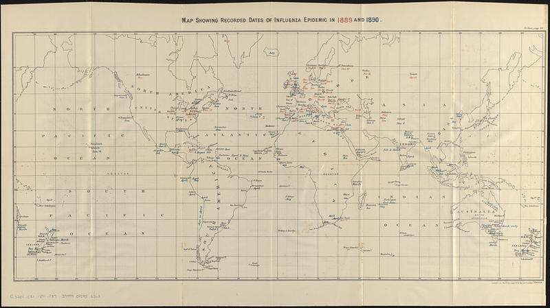
Indicates the dates of the first recorded case of influenza in locations around the world during the 1889-1890 flu pandemic.
From Report on the influenza epidemic of 1889-90 / by Dr. Parsons (London : Eyre & Spottiswoode, 1891).
"To face page 49."--Upper right margin.
- Notes (date):
-
This date is inferred.
- Identifier:
-
06_01_017350
- Call #:
-
G3201.E51 1891 .P37
- Barcode:
-
39999085956363


