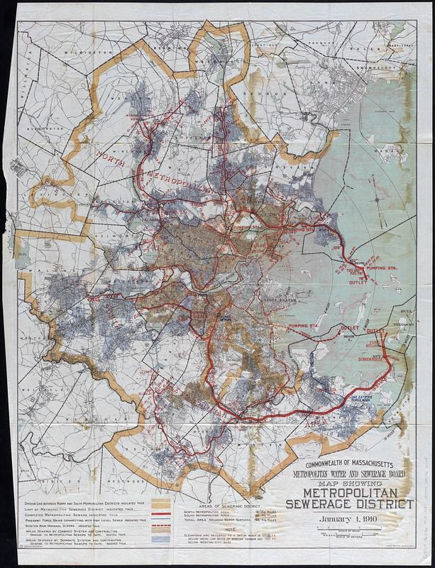
Map showing metropolitan sewerage district : January 1, 1910
Item Information
- Title:
- Map showing metropolitan sewerage district : January 1, 1910
- Cartographer:
- Massachusetts. Metropolitan Sewerage Commission
- Copyright claimant:
- Geo. H. Walker & Co.
- Printer:
- Wright & Potter
- Copyright holder:
- Walker Lith. & Pub. Co.
- Name on Item:
-
Commonwealth of Massachusetts Metropolitan Water and Sewerage Board
- Date:
-
[1910]
- Format:
-
Maps/Atlases
- Location:
-
Boston Public Library
Norman B. Leventhal Map & Education Center - Collection (local):
-
Norman B. Leventhal Map & Education Center Collection
- Subjects:
-
Boston Metropolitan Area (Mass.)--Maps
Sewerage--Massachusetts--Boston Metropolitan Area--Maps
Sanitary districts--Massachusetts--Boston Metropolitan Area--Maps
- Places:
-
MassachusettsSuffolk (county)Boston
- Extent:
- 1 map : color ; 77 x 59 cm
- Terms of Use:
-
No known copyright restrictions.
No known restrictions on use.
- Publisher:
-
[Boston] :
[Wright & Potter Printing Co.]
- Scale:
-
Scale approximately 1:53,000
- Language:
-
English
- Notes:
-
Relief shown by spot heights.
Detached from Ninth annual report of the Metropolitan Water and Sewerage Board for the year 1909 (Boston : Wright & Potter Printing Co., 1910).
- Notes (date):
-
This date is inferred.
- Identifier:
-
06_01_018356
- Call #:
-
G3764.B6N46 1910 .M37
- Barcode:
-
39999085966685

![Boston personal income ; Boston personal income [and] residential population density](https://bpldcassets.blob.core.windows.net/derivatives/images/commonwealth:fn107c409/image_thumbnail_300.jpg)

