Toggle navigation
LMEC Home
Exhibitions
Georeferencing
Tools for Teachers
Collections
My Favorites
Sign Up / Log In
Search
Search the map portal
Map Collection
Map Collection
Map Sets
Search
Search
Search for
Search In
All Fields
Creator
Title
Subject
Place
Search All Digital Collections
Advanced Search
487 Results
My Search
Start Over
More Like
commonwealth:q524nb76h
Remove constraint More Like: commonwealth:q524nb76h
Filter your Search
Place
North and Central America
426
United States
300
New York
40
Florida
19
Canada
17
Alabama
15
Chatham (county)
15
Savannah
13
more
Place
»
Topic
Manuscript maps--Early works to 1800
92
Manuscript maps
21
Gulf Coast (U.S.)--Maps, Manuscript--Early works to 1800
12
Fortification--New York (State)--New York--Maps--Early works to 1800
11
Nautical charts--Delaware Bay (Del. and N.J.)--Early works to 1800
10
New York (N.Y.)--Buildings, structures, etc--Maps, Manuscript--Early works to 1800
9
New York (N.Y.)--Maps, Manuscript--Early works to 1800
8
Saratoga Campaign, N.Y., 1777--Maps, Manuscript--Early works to 1800
8
more
Topic
»
Date
Date range begin
–
Date range end
Current results range from
1700
to
1899
View distribution
Creator
Hills, John, (Surveyor)
18
Montrésor, John, 1736-1799
16
Bingham, William, 1752-1804
12
Adlum, John, 1759-1836
10
Washington, George, 1732-1799
9
Faden, William, 1749-1836
7
Morgan, Benjamin, (Draftsman)
7
Wangenheim, Friedrich Adam Julius von
7
more
Creator
»
Format
Maps/Atlases
485
Manuscripts
475
Objects/Artifacts
2
Georeferenced
Yes
5
No
482
Collection
American Revolutionary War-Era Maps
485
Library of Congress Collection
480
Maritime Charts and Atlases
37
Urban Maps
15
Norman B. Leventhal Map & Education Center Collection
6
Richard H. Brown Revolutionary War Map Collection at Mount Vernon
1
Available to use
Creative Commons license
481
No known restrictions
6
Search Constraints
Sort by relevance
relevance
title
date (asc)
date (desc)
Number of results to display per page
20 per page
10
per page
20
per page
50
per page
100
per page
View results as:
grid view
map view
Search Results
1.
Baye de la Delaware avec les ports, sondes, dangers, bancs, &c. depuis les caps jusqu'a Philadelphie : d'après la carte de...
2.
Plano de la Bahia de la Ware y entrada de Filadelfie
3.
Plano de Philadelphia
4.
Carte de la Baye et Riviere de Délaware : contenant une éxacte et entiére description des rivages, criques, havres, sondes,...
5.
A chart of Delawar Bay, with soundings and nautical observations
6.
A chart of Delaware Bay and River, containing a full and exact description of the shores, creeks, harbours, soundings, shoals,...
7.
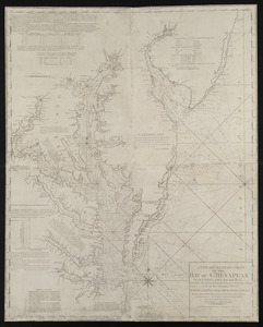
A new and accurate chart of the Bay of Chesapeak including Delaware Bay with all the shoals, channels, islands, entrances,...
8.
A new and accurate chart of the Bay of Chesapeak including Delaware Bay with all the shoals, channels, islands, entrances,...
9.
A new and accurate chart of the Bay of Chesapeak including Delaware Bay with all the shoals, channels, islands, entrances,...
10.
Virginia, Maryland, Pennsilvania, east & west New Jarsey
11.
1st. & 2d. position of that part of the army engaged on the 19th Sept. 1777 : 3d & 4th postn. Sept. 19
12.
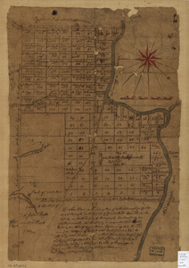
20 tracts, Charleston
13.
20 tracts, Tioga County
14.
The Above is a plan of the town of Cabot, State of Vermont
15.
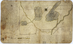
The above plan is a discription of a new township called Royalsborough in the county of Cumberland : bounded southeasterly on...
16.
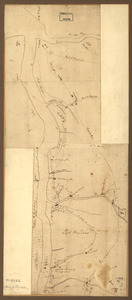
The above plan is a discription of a new township containing the quantity of seven and a half mile of land & water, granted by...
17.
An accurate map of His Majesty's Province of New-Hampshire in New England & all the adjacent country northward to the River St....
18.
Amboy to Elizabethtown
19.
Armée de Rochambeau, 1782 : Carte des environs de Williamsburg en Virginie où les armées françoise et américaine ont...
20.
Armstrong County
‹ Prev
Next ›
1
2
3
4
5
…
24
25