Toggle navigation
LMEC Home
Exhibitions
Georeferencing
Tools for Teachers
Collections
My Favorites
Sign Up / Log In
Search
Search the map portal
Map Collection
Map Collection
Map Sets
Search
Search
Search for
Search In
All Fields
Creator
Title
Subject
Place
Search All Digital Collections
Advanced Search
541 Results
My Search
Start Over
More Like
commonwealth:q524n816n
Remove constraint More Like: commonwealth:q524n816n
Filter your Search
Place
North and Central America
476
United States
337
New York
42
Canada
26
Florida
20
Mississippi
18
Alabama
17
Chatham (county)
16
more
Place
»
Topic
Manuscript maps--Early works to 1800
138
Manuscript maps
21
Gulf Coast (U.S.)--Maps, Manuscript--Early works to 1800
12
Fortification--New York (State)--New York--Maps--Early works to 1800
11
George, Lake (N.Y. : Lake)--Maps, Manuscript--Early works to 1800
11
New York (N.Y.)--Buildings, structures, etc--Maps, Manuscript--Early works to 1800
9
United States--History--French and Indian War, 1754-1763--Maps, Manuscript--Early works to 1800
9
New York (N.Y.)--Maps, Manuscript--Early works to 1800
8
more
Topic
»
Date
Date range begin
–
Date range end
Current results range from
1700
to
1899
View distribution
Creator
Hills, John, (Surveyor)
18
Montrésor, John, 1736-1799
16
Dumont de Montigny
14
George, III, King of Great Britain, 1738-1820
13
George, IV, King of Great Britain, 1762-1830
13
Bingham, William, 1752-1804
12
Adlum, John, 1759-1836
10
Washington, George, 1732-1799
9
more
Creator
»
Format
Maps/Atlases
539
Manuscripts
535
Objects/Artifacts
2
Georeferenced
Yes
6
No
535
Collection
American Revolutionary War-Era Maps
535
Library of Congress Collection
485
Newberry Library Collection
39
Maritime Charts and Atlases
33
Urban Maps
17
British Library Collection
14
Boston and New England Maps
4
Norman B. Leventhal Map & Education Center Collection
3
Available to use
Creative Commons license
499
No known restrictions
3
Search Constraints
Sort by relevance
relevance
title
date (asc)
date (desc)
Number of results to display per page
20 per page
10
per page
20
per page
50
per page
100
per page
View results as:
grid view
map view
Search Results
141.
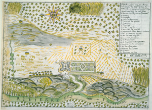
Plan de Savannah
142.
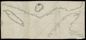
Plan du detroit de Belle Isle et du Golphe St. Laurent pour la coste du nord
143.
Plan du Fort des Yachoux, concession de Mgr. le duc de Belle Isle et associez, detruit 1729
144.
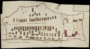
Plan du Fort du Sault de St. Louis et du village des sauvages Iroquois
145.
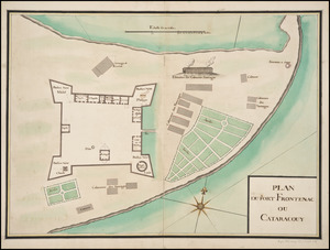
Plan du Fort Frontenac ou Cataracouy
146.
Plan du port et de la ville de Louisbourg : avec ses batteries et sa perspective, où est réprésenté les batteries faites...
147.
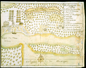
Plan du vieux Fort du Billoxi, 2 etablissement
148.
Plan d'une partie de la rade de Boston pour faire connaitre le dispositif de ses deffenses
149.
A plan of Becket protracted by a scale of 120 rods to an inch
150.
A plan of the bay and harbor of Boston : surveyed agreeably to the orders and instructions of the Right Honorable the Lords...
151.
Plan of the peninsula of Chesopeak [sic] Bay
152.
The world with all modern discoveries
153.
Ysla de Cuba
154.
1st. & 2d. position of that part of the army engaged on the 19th Sept. 1777 : 3d & 4th postn. Sept. 19
155.
20 tracts, Tioga County
156.
The Above is a plan of the town of Cabot, State of Vermont
157.
The above plan is a discription of a new township called Royalsborough in the county of Cumberland : bounded southeasterly on...
158.
The above plan is a discription of a new township containing the quantity of seven and a half mile of land & water, granted by...
159.
An accurate map of His Majesty's Province of New-Hampshire in New England & all the adjacent country northward to the River St....
160.
Amboy to Elizabethtown
‹ Prev
Next ›
1
2
…
4
5
6
7
8
9
10
11
12
…
27
28


![Plan of the peninsula of Chesopeak [sic] Bay](https://bpldcassets.blob.core.windows.net/derivatives/images/commonwealth:z603vn14c/image_thumbnail_300.jpg)