Toggle navigation
LMEC Home
Exhibitions
Georeferencing
Tools for Teachers
Collections
My Favorites
Sign Up / Log In
Search
Search the map portal
Map Collection
Map Collection
Map Sets
Search
Search
Search for
Search In
All Fields
Creator
Title
Subject
Place
Search All Digital Collections
Advanced Search
311 Results
My Search
Start Over
More Like
commonwealth:q524mv577
Remove constraint More Like: commonwealth:q524mv577
Filter your Search
Place
North and Central America
241
United States
166
New York
32
Suffolk (county)
32
Boston
30
Canada
28
North America
27
Barbados
11
more
Place
»
Topic
North America--Maps--Early works to 1800
18
Boston (Mass.)--History--Revolution, 1775-1783--Maps--Early works to 1800
16
Barbados--Maps--Early works to 1800
11
Vues d'optique
10
Gibraltar--History--Siege, 1779-1783--Maps--Early works to 1800
9
New York (N.Y.)--Pictorial works--Early works to 1800
9
United States--History--French and Indian War, 1754-1763--Maps--Early works to 1800
9
United States--Maps--Early works to 1800
9
more
Topic
»
Date
Date range begin
–
Date range end
Current results range from
1656
to
1799
View distribution
Creator
Faden, William, 1749-1836
33
Jefferys, Thomas, -1771
32
Le Rouge, Georges-Louis
23
Sayer, Robert, 1725-1794
22
Des Barres, Joseph F. W. (Joseph Frederick Wallet), 1722-1824
21
Korn, Christoph Heinrich, 1726-1783
11
Raspe, Gabriel Nicolaus, 1712-1785
11
Simcoe, John Graves, 1752-1806
10
more
Creator
»
Format
Maps/Atlases
268
Prints
32
Manuscripts
24
Drawings/Illustrations
9
Books
2
Georeferenced
Yes
14
No
297
Collection
American Revolutionary War-Era Maps
302
Richard H. Brown Revolutionary War Map Collection at Mount Vernon
293
Norman B. Leventhal Map & Education Center Collection
17
Maritime Charts and Atlases
5
Boston and New England Maps
4
Urban Maps
2
Newberry Library Collection
1
Available to use
Creative Commons license
293
No known restrictions
17
Search Constraints
Sort by relevance
relevance
title
date (asc)
date (desc)
Number of results to display per page
20 per page
10
per page
20
per page
50
per page
100
per page
View results as:
grid view
map view
Search Results
61.
Carte du port et havre de Boston avec les côtes adjacentes, dans laquel on a tracée les camps et les retranchemens occupé,...
62.
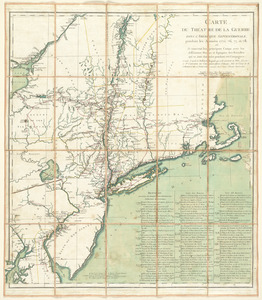
Carte du théatre de la guerre actuel entre les Anglais et les Treize Colonies Unies de l'Amerique Septentrionale
63.
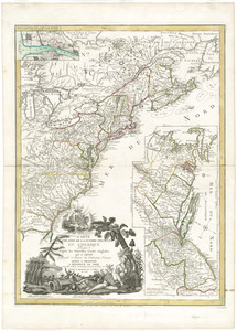
Carte du théatre de la guerre dans l'Amérique Septentrionale, pendant les années 1775, 76, 77, et 78 : où se trouvent les...
64.
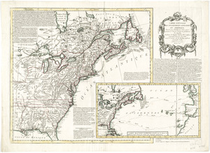
Carte du theatre de la guerre presente en Amerique
65.
Carte d'une partie du Nord Amerique dans la quelle se trouvent les isles et les provinces suivantes : l'Isle de la Terre-Neuve...
66.
Carte generale des colonies angloises dans l'Amerique Septentrionale pour l'intelligence de la guerre presente : d'apres des...
67.
Carte generale des treize Etats Unis, de l'Amerique septentrionale = Kaart van de dertien Verénigde Staaten, in Noord Amerika
68.
Carte nouvelle des posséssions angloises en Amérique : dressée pour l'intelligence de la guerre présente et divisée...
69.
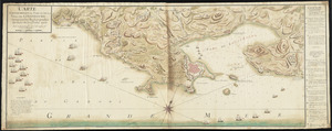
Carte topographique du port et de la ville de Louisbourg, assiegé par les Anglais pendant les mois de Juin, Juillet 1758
70.
Castle William : A view of New Castle with the Fort and light house on the entrance of the Pisquataqua River
71.
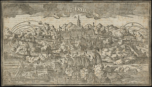
Charlestown
72.
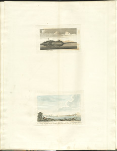
[Charlestown Promontory, the ruins of the town after the Battle of Bunker Hill and General Howe's encampment]
73.
Chart comprizing Greenland with the countries and islands about Baffin's and Hudson's Bays
74.
Chart containing the coasts of California, New Albion, and Russian discoveries to the north : with the peninsula of Kamchatka,...
75.
Chart containing the greater part of the South Sea to the south of the line, with islands dispersed thro' the same
76.
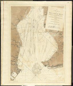
A chart of Delawar Bay, with soundings and nautical observations
77.
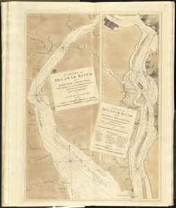
A chart of Delawar River from Bombay Hook to Ridley Creek, with soundings &c taken by Lt. Knight of the Navy
78.
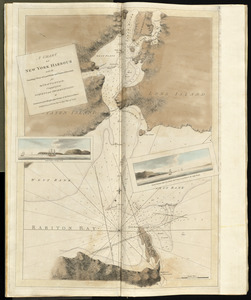
A chart of New York Harbour with the soundings views of land marks and nautical directions : for the use of pilotage
79.
A chart of North and South America, including the Atlantic and Pacific Oceans, with the nearest coasts of Europe, Africa and Asia
80.
Chart of South America, comprehending the West Indies, with the adjacent islands, in the Southern Ocean, and South Sea
‹ Prev
Next ›
1
2
3
4
5
6
7
8
…
15
16


![[Charlestown Promontory, the ruins of the town after the Battle of Bunker Hill and General Howe's encampment]](https://bpldcassets.blob.core.windows.net/derivatives/images/commonwealth:dz010v65g/image_thumbnail_300.jpg)