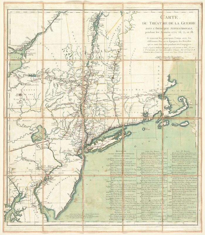
Carte du théatre de la guerre dans l'Amérique Septentrionale, pendant les années 1775, 76, 77, et 78 : où se trouvent les principaux camps avec les différentes places et epoques des batailles qui se sont données pendant ces campagnes
This map is also available in American Revolutionary Geographies Online (ARGO), a collections portal especially built for material relating to the American Revolutionary War Era. Visit ARGO to learn more about this item and explore the historical geography of North America in the late eighteenth century.
Item Information
- Title:
- Carte du théatre de la guerre dans l'Amérique Septentrionale, pendant les années 1775, 76, 77, et 78 : où se trouvent les principaux camps avec les différentes places et epoques des batailles qui se sont données pendant ces campagnes
- Creator:
- Capitaine du Chesnoy, Michel, 1746-1804
- Publisher:
- Perrier, fl. 1760-1824
- Publisher:
- Fortin, J. (Jean), 1740-1817
- Name on Item:
-
gravée d'après le dessein original qui a été présente au Roi, fait par le Sr. Capitaine du Chesnoy, officier Français, Aide de Camp de M. le Marquis de la Fayette, servant alors dans l'armée Américaine.
- Date:
-
[1778]
- Format:
-
Maps/Atlases
- Location:
- George Washington's Mount Vernon
- Collection (local):
-
Richard H. Brown Revolutionary War Map Collection at Mount Vernon
- Subjects:
-
Northeastern States--History--18th century--Maps--Early works to 1800
- Places:
-
Northeastern United States (area)
- Extent:
- 1 map : hand col. ; 73 x 67 cm.
- Terms of Use:
-
No known copyright restrictions.
This work is licensed for use under a Creative Commons Attribution Non-Commercial Share Alike License (CC BY-NC-SA).

- Publisher:
-
Paris :
Chez Perrier ; Chez Fortin
- Scale:
-
Scale [ca. 1:1,050,000]
- Language:
-
French
English
- Catalog Record:
-
MVLA record
- Notes:
-
Prime meridian: Washington, D.C.
Relief shown by hachures.
Includes indexed chronology of "Renvois relatifs aux époques des différentes opérations militaires."
Indexed chronology and statements of attribution in French. Map place names in English.
- Notes (date):
-
This date is inferred.
- Identifier:
-
06_01_009578


![[A map of part of Pennsylvania & Maryland intended to shew, at one view, the several places proposed for opening a communication between the waters of the Delaware & Chesopeak Bays]](https://bpldcassets.blob.core.windows.net/derivatives/images/commonwealth:z603vt12v/image_thumbnail_300.jpg)

