Toggle navigation
LMEC Home
Exhibitions
Georeferencing
Tools for Teachers
Collections
My Favorites
Sign Up / Log In
Search
Search the map portal
Map Collection
Map Collection
Map Sets
Search
Search
Search for
Search In
All Fields
Creator
Title
Subject
Place
Search All Digital Collections
Advanced Search
388 Results
My Search
Start Over
More Like
commonwealth:q524mv18j
Remove constraint More Like: commonwealth:q524mv18j
Filter your Search
Place
North and Central America
304
United States
256
Canada
52
North America
38
New York
31
Suffolk (county)
31
Boston
29
Charleston (county)
10
more
Place
»
Topic
United States--Maps--Early works to 1800
103
North America--Maps--Early works to 1800
29
Canada--Maps--Early works to 1800
28
Boston (Mass.)--History--Revolution, 1775-1783--Maps--Early works to 1800
16
United States--History--Revolution, 1775-1783--Maps--Early works to 1800
12
Vues d'optique
10
Gibraltar--History--Siege, 1779-1783--Maps--Early works to 1800
9
New York (N.Y.)--Pictorial works--Early works to 1800
9
more
Topic
»
Date
Date range begin
–
Date range end
Current results range from
1707
to
1830
View distribution
Creator
Faden, William, 1749-1836
38
Jefferys, Thomas, -1771
32
Le Rouge, Georges-Louis
23
Des Barres, Joseph F. W. (Joseph Frederick Wallet), 1722-1824
21
Sayer, Robert, 1725-1794
20
Robert Sayer and John Bennett (Firm)
12
Korn, Christoph Heinrich, 1726-1783
11
Raspe, Gabriel Nicolaus, 1712-1785
11
more
Creator
»
Format
Maps/Atlases
345
Prints
32
Manuscripts
23
Drawings/Illustrations
9
Books
2
Georeferenced
Yes
15
No
373
Collection
American Revolutionary War-Era Maps
377
Richard H. Brown Revolutionary War Map Collection at Mount Vernon
293
MacLean Collection Map Library
43
Norman B. Leventhal Map & Education Center Collection
29
New York Public Library Collection
15
Boston and New England Maps
4
New-York Historical Society Collection
4
Mapping Boston Collection
2
more
Collection
»
Available to use
Creative Commons license
312
No known restrictions
31
Search Constraints
Sort by relevance
relevance
title
date (asc)
date (desc)
Number of results to display per page
20 per page
10
per page
20
per page
50
per page
100
per page
View results as:
grid view
map view
Search Results
321.
Position der Koenigl;Grosbrittanischen und derer vereinigten provinzial armée in New York und dem Jerseys in Nord America im...
322.
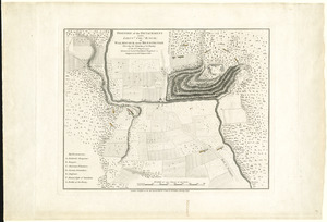
Position of the detachment under Lieut. Col. Baum, at Walmscock near Bennington shewing the attacks of the enemy on the 16th...
323.
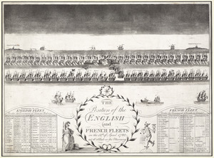
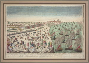
The position of the English and French fleets on the 12th of April 1782 at 10 oclock in the morning
324.
La premiere representation de les X batteries flottantes
325.
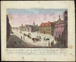
Prospect der grossen plazes gegn der alten Sud Kirche der Presbiterianer zu Boston = : Vuë de la Rue grande vers l'Eglise du...
326.
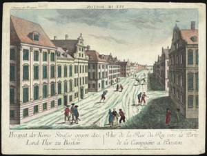
Prospect der König Strasse gegen das land thor zu Boston = : Vuë de la Rue du Roi vers la porte de la campagne a Boston
327.
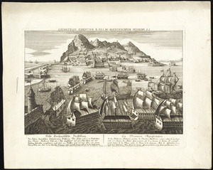
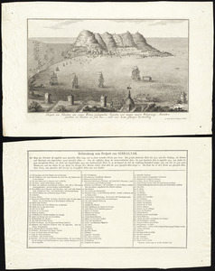
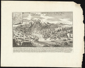
Prospect von Gibraltar mit seinen werken, umliegenden gegenden und iezigen neuern belagerungs anstalten : gezeichnet vor...
328.
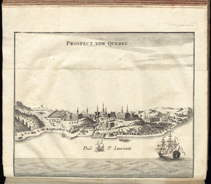
Prospect von Quebec
329.
A prospective view of the battle fought near Lake George, on the 8th of Sepr. 1755, between 2000 English, with 250 Mohawks,...
330.
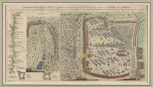
Province de New-Jersey divisée en est et ouest nomée vulgairement les Jerseys
331.
The province of New Jersey, divided into east and west, commonly called the Jerseys
332.
Rade et port de Plaisance -- Le Port d'Anapolis dans l'Acadie -- Port de Boston dans la Nouvlle. Angleterre
333.
Reddition de l'armée Angloises commandée par Mylord Comte de Cornwallis aux armees combinées des Etats Unis de l'Amerique et...
334.
Relation von der vergeblichen belagrung der haupt vestung Gibraltar : anno 1782 von 13 bis 17 sbre
335.
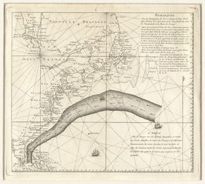
Remarques sur la navigation de terre-neuve à New-York afin d'eviter les courrants et les bas-fonds au sud de Nantuckett et du...
336.
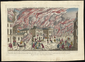
Représentation du feu terrible à Nouvelle Yorck, que les Américains ont allumé pendant la nuit du 19 Septembre 1776 ... et...
337.
A representation, of the sea fight, on the 5th of Sepr. 1781, between Rear Admiral Graves and the Count de Grasse
338.
Schauplatz des Kriegs zwischen Engelland und seinen Collonien in America
339.
The seat of action, between the British and American forces : or an authentic plan of the western part of Long Island, with the...
340.
The seat of war in New England, by an American volunteer : with the marches of the several corps sent by the Colonies towards...
‹ Prev
Next ›
1
2
…
13
14
15
16
17
18
19
20