Toggle navigation
LMEC Home
Exhibitions
Georeferencing
Tools for Teachers
Collections
My Favorites
Sign Up / Log In
Search
Search the map portal
Map Collection
Map Collection
Map Sets
Search
Search
Search for
Search In
All Fields
Creator
Title
Subject
Place
Search All Digital Collections
Advanced Search
303 Results
My Search
Start Over
More Like
commonwealth:q524mt93w
Remove constraint More Like: commonwealth:q524mt93w
Filter your Search
Place
North and Central America
237
United States
165
New York
31
Suffolk (county)
31
Boston
29
Canada
27
North America
27
Barbados
11
more
Place
»
Topic
North America--Maps--Early works to 1800
18
Boston (Mass.)--History--Revolution, 1775-1783--Maps--Early works to 1800
16
Barbados--Maps--Early works to 1800
11
Vues d'optique
10
Gibraltar--History--Siege, 1779-1783--Maps--Early works to 1800
9
New York (N.Y.)--Pictorial works--Early works to 1800
9
United States--History--French and Indian War, 1754-1763--Maps--Early works to 1800
9
United States--Maps--Early works to 1800
9
more
Topic
»
Date
Date range begin
–
Date range end
Current results range from
1686
to
1799
View distribution
Creator
Faden, William, 1749-1836
33
Jefferys, Thomas, -1771
28
Le Rouge, Georges-Louis
22
Des Barres, Joseph F. W. (Joseph Frederick Wallet), 1722-1824
21
Sayer, Robert, 1725-1794
19
Korn, Christoph Heinrich, 1726-1783
11
Raspe, Gabriel Nicolaus, 1712-1785
11
Simcoe, John Graves, 1752-1806
10
more
Creator
»
Format
Maps/Atlases
260
Prints
32
Manuscripts
24
Drawings/Illustrations
9
Books
2
Georeferenced
Yes
14
No
289
Collection
American Revolutionary War-Era Maps
297
Richard H. Brown Revolutionary War Map Collection at Mount Vernon
293
Norman B. Leventhal Map & Education Center Collection
9
Boston and New England Maps
4
Maritime Charts and Atlases
3
Urban Maps
2
Newberry Library Collection
1
Available to use
Creative Commons license
293
No known restrictions
9
Search Constraints
Sort by relevance
relevance
title
date (asc)
date (desc)
Number of results to display per page
20 per page
10
per page
20
per page
50
per page
100
per page
View results as:
grid view
map view
Search Results
1.
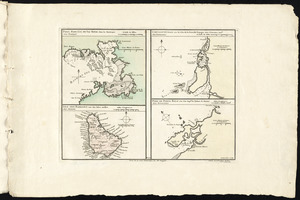
Port, baye cul de sac Royal dans la Martinique -- Isle des Barbades une des Isles Antilles -- Cartagene située sur le Côte de...
2.
Barbadoes
3.
Barbadoes
4.
Barbados
5.
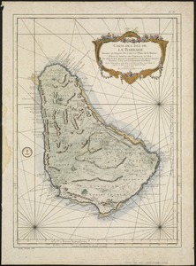
Carte de l'Isle de La Barbade : avec une description geographique de cette isle
6.
Dominia anglorum in præcipuis insulis Americæ ut sunt insula : S. Christophori, Antegoa, Iamaica, Barbados : nec non insulae...
7.
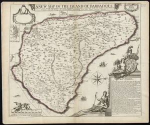
The island of Barbadoes : divided into its parishes, with the roads, paths, &c. according to an actual and accurate survey
8.
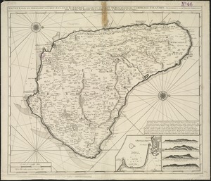
A new map of the Island of Barbadoes wherein every parish, plantation, watermill, windmill & cattlemill, is described with the...
9.
Nieuwe land en zeekaart van het eyland Barbados geleegen in West India onder de Caribesse Eylanden : afgeteekent na de nieuste...
10.
Plans des isles, rades, et ports de plusieurs lieux de l'Amérique : tirés de la Carte angloise de Mr. Popple publiée en 1733...
11.
The principall islands in America belonging to the English empire viz Iamaica, Barbados, Antegoa, St. Christophers & Bermudos
12.
[A map of part of Pennsylvania & Maryland intended to shew, at one view, the several places proposed for opening a...
13.
Abriss der stadt Gibraltar und der darinn befindlichen festen platze, nebst dem meerbusen von Algesiras
14.
An accurate map of His Majesty's province of New-Hampshire in New England : taken from actual surveys of all the inhabited...
15.
An accurate map of Staten Island : with that part of New York, Long Island and the Jerseys, which is the rendesvous of the two...
16.
An accurate map of the country round Boston in New England from the best authorities
17.
Action at Spencer's ordinary : June 26th. 1781
18.
Affair at Quintin's Bridge : 18th March 1778
19.
Allgemeine charte von Nord America als den sitz des krieges zwischen den Konigl. Engl. truppen u:den provinzialen
20.
Ambuscade of the Indians at Kingsbridge : August 31st. 1778
‹ Prev
Next ›
1
2
3
4
5
…
15
16


![[A map of part of Pennsylvania & Maryland intended to shew, at one view, the several places proposed for opening a communication between the waters of the Delaware & Chesopeak Bays]](https://bpldcassets.blob.core.windows.net/derivatives/images/commonwealth:z603vt12v/image_thumbnail_300.jpg)


