Toggle navigation
LMEC Home
Exhibitions
Georeferencing
Tools for Teachers
Collections
My Favorites
Sign Up / Log In
Search
Search the map portal
Map Collection
Map Collection
Map Sets
Search
Search
Search for
Search In
All Fields
Creator
Title
Subject
Place
Search All Digital Collections
Advanced Search
73 Results
My Search
Start Over
More Like
commonwealth:p841ck384
Remove constraint More Like: commonwealth:p841ck384
Filter your Search
Place
Canada
56
North and Central America
56
Quebec
29
Québec
28
New France
24
Saint Lawrence River
16
Province of New Brunswick
6
United States
6
more
Place
»
Topic
Québec (Québec)--Maps
27
New France--Maps
24
Seven Years' War, 1756-1763--Campaigns--Canada--Maps
20
Saint Lawrence River--Maps
17
United States--History--French and Indian War, 1754-1763--Maps
11
Canada--Maps--Early works to 1800
8
Fortification--Québec (Province)
7
Québec Campaign, Québec, 1759--Maps
7
more
Topic
»
Date
Date range begin
–
Date range end
Current results range from
1744
to
1817
View distribution
Creator
Holland, Samuel, 1728-1801
12
Bellin, Jacques Nicolas, 1703-1772
10
Mackellar, Patrick, 1717-1778
7
Montrésor, John, 1736-1799
4
Collins, John, -1795
3
Duberger, Jean-Baptiste, 1767-1821
3
Gale, Samuel, 1747-1826
3
Sproule, Geo. F. (George F.), 1741-1817
3
more
Creator
»
Format
Maps/Atlases
73
Georeferenced
No
73
Collection
American Revolutionary War-Era Maps
73
Library and Archives Canada Collection
52
William L. Clements Library Collection
21
Search Constraints
Sort by relevance
relevance
title
date (asc)
date (desc)
Number of results to display per page
20 per page
10
per page
20
per page
50
per page
100
per page
View results as:
grid view
map view
Search Results
21.
Carte des découvertes qui ont été faites dans la partie occidentale du Canada sur les mémoires de Mr de la Varanderie [Vérendrye]
22.
Carte generale du Canada ou Nouvelle France
23.
Cours du fleuve St. Laurent : deuxieme feuille : depuis Quebec jusqu'au havre des Papinachouas
24.
Cours du fleuve St. Laurent : premiere feuille : contenant depuis le Lac Ontario jusqu'a Quebec
25.
Cours du fleuve St. Laurent : troisieme feuille : depuis le mont Camille jusqu'a l'isle d'Anticosti
26.
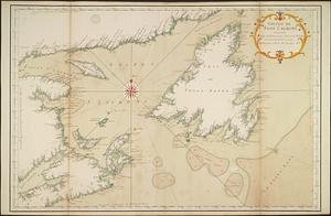
Golphe de Saint Laurent, contenant l'Isle de Terreneuve, Detroit de Belle-Isle, entrée du Fleuve St. Laurent, Isle Royale, et...
27.
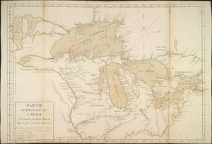
Partie occidentale du Canada contenant les lacs Ontario, Huron, Erié, et Lac Superieur
28.
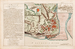
A correct plan of the environs of Quebec, and of the battle fought on the 13th September, 1759 : together with a particular...
29.
A new and accurate map of the English empire in North America : representing their rightful claim as confirm'd by charters, and...
30.
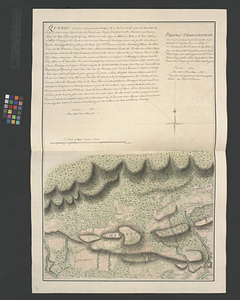
Parish of Charlebourgh
31.
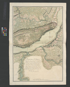
Parish of St. Foix
32.
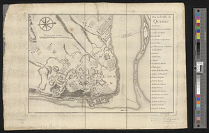
Plan de la ville de Québec
33.
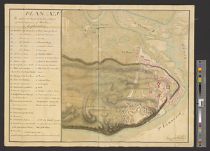
Plan (no. 1) To explain the report of the state of defence of the fortifications of Quebec
34.
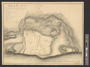
Plan (no. 2) shewing the ground whereon the citadel is proposed to be built : the ground lines of the present fortifications...
35.
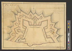
Plan (no. 3) of the citadel compleatly finished
36.
Plan no. 4 shewing the bastion A with its foundations and casemates and bastion B finish'd with its ambrazures and platforms C...
37.
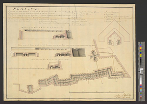
Plan (no. 5) shewing the half bastion C with its foundations and the rampart towards the river side, as far as the loop-hole...
38.
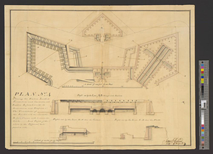
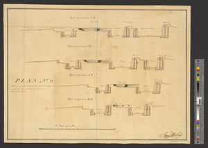
Plan no. 6 shewing the profils cut thro' the different works by the yellow lines seen on plan no. 3
39.
A plan of Quebec
40.
Plan of Québec and the Heights of Abraham, shewing in particular the French encampment after the battle of the 28th: April,...
‹ Prev
Next ›
1
2
3
4
![Carte des découvertes qui ont été faites dans la partie occidentale du Canada sur les mémoires de Mr de la Varanderie [Vérendrye]](https://bpldcassets.blob.core.windows.net/derivatives/images/commonwealth:wp98ck41z/image_thumbnail_300.jpg)