Toggle navigation
LMEC Home
Exhibitions
Georeferencing
Tools for Teachers
Collections
My Favorites
Sign Up / Log In
Search
Search the map portal
Map Collection
Map Collection
Map Sets
Search
Search
Search for
Search In
All Fields
Creator
Title
Subject
Place
Search All Digital Collections
Advanced Search
419 Results
My Search
Start Over
More Like
commonwealth:p8418t63d
Remove constraint More Like: commonwealth:p8418t63d
Filter your Search
Place
North and Central America
412
United States
368
New York
91
Virginia
70
New Jersey
52
York (county)
33
Yorktown
33
South Carolina
31
more
Place
»
Topic
United States--History--Revolution, 1775-1783--Maps
330
Virginia--Maps--Early works to 1800
38
Newport (R.I.)--Maps
24
Yorktown (Va.)--History--Siege, 1781--Maps--Early works to 1800
19
Maryland--Maps--Early works to 1800
18
Charleston (S.C.)--Maps
16
Hudson River (N.Y. and N.J.)--Maps
15
New Jersey--Maps
14
more
Topic
»
Date
Date range begin
–
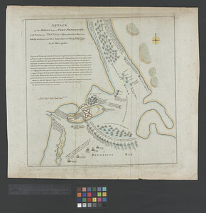
Date range end
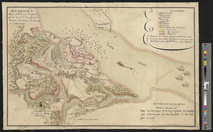
Current results range from
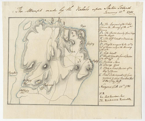
1590
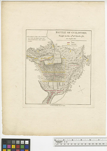
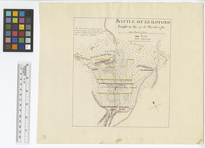
to
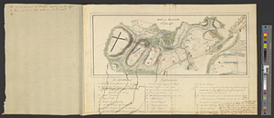
1881
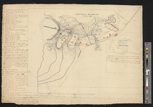
View distribution
Creator
Clinton, Henry, Sir, 1738?-1795
17
Hills, John, active 1777-1819
13
André, John, 1751-1780
11
Faden, William, 1749-1836
11
Montrésor, John, 1736-1799
10
Fage, Edward
9
Castries, Charles Eugène Gabriel de La Croix, marquis de, 1727-1801
8
D'Ethy, captain
8
more
Creator
»
Format
Maps/Atlases
413
Manuscripts
20
Drawings/Illustrations
5
Prints
1
Georeferenced
Yes
6
No
413
Collection
American Revolutionary War-Era Maps
396
William L. Clements Library Collection
305
Norman B. Leventhal Map & Education Center Collection
35
New-York Historical Society Collection
24
Richard H. Brown Revolutionary War Map Collection at Mount Vernon
15
MacLean Collection Map Library
9
Maps from AAS
7
Maritime Charts and Atlases
6
more
Collection
»
Available to use
No known restrictions
58
Creative Commons license
35
Search Constraints
Sort by relevance
relevance
title
date (asc)
date (desc)
Number of results to display per page
20 per page
10
per page
20
per page
50
per page
100
per page
View results as:
grid view
map view
Search Results
61.
Virginia and Maryland
62.
Virginia et Nova Francia
63.
Virginia Marylandia et Carolina in America septentrionali Brittannorum industria excultæ
64.
Virginiae item et Floridae Americae provincarum, nova descriptio
65.
Virginiae item et Floridae Americae provinciarum, nova descriptio
66.
Virginiae partis australis, et Floridae partis orientalis, interjacentiumq[ue] regionum nova descriptio
67.
Virginiae partis australis et Floridae partis orientalis, interjacentium[que] regionum nova descriptio
68.
An accurate map of the United States of America : according to the Treaty of Peace of 1783
69.
Affaire de Monmouth ce 28me Juin 1778
70.
American camp at Valley Forge
71.
Amérique Septentrionale, Yorck : reconnoissance des ouvrages de cette ville ave le tracé des attaques dirigées contre eux
72.
Atlas to Marshall's life of Washington
73.
The attack and defeat of the American fleet under Benedict Arnold, by the kings fleet commanded by Captn. Thos. Pringle, upon...
74.
Attack of the rebels upon Fort Penobscot in the province of New England in which their fleet was totally destroyed and their...
75.
Attaque de la ville d'York en Virginie prise le 19 8bre 1781 par les armées combinées de France et d'Amérique
76.
The attempt made by the rebels upon Staten Island January 15th 1780
77.
Battle of Guildford : fought on the 15th of March 1781
78.
Battle of Guildford fought on the 15 of March 1781
79.
Battle of Monmouth, 28th June 1778
80.
Battle of Monmouth, 28th June 1778
‹ Prev
Next ›
1
2
3
4
5
6
7
8
…
20
21


![Virginiae partis australis, et Floridae partis orientalis, interjacentiumq[ue] regionum nova descriptio](https://bpldcassets.blob.core.windows.net/derivatives/images/commonwealth:st74cw930/image_thumbnail_300.jpg)
![Virginiae partis australis et Floridae partis orientalis, interjacentium[que] regionum nova descriptio](https://bpldcassets.blob.core.windows.net/derivatives/images/commonwealth:6t053p120/image_thumbnail_300.jpg)