Toggle navigation
LMEC Home
Exhibitions
Georeferencing
Tools for Teachers
Collections
My Favorites
Sign Up / Log In
Search
Search the map portal
Map Collection
Map Collection
Map Sets
Search
Search
Search for
Search In
All Fields
Creator
Title
Subject
Place
Search All Digital Collections
Advanced Search
89 Results
My Search
Start Over
More Like
commonwealth:p8418t51m
Remove constraint More Like: commonwealth:p8418t51m
Filter your Search
Place
North and Central America
86
United States
86
New York
71
Manhattan
23
Canada
7
Brooklyn
5
Westchester (county)
5
Fort Washington (historical)
4
more
Place
»
Topic
New York (N.Y.)--Maps
47
New York (N.Y.)--Maps--Early works to 1800
18
Manhattan (New York, N.Y.)--Maps
16
United States--History--Revolution, 1775-1783--Maps
10
Landforms--New York (State)--Maps
6
Rivers--New York (State)--Maps
6
Roads--New York (State)--Maps
6
Brooklyn (New York, N.Y.)--Maps
5
more
Topic
»
Date
Date range begin
–
Date range end
Current results range from
1742
to
1932
View distribution
Creator
Hayward, George, approximately 1800-
4
Ratzer, Bernard
4
Dripps, M. (Matthew)
3
Erskine, Robert, 1735-1780
3
Faden, William, 1749-1836
3
Kitchin, Thomas, 1718-1784
3
Montrésor, John, 1736-1799
3
Pownall, Thomas, 1722-1805
3
more
Creator
»
Format
Maps/Atlases
89
Manuscripts
11
Georeferenced
Yes
9
No
80
Collection
American Revolutionary War-Era Maps
57
Norman B. Leventhal Map Center Collection
36
New-York Historical Society Collection
24
Urban Maps
24
William L. Clements Library Collection
12
Richard H. Brown Revolutionary War Map Collection at Mount Vernon
6
American Antiquarian Society Collection
4
New York Public Library Collection
4
more
Collection
»
Available to use
No known restrictions
60
Creative Commons license
11
Search Constraints
Sort by date (asc)
relevance
title
date (asc)
date (desc)
Number of results to display per page
20 per page
10
per page
20
per page
50
per page
100
per page
View results as:
grid view
map view
Search Results
1.
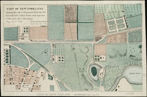
Part of New York in 1742 : showing the site of the present park, the collect and the little collect ponds, and a portion of the...
2.
Particular draughts and plans of some of the principal towns and harbours belonging to the English, French, and Spaniards, in...
3.
A general map of the middle British colonies, in America : viz Virginia, Màriland, Dèlaware, Pensilvania, New-Jersey, New-York,...
4.
A map of the British and French dominions in North America : with the roads, distances, limits, and extent of the settlements,...
5.
A new and accurate map of the English empire in North America : representing their rightful claim as confirm'd by charters, and...
6.
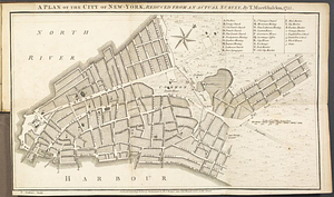
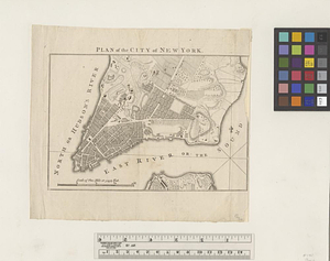
A plan of the City of New York from an actual survey anno domini MDCCLV
7.
Plan of Niagara with the adjacent country surrendered to the English army under the command of Sr. Willm: Johnson Bart: on the...
8.
A plan of the city of New-York, reduced from an actual survey
9.
A south east view of the city of New York, in North America = Vue de sud est de la ville de New York, dans l'Amerique...
10.
A south west view of the city of New York, in North America = Vue de sud ouest de la ville de New York, dans l'Amerique...
11.
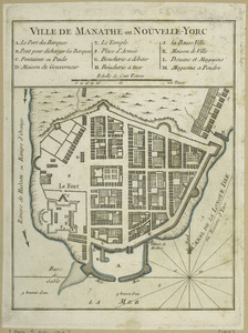
Ville de Manathe ou Nouvelle-Yorc
12.
Ville de Manathe ou Nouvelle-Yorc
13.
To His Excellency Sr. Henry Moore, Bart., captain general and governour in chief in & over the province of New York & the...
14.
PLAN of the CITY of NEW YORK, in North America : Surveyed in the Years 1766 & 1767
15.
Plan de New-York et des environs
16.
Plan of the city of New York
17.
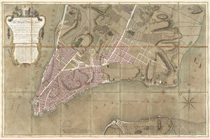
A plan of the city of New-York & its environs to Greenwich, on the North or Hudsons River, and to Crown Point, on the East or...
18.
A plan of the city of New-York & its environs to Greenwich, on the North or Hudsons River, and to Crown Point, on the East or...
19.
The seat of war, in New England, by an American volunteer : with the marches of the several corps sent by the colonies, towards...
20.
An accurate map of Staten Island : with that part of New York, Long Island and the Jerseys, which is the rendesvous of the two...
‹ Prev
Next ›
1
2
3
4
5


![A plan of the city of New-York & its environs to Greenwich, on the North or Hudsons River, and to Crown Point, on the East or Sound River, shewing the several streets, publick buildings, docks, fort & battery, with the true form & course of the commanding grounds, with and without the town : survey'd in the winter, 1775 [i.e. 1766]](https://bpldcassets.blob.core.windows.net/derivatives/images/commonwealth:z603vs09b/image_thumbnail_300.jpg)
![A plan of the city of New-York & its environs to Greenwich, on the North or Hudsons River, and to Crown Point, on the East or Sound River, shewing the several streets, publick buildings, docks, fort & battery, with the true form & course of the commanding grounds, with and without the town : survey'd in the winter, 1775 [i.e. 1766]](https://bpldcassets.blob.core.windows.net/derivatives/images/commonwealth:6t053q479/image_thumbnail_300.jpg)

