Toggle navigation
LMEC Home
Exhibitions
Georeferencing
Tools for Teachers
Collections
My Favorites
Sign Up / Log In
Search
Search the map portal
Map Collection
Map Collection
Map Sets
Search
Search
Search for
Search In
All Fields
Creator
Title
Subject
Place
Search All Digital Collections
Advanced Search
1037 Results
My Search
Start Over
More Like
commonwealth:n8710p94g
Remove constraint More Like: commonwealth:n8710p94g
Filter your Search
Place
North and Central America
1,033
United States
1,023
Suffolk (county)
1,012
Boston
1,011
Massachusetts
140
Roxbury
53
South End
45
Downtown Boston
40
more
Place
»
Topic
Boston (Mass.)--Maps
740
City planning--Massachusetts--Boston--Maps
365
Urban renewal--Massachusetts--Boston--Maps
234
Real property--Massachusetts--Boston--Maps
130
Land use--Massachusetts--Boston--Maps
97
Buildings--Massachusetts--Boston--Maps
84
Landowners--Massachusetts--Boston--Maps
75
Local transit--Massachusetts--Boston--Maps
57
more
Topic
»
Date
Date range begin
–
Date range end
Current results range from
1743
to
2023
View distribution
Creator
Boston Redevelopment Authority
356
Geo. H. Walker & Co
27
Boynton, George W., d. 1884
21
Sampson, Davenport & Co
21
Sampson, Murdock & Co
20
Bromley, George Washington
18
Bromley, Walter Scott
17
Lufkin, Richard F. (Richard Friend)
17
more
Creator
»
Format
Maps/Atlases
1,037
Manuscripts
9
Prints
1
Georeferenced
Yes
100
No
937
Collection
Boston and New England Maps
857
Urban Maps
763
Norman B. Leventhal Map Center Collection
615
Boston Redevelopment Authority Collection
404
American Revolutionary War-Era Maps
25
Mapping Boston Collection
20
Massachusetts Real Estate Atlases
12
William L. Clements Library Collection
10
more
Collection
»
Available to use
No known restrictions
969
Creative Commons license
34
Search Constraints
Sort by date (asc)
relevance
title
date (asc)
date (desc)
Number of results to display per page
20 per page
10
per page
20
per page
50
per page
100
per page
View results as:
grid view
map view
Search Results
1.
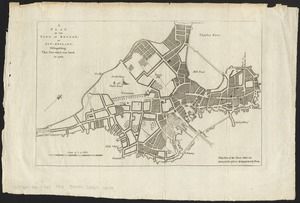
A new plan of ye great town of Boston in New England in America with the many additionall buildings & new streets to the year 1743
2.
Plan de la ville de Boston et ses environs
3.
Plan de Boston : cette ville est composée de quatre mille maisons, et d'environ vingt mille habitans, on compte par an jusqu'a...
4.
Plan de Boston : cette ville est composée de quatre mille maisons, et d'environ vingt mille habitans
5.
A Plan of the town of Boston, in New-England, : distinguishing that part which was burnt in 1760
6.
A plan of the town of Boston, in New-England, distinguishing that part which was burnt in 1760
7.
Boston
8.
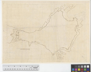
[Chart of Boston Harbor and the surrounding areas]
9.
A draught of the towns of Boston & Charles Town & the circumjacent country, shewing the works thrown up by the kings troops, &...
10.
A map of the coast of New England from Staten Island to the island of Breton
11.
A new and correct plan of the town of Boston
12.
A plan of the town and harbour of Boston. : And the country adjacent with the road from Boston to Concord shewing the place of...
13.
The Seat of war, in New England
14.
To the Hone. Jno. Hancock, Esqre. president of ye Continental Congress, this map of the seat of civil war in America, is...
15.
A plan of the town and chart of the harbour of Boston exhibiting a view of the islands castle forts and entrances into the said...
16.
A plan of the town and harbour of Boston and the country adjacent with the road from Boston to Concord shewing the place of the...
17.
Exact plan of General Gage's lines on Boston Neck in America
18.
A Plan of Boston, and its environs. : Shewing the true situation of His Majesty's army. And also those of the rebels
19.
A plan of Boston in New England with its environs, including Milton, Dorchester, Roxbury, Brooklin, Cambridge, Medford,...
20.
Various plans and draughts of cities, towns, harbours &c. drawn from the latest authorities
‹ Prev
Next ›
1
2
3
4
5
…
51
52


![[Chart of Boston Harbor and the surrounding areas]](https://bpldcassets.blob.core.windows.net/derivatives/images/commonwealth:6108vs71d/image_thumbnail_300.jpg)


