Toggle navigation
LMEC Home
Exhibitions
Georeferencing
Tools for Teachers
Collections
My Favorites
Sign Up / Log In
Search
Search the map portal
Map Collection
Map Collection
Map Sets
Search
Search
Search for
Search In
All Fields
Creator
Title
Subject
Place
Search All Digital Collections
Advanced Search
8931 Results
My Search
Start Over
More Like
commonwealth:js956k42t
Remove constraint More Like: commonwealth:js956k42t
Filter your Search
Place
North and Central America
6,162
United States
5,066
Massachusetts
2,203
Europe
1,396
Suffolk (county)
1,207
Boston
1,180
Canada
450
Asia
438
more
Place
»
Topic
Boston (Mass.)--Maps
752
United States--Maps
282
Massachusetts--Maps
235
Real property--Massachusetts--Boston--Maps
195
City planning--Massachusetts--Boston--Maps
157
Landowners--Massachusetts--Boston--Maps
142
New England--Maps
106
North America--Maps--Early works to 1800
103
more
Topic
»
Date
Date range begin
–
Date range end
Current results range from
1482
to
2023
View distribution
Creator
United States. Hydrographic Office
595
Boston Redevelopment Authority
162
O.H. Bailey & Co
148
Des Barres, Joseph F. W. (Joseph Frederick Wallet), 1722-1824
124
United States. Post Office Dept
120
Ptolemy, 2nd cent
100
Walling, Henry Francis, 1825-1888
95
Geological Survey (U.S.)
92
more
Creator
»
Format
Maps/Atlases
8,870
Manuscripts
217
Prints
56
Books
36
Objects/Artifacts
10
Drawings/Illustrations
8
Posters
5
Ephemera
1
Georeferenced
Yes
893
No
8,038
Collection
Norman B. Leventhal Map & Education Center Collection
8,764
Boston and New England Maps
2,402
Urban Maps
2,143
Maritime Charts and Atlases
1,083
American Revolutionary War-Era Maps
657
Boston Redevelopment Authority Collection
194
Mapping Boston Collection
22
Applied Geographics, Inc. Records
21
more
Collection
»
Available to use
No known restrictions
8,706
Creative Commons license
73
Search Constraints
Sort by relevance
relevance
title
date (asc)
date (desc)
Number of results to display per page
20 per page
10
per page
20
per page
50
per page
100
per page
View results as:
grid view
map view
Search Results
5801.
North America : a working map for illustrating, by coloration, the geographical distribution of life
5802.
North America : British provinces of New Brunswick, Nova Scotia, & part of Canada : compiled from recent surveys and adjusted...
5803.
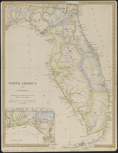
North America : Florida
5804.
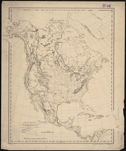
North America
5805.
North America : performed under the patronage of Louis Duke of Orleans, First Prince of the Blood
5806.
North America
5807.
North America : from the French of Mr. d'Anville, improved with the back settlements of Virginia and course of Ohio,...
5808.
North America : corrected from the observation communicated to the Royal Society at London and the Royal Academy at Paris
5809.
North America
5810.
North America
5811.
North America
5812.
North America
5813.
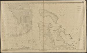
North America, Atlantic coast of the United States, Buzzard's Bay to Cape Lookout : compiled from the latest United States...
5814.
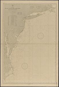
North America, Atlantic coast of the United States, Cape Canaveral to Havana with Straits of Florida and Bahama Banks :...
5815.
North America, Atlantic coast of the United States, Cape Hatteras to Cape Canaveral : compiled from the latest U.S. coast and...
5816.
North America, Atlantic coast of the United States, Halifax to New York with southern part of Nova Scotia : compiled from the...
5817.
North America, Atlantic coast of the United States Halifax to New York with southern part of Nova Scotia : compiled from the...
5818.
North America, Bay of Fundy, Grand Manan Island and adjacent coast : from surveys by the British Admiralty in 1855, and by the...
5819.
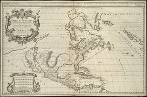
North America divided into its III principall parts : 1st English part viz. English Empire containing ye Articklands near...
5820.
North America, divided into its principall parts where are distinguished the severall states which belong to the English,...
‹ Prev
Next ›
1
2
…
287
288
289
290
291
292
293
294
295
…
446
447