Toggle navigation
LMEC Home
Exhibitions
Georeferencing
Tools for Teachers
Collections
My Favorites
Sign Up / Log In
Search
Search the map portal
Map Collection
Map Collection
Map Sets
Search
Search
Search for
Search In
All Fields
Creator
Title
Subject
Place
Search All Digital Collections
Advanced Search
8714 Results
My Search
Start Over
More Like
commonwealth:js956j819
Remove constraint More Like: commonwealth:js956j819
Filter your Search
Place
North and Central America
5,945
United States
4,859
Massachusetts
2,079
Europe
1,396
Suffolk (county)
1,046
Boston
1,019
Canada
449
Asia
438
more
Place
»
Topic
Boston (Mass.)--Maps
586
United States--Maps
282
Real property--Massachusetts--Boston--Maps
175
Massachusetts--Maps
162
Landowners--Massachusetts--Boston--Maps
133
North America--Maps--Early works to 1800
103
New England--Maps
102
Europe--Maps
79
more
Topic
»
Date
Date range begin
–
Date range end
Current results range from
1482
to
2023
View distribution
Creator
United States. Hydrographic Office
595
O.H. Bailey & Co
148
Des Barres, Joseph F. W. (Joseph Frederick Wallet), 1722-1824
123
United States. Post Office Dept
120
Ptolemy, 2nd cent
100
Walling, Henry Francis, 1825-1888
94
Jefferys, Thomas, -1771
87
Geological Survey (U.S.)
86
more
Creator
»
Format
Maps/Atlases
8,654
Manuscripts
215
Prints
56
Books
36
Objects/Artifacts
10
Drawings/Illustrations
8
Posters
5
Georeferenced
Yes
868
No
7,846
Collection
Norman B. Leventhal Map & Education Center Collection
8,694
Boston and New England Maps
2,233
Urban Maps
2,023
Maritime Charts and Atlases
1,083
American Revolutionary War-Era Maps
636
Boston Redevelopment Authority Collection
87
William L. Clements Library Collection
8
MacLean Collection Map Library
7
more
Collection
»
Available to use
No known restrictions
8,552
Creative Commons license
48
Search Constraints
Sort by relevance
relevance
title
date (asc)
date (desc)
Number of results to display per page
20 per page
10
per page
20
per page
50
per page
100
per page
View results as:
grid view
map view
Search Results
21.
Johnson's new rail road & county copper plate map of the Southern States from the latest and best information
22.
Lloyd's map of the Southern States, showing all the railroads, their stations & distances : also the counties, towns, villages,...
23.
Lloyd's new military map of the border & southern states
24.
Map fourth division railway mail service
25.
Map of the south western part of the United States : constructed and engraved to illustrate "The War with the South"
26.
Map of the Southern States, showing the relative proportion of slaves in the different localities
27.
Map showing the distribution of the slave population of the southern states of the United States
28.
Map third division railway mail service
29.
Military map of the middle and southern states showing the seat of war during the great rebellion in 1861
30.
Perrine's new topographical war map of the southern states : taken from the latest government surveys and official reports
31.
Selected hurricanes affecting the southern United States 1954-1977
32.
Southeast States road map
33.
Southern provinces of the United States
34.
Southern States
35.
The United States southern part : from the latest surveys
36.
Where the fight will be centered, if there is one
37.
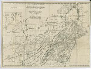
Carte générale des etats de Virginie, Maryland, Delaware, Pensilvanie, Nouveau-Jersey, New-York, Connecticut et Isle de Rhodes...
38.
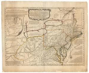
A general map of the middle British colonies, in America; viz Virginia, Maryland, Delaware, Pensilvania, New-Jersey, New-York,...
39.
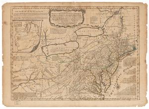
A general map of the Middle British Colonies in America viz. Virginia, Maryland, Delaware, Pensilvania, of Aquanishuonigy the...
40.
A general map of the Middle British Colonies in America viz. Virginia, Maryland, Delaware, Pensilvania, of Aquanishuonigy the...
‹ Prev
Next ›
1
2
3
4
5
6
…
435
436