Toggle navigation
LMEC Home
Exhibitions
Georeferencing
Tools for Teachers
Collections
My Favorites
Sign Up / Log In
Search
Search the map portal
Map Collection
Map Collection
Map Sets
Search
Search
Search for
Search In
All Fields
Creator
Title
Subject
Place
Search All Digital Collections
Advanced Search
8653 Results
My Search
Start Over
More Like
commonwealth:j6735c02s
Remove constraint More Like: commonwealth:j6735c02s
Filter your Search
Place
North and Central America
5,892
United States
4,805
Massachusetts
2,068
Europe
1,392
Suffolk (county)
1,041
Boston
1,014
Canada
449
Asia
437
more
Place
»
Topic
Boston (Mass.)--Maps
582
United States--Maps
279
Real property--Massachusetts--Boston--Maps
175
Massachusetts--Maps
161
Landowners--Massachusetts--Boston--Maps
133
North America--Maps--Early works to 1800
103
New England--Maps
101
Europe--Maps
79
more
Topic
»
Date
Date range begin
–
Date range end
Current results range from
1482
to
2023
View distribution
Creator
United States. Hydrographic Office
594
O.H. Bailey & Co
148
Des Barres, Joseph F. W. (Joseph Frederick Wallet), 1722-1824
123
United States. Post Office Dept
120
Ptolemy, 2nd cent
100
Walling, Henry Francis, 1825-1888
94
Geological Survey (U.S.)
86
Jefferys, Thomas, -1771
85
more
Creator
»
Format
Maps/Atlases
8,593
Manuscripts
215
Prints
56
Books
36
Objects/Artifacts
10
Drawings/Illustrations
8
Posters
5
Georeferenced
Yes
870
No
7,783
Collection
Norman B. Leventhal Map & Education Center Collection
8,646
Boston and New England Maps
2,221
Urban Maps
1,992
Maritime Charts and Atlases
1,082
American Revolutionary War-Era Maps
622
Boston Redevelopment Authority Collection
87
William L. Clements Library Collection
5
American Antiquarian Society Collection
1
more
Collection
»
Available to use
No known restrictions
8,504
Creative Commons license
47
Search Constraints
Sort by relevance
relevance
title
date (asc)
date (desc)
Number of results to display per page
20 per page
10
per page
20
per page
50
per page
100
per page
View results as:
grid view
map view
Search Results
21.
West Indien und Mittel America
22.
Chart of the coast of Honduras and Nicaragua
23.
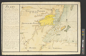
Map of the coast of Hunduras [sic] from the bay of Truxillo to the river Dulcee also the interieur part of that country, from...
24.
Plano de los Tres Rios de Valiz, Nuevo, y Hondo, situados entre et Golfo Dulce o provincia de Goatemala y de la Yucatan en et...
25.
Amérique Septentrionale
26.
Carte geo-hydrographique du Golfe du Mexique et de ces isles : construit d'après les mémoires les plus recens, et assujeties...
27.
Map of the European settlements in South America and on the western coast of Africa
28.
The 100th anniversary map of Abraham Lincoln's visit to Massachusetts, September 11-23, 1848
29.
1630 shoreline
30.
1879. Progress map of the U.S. Geographical Surveys west of the 100th Meridian : prepared under the direction of 1st Lieut....
31.
1903 Map of Salem and surrounding places
32.
19th annual convention of the National Association of Real Estate Boards : at Tulsa, June 7 to June 11 in 1926
33.
2005 significant U.S. hurricane strikes
34.
The 2100 project : an atlas for the Green New Deal
35.
227 Harzgerode
36.
305 Glatz
37.
38,000,000 escaped -- 10,000,000 died
38.
4 Kinten
39.
660 Wakulah St., Roxbury
40.
74 miles on the ocean scenic highway U.S. 1
‹ Prev
Next ›
1
2
3
4
5
6
…
432
433

![Map of the coast of Hunduras [sic] from the bay of Truxillo to the river Dulcee also the interieur part of that country, from the mouth of the river Roman to the city of Comayagua and their principle mines](https://bpldcassets.blob.core.windows.net/derivatives/metadata/commonwealth-oai:rj434386k/image_thumbnail_300.jpg)