Toggle navigation
LMEC Home
Exhibitions
Georeferencing
Tools for Teachers
Collections
My Favorites
Sign Up / Log In
Search
Search the map portal
Map Collection
Map Collection
Map Sets
Search
Search
Search for
Search In
All Fields
Creator
Title
Subject
Place
Search All Digital Collections
Advanced Search
160 Results
My Search
Start Over
More Like
commonwealth:j3860809j
Remove constraint More Like: commonwealth:j3860809j
Filter your Search
Place
North and Central America
102
North America
69
South America
66
Mesoamerica
64
America
57
New England
20
United States
17
Massachusetts
16
more
Place
»
Topic
America--Maps--Early works to 1800
72
Western Hemisphere--Maps--Early works to 1800
58
World maps--Early works to 1800
16
New England--Maps--Early works to 1800
15
North America--Maps--Early works to 1800
12
Massachusetts--Maps
8
Connecticut--Maps--Early works to 1800
5
Massachusetts--Maps--Early works to 1800
5
more
Topic
»
Date
Date range begin
–
Date range end
Current results range from
1482
to
1990
View distribution
Creator
Ortelius, Abraham, 1527-1598
8
Bew, John, -1793
3
Bordon, Benedetto, 1450-1530
3
Danckerts, Justus, 1635-1701
3
Gastaldi, Giacomo, approximately 1500-approximately 1565
3
Hondius, Jodocus, 1594 or 1595-1629
3
L'Isle, Guillaume de, 1675-1726
3
Lodge, John, -1796
3
more
Creator
»
Format
Maps/Atlases
160
Books
1
Georeferenced
Yes
11
No
149
Collection
Sidney R. Knafel Map Collection at Phillips Academy
87
Norman B. Leventhal Map Center Collection
66
American Revolutionary War-Era Maps
37
New York Public Library Collection
5
Mapping Boston Collection
3
Richard H. Brown Revolutionary War Map Collection at Mount Vernon
2
Available to use
No known restrictions
63
Creative Commons license
10
Search Constraints
Sort by relevance
relevance
title
date (asc)
date (desc)
Number of results to display per page
100 per page
10
per page
20
per page
50
per page
100
per page
View results as:
grid view
map view
Search Results
101.
The English pilot. The fourth book. Describing the West-India navigation, from Hudson's-Bay to the River Amazones. Particulary...
102.
Garden of Eden
103.
Generale Ptholemei
104.
Geological map of Massachusetts
105.
The harbor of Holmes' Hole
106.
Herbipolis occidens Wurtzpurg
107.
La heroike enterprinse faict par le Signeur Draeck d'avoir cirquit toute la terre
108.
A map of Massachusetts, from the best authorities
109.
Map of Massachusetts, from the best authorities
110.
A map of New England, New York, New Jersey and Pensilvania
111.
A map of New-England, being the first that ever was here cut, and done by the best pattern that could be had, which being in...
112.
A map of the British and French dominions in North America with the roads, distances, limits, and extent of the settlements,...
113.
Map of the Caribbean Area
114.
Map of the northern, or, New England states of America, comprehending Vermont, New Hampshire, District of Main, Massachusetts,...
115.
Map of the northern part of New England : compiled for Pres't. Dwight's travels
116.
A map of the province of Massachusets Bay and colony of Rhode Island, with part of Connecticut, New Hampshire, and Vermont
117.
Map of the southern part of New England : compiled for Pres't. Dwights travels
118.
Massachusetts
119.
Massachusetts
120.
Massachusetts
121.
Massachusetts and Rhode Island
122.
A new and accurate map of the colony of Massachusets Bay, in North America, from a late survey
123.
A new and accurate map of the present seat of war in North America : from a late survey
124.
New England and New York
125.
New England and New York
126.
New Englands prospect : A true, lively, and experimentall description of that part of America, commonly called New England:...
127.
A new map of the most considerable plantations of the English in America
128.
The north part of America : conteyning Newfoundland, new England, Virginia, Florida, new Spaine, and Noua Francia wth ye rich...
129.
Nouvelle Angleterre et Nouvel York
130.
Nova, et integra universi orbis descriptio
131.
Old Colony & Newport railway and its connections
132.
Old Colony Railroad and connections
133.
Orbis terrae compendiosa descriptio : quam ex magna universali Gerardi Mercatoris Domino Richardo Gartho, geographie ac...
134.
Orbis typus uniuersalis iuxta hydrographorum traditionem
135.
Oval map of the world
136.
Pars Prima. Speculum Nauticum super navigatione maris Occidentalis confectum, continens omnes oras maritimas Gallia, Hispaniae...
137.
Part of east New Jarsey, New York, and Connecticut
138.
Partie de la carte du Capitaine Cluny, auteur d'un ouvrage anglois intitulé American Traveller publié à Londres en 1769
139.
Pascaert van Nieu Nederland van Hendrick Christiaens Eijland tot staten hoeck of Cabo Cod
140.
Pas-caert van Nieu Nederland, Virginia, Nieu Engeland als mede Penn-silvania, met de stad Philadelfia van Baston tot Carrik = a...
141.
Porti della Nuova York e Perthamboy
142.
Praeclara Ferna[n]di Cortesii de Noua maris Oceani Hyspania Narratio . . .
143.
Preliminary sketch showing the positions of Davis' Shoal and other dangers recently discovered by the Coast Survey and the...
144.
Recens edita totius Novi Belgii in America Septentrionali siti
145.
Scandinavia
146.
Secunda etas mundi = Secunda etas mũdi
147.
Septentrionalium terrarum descriptio
148.
Sketch A No. 5 showing proposed site for a light house on Sow and Pigs Reef
149.
Sketch A showing the progress of the survey in section no. 1 from 1844 to 1881
150.
The state of Massachusetts
151.
The state of Massachusetts from the best information
152.
Terra de Lavoratore
153.
Theatro del mondo di Abrahamo Ortelio : da lui poco inanzi la sua morte riueduto, & di tauole nuoue, et commenti adorno, &...
154.
Typus cosmographicus uniuersalis
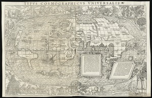
155.
Typus orbis terrarum
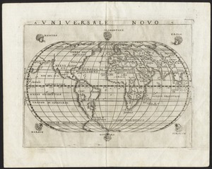
156.
Universale novo
157.
Universalis de terrao orarium ex vera recen [...] traditione
158.
Virginia et Nova Francia
159.
The world
160.
World map
‹ Prev
Next ›
1
2