Toggle navigation
LMEC Home
Exhibitions
Georeferencing
Tools for Teachers
Collections
My Favorites
Sign Up / Log In
Search
Search the map portal
Map Collection
Map Collection
Map Sets
Search
Search
Search for
Search In
All Fields
Creator
Title
Subject
Place
Search All Digital Collections
Advanced Search
614 Results
My Search
Start Over
More Like
commonwealth:hx11z5837
Remove constraint More Like: commonwealth:hx11z5837
Filter your Search
Place
North and Central America
523
United States
247
North America
227
Canada
119
Essex (county)
24
Louisbourg
22
Saint Lawrence River
19
New York
17
more
Place
»
Topic
North America--Maps--Early works to 1800
240
United States--History--French and Indian War, 1754-1763--Maps, Manuscript--Early works to 1800
58
Great Britain--Colonies--America--Maps--Early works to 1800
18
Louisbourg (N.S.)--Maps, Manuscript--Early works to 1800
18
Fort Edward (N.Y.)--Maps, Manuscript--Early works to 1800
16
Fort Ticonderoga (N.Y.)--Maps, Manuscript--Early works to 1800
15
Saint Lawrence River--Maps, Manuscript--Early works to 1800
15
Louisbourg (N.S.)--History--Siege, 1745--Maps, Manuscript--Early works to 1800
14
more
Topic
»
Date
Date range begin
–
Date range end
Current results range from
1528
to
1850
View distribution
Creator
Royal United Services Institute for Defence and Security Studies
160
George, III, King of Great Britain, 1738-1820
152
George, IV, King of Great Britain, 1762-1830
151
Amherst, Jeffery Amherst, Baron, 1717-1797
128
Skinner, Monier
28
Skinner, William, 1700-1780
28
Mitchell, John, 1711-1768
18
Brasier, William
16
more
Creator
»
Format
Maps/Atlases
597
Manuscripts
152
Drawings/Illustrations
15
Georeferenced
Yes
11
No
603
Collection
American Revolutionary War-Era Maps
528
British Library Collection
376
Norman B. Leventhal Map & Education Center Collection
113
MacLean Collection Map Library
59
New York Public Library Collection
32
Boston and New England Maps
21
Richard H. Brown Revolutionary War Map Collection at Mount Vernon
18
Mapping Boston Collection
10
more
Collection
»
Available to use
Creative Commons license
437
No known restrictions
107
Search Constraints
Sort by relevance
relevance
title
date (asc)
date (desc)
Number of results to display per page
20 per page
10
per page
20
per page
50
per page
100
per page
View results as:
grid view
map view
Search Results
561.
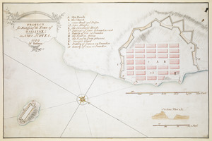
PROJECT for Fortifying the Town of HALLIFAX ; in NOVA SCOTIA
562.
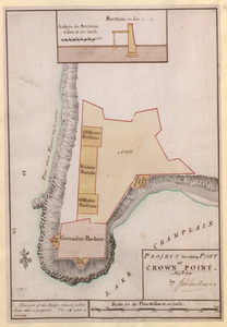
PROJECT for taking POST at CROWN POINT
563.
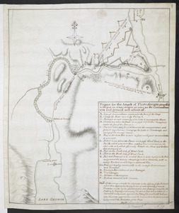
Project for the Attack of Ticonderoga, proposed to be put in executino as near as the circumstances and ground will admit of
564.
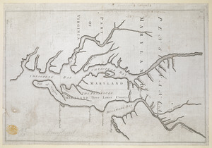
Proposed Maryland / Pennsylvania Boundary
565.
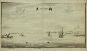
A Prospect of LOUISBOURG taken from ye NE Harbour
566.
The Respective Profiles belonging to the great Iconografical Draughts of Castle Island in the Bay of Boston
567.
THE RIVER S.T LAURENCE
568.
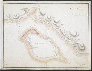
ROAD OF COUDRE
569.
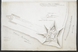
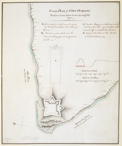
Rough PLAN of FORT DUQUESNE such as it was before it was demolish'd 1758
570.
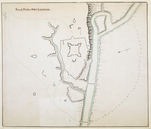
Rough PLAN of FORT LIGONIER
571.
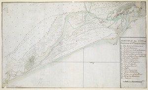
SCETCH of the CITY and Environs of S.T AUGUSTINE
572.
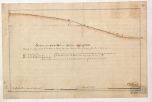
Section of the Citadel-Hill at Halifax : Showing the Progress made by the troops in leveling the same upon the line of 40 feet...
573.
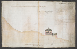
Section taken from the nearest Commanding Ground thro' the Center of the TOWER to High Water Mark
574.
[Six sectional drawings of the Harbour of Saint John, Newfoundland]
575.
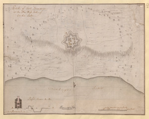
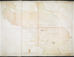
[Sketch map of an unidentified fort]
576.
[Sketch map of the St Lawrence River at River Toniata]
577.
[Sketch map of the St Lawrence River from the Fort de la Présentation to Lake Ontario]
578.
Sketch of Fort Brewerton at the The West End of Onide Lake
579.
A SKETCH of FORT DU QUESNE how it was before the Enemy abandont and distryd it taken from a survey of Cap.t Gordon's
580.
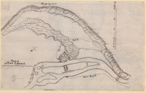
Sketch of Fort Edward and the proposed improvements
‹ Prev
Next ›
1
2
…
25
26
27
28
29
30
31
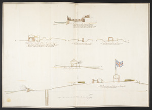
![[Six sectional drawings of the Harbour of Saint John, Newfoundland]](https://bpldcassets.blob.core.windows.net/derivatives/images/commonwealth:6108vv37h/image_thumbnail_300.jpg)
![[Sketch map of an unidentified fort]](https://bpldcassets.blob.core.windows.net/derivatives/images/commonwealth:hx11z101x/image_thumbnail_300.jpg)
![[Sketch map of the St Lawrence River at River Toniata]](https://bpldcassets.blob.core.windows.net/derivatives/images/commonwealth:hx11z103g/image_thumbnail_300.jpg)
![[Sketch map of the St Lawrence River from the Fort de la Présentation to Lake Ontario]](https://bpldcassets.blob.core.windows.net/derivatives/images/commonwealth:hx11z1051/image_thumbnail_300.jpg)