Toggle navigation
LMEC Home
Exhibitions
Georeferencing
Tools for Teachers
Collections
My Favorites
Sign Up / Log In
Search
Search the map portal
Map Collection
Map Collection
Map Sets
Search
Search
Search for
Search In
All Fields
Creator
Title
Subject
Place
Search All Digital Collections
Advanced Search
381 Results
My Search
Start Over
More Like
commonwealth:hx11z2057
Remove constraint More Like: commonwealth:hx11z2057
Filter your Search
Place
North and Central America
341
United States
217
Canada
103
Essex (county)
24
Louisbourg
21
Saint Lawrence River
19
New York
17
Fort Edward
16
more
Place
»
Topic
United States--History--French and Indian War, 1754-1763--Maps, Manuscript--Early works to 1800
57
Louisbourg (N.S.)--Maps, Manuscript--Early works to 1800
18
Fort Edward (N.Y.)--Maps, Manuscript--Early works to 1800
16
Fort Ticonderoga (N.Y.)--Maps, Manuscript--Early works to 1800
15
Saint Lawrence River--Maps, Manuscript--Early works to 1800
15
Louisbourg (N.S.)--History--Siege, 1745--Maps, Manuscript--Early works to 1800
14
New York (State)--Maps, Manuscript--Early works to 1800
14
Fortification--New York (State)--Fort Edward--Maps, Manuscript--Early works to 1800
13
more
Topic
»
Date
Date range begin
–
Date range end
Current results range from
1664
to
1816
View distribution
Creator
Royal United Services Institute for Defence and Security Studies
159
George, III, King of Great Britain, 1738-1820
152
George, IV, King of Great Britain, 1762-1830
151
Amherst, Jeffery Amherst, Baron, 1717-1797
127
Skinner, Monier
28
Skinner, William, 1700-1780
28
Brasier, William
16
Bastide, John Henry, approximately 1700-1770
15
more
Creator
»
Format
Maps/Atlases
363
Manuscripts
155
Drawings/Illustrations
15
Objects/Artifacts
1
Georeferenced
Yes
8
No
373
Collection
British Library Collection
376
American Revolutionary War-Era Maps
357
Boston and New England Maps
21
Library of Congress Collection
5
Urban Maps
5
Maritime Charts and Atlases
2
Available to use
Creative Commons license
381
Search Constraints
Sort by relevance
relevance
title
date (asc)
date (desc)
Number of results to display per page
20 per page
10
per page
20
per page
50
per page
100
per page
View results as:
grid view
map view
Search Results
61.
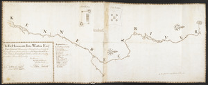
To The Honourable Iohn Winslow Esqr. Major General & Commander in Chief of the Forces Raisd for the Defence of the Eastern...
62.
A map containing part of the Provinces of New York and New Jersey
63.
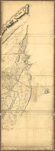
Map of the northern parts of New York
64.
N.W. parts of New York, no. 156
65.
Operations in America : No. 2
66.
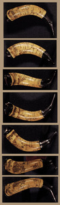
Powder horn with hand-drawn map of the Hudson River (above Albany), Mohawk River, Niagara region, and Lake Ontario in New York...
67.
1.r Plan du fort proposé dans l'Ille de S.t Simon pour la deffence de l'Entree du Havre de Jenkins Sownd
68.
1.r Plan du fort proposé dans l'Ille de S.t Simon pour la deffence de l'Entree du Havre de Jenkins Sownd
69.
1:st Position
70.
2:d Position
71.
2.e Plan d'une Batterie & d'une Redoute avec un Corps de Garde construit en forme de Redoute a Machecoulis pour y Servir de...
72.
3:d Position
73.
4:th Position
74.
[A coloured chart of the upper part of Lake Erie at Fort Erie and a detailed plan of Fort Erie, together with three cross...
75.
A= draught of Boston Harbor
76.
[A manuscript map of Isle Royalle]
77.
[A map of Nova Scotia showing the post roads]
78.
[A map of the east coast of America from Newfoundland to the Bay of Honduras]
79.
[A map of the River Schohary with a plan and elevation of the new fort]
80.
[A map of the southern part of the Lake Champlain, from "Tienderoga fort" to Crown Point]
‹ Prev
Next ›
1
2
3
4
5
6
7
8
…
19
20


![[A coloured chart of the upper part of Lake Erie at Fort Erie and a detailed plan of Fort Erie, together with three cross sectional drawings]](https://bpldcassets.blob.core.windows.net/derivatives/images/commonwealth:hx11z482r/image_thumbnail_300.jpg)

![[A manuscript map of Isle Royalle]](https://bpldcassets.blob.core.windows.net/derivatives/images/commonwealth:hx11z507d/image_thumbnail_300.jpg)
![[A map of Nova Scotia showing the post roads]](https://bpldcassets.blob.core.windows.net/derivatives/images/commonwealth:hx11z494j/image_thumbnail_300.jpg)
![[A map of the east coast of America from Newfoundland to the Bay of Honduras]](https://bpldcassets.blob.core.windows.net/derivatives/images/commonwealth:hx11z584h/image_thumbnail_300.jpg)
![[A map of the River Schohary with a plan and elevation of the new fort]](https://bpldcassets.blob.core.windows.net/derivatives/images/commonwealth:hx11z356x/image_thumbnail_300.jpg)
![[A map of the southern part of the Lake Champlain, from "Tienderoga fort" to Crown Point]](https://bpldcassets.blob.core.windows.net/derivatives/images/commonwealth:6108vv78r/image_thumbnail_300.jpg)