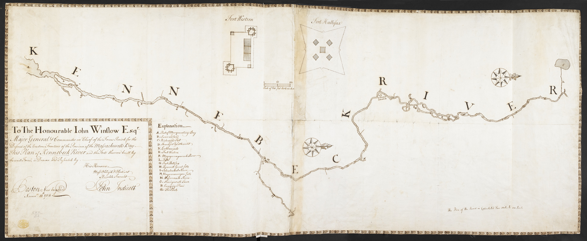
To The Honourable Iohn Winslow Esqr. Major General & Commander in Chief of the Forces Raisd for the Defence of the Eastern Frontiers of the Province of the Massachusetts Bay This Plan of Kennebeck River and the Forts thereon built by the said Forces
This map is also available in American Revolutionary Geographies Online (ARGO), a collections portal especially built for material relating to the American Revolutionary War Era. Visit ARGO to learn more about this item and explore the historical geography of North America in the late eighteenth century.
Item Information
- Title:
- To The Honourable Iohn Winslow Esqr. Major General & Commander in Chief of the Forces Raisd for the Defence of the Eastern Frontiers of the Province of the Massachusetts Bay This Plan of Kennebeck River and the Forts thereon built by the said Forces
- Cartographer:
- Indicott, John
- Former owner:
- George, III, King of Great Britain, 1738-1820
- Donor:
- George, IV, King of Great Britain, 1762-1830
- Dedicatee:
- Winslow, John, 1703-1774
- Name on Item:
-
is drawn and Presented by His Honours Most Oblig'd & Obedient Humble Servant John Indicott.
- Date:
-
1754
- Format:
-
Maps/Atlases
Manuscripts
- Location:
- British Library
- Collection (local):
-
British Library Collection
- Subjects:
-
Fortification--Maine--Kennebec River--Early works to 1800
Kennebec River (Me.)--Maps, Manuscript--Early works to 1800
United States--History--French and Indian War, 1754-1763--Maps, Manuscript--Early works to 1800
Kennebec River (Me.)--Defenses--Early works to 1800
- Places:
-
Kennebec (river)
- Extent:
- 1 map on 2 sheets : joined, manuscript pen and ink with watercolour ; 44 x 113 cm
- Terms of Use:
-
No known copyright restrictions.
This work is licensed for use under a Creative Commons Attribution Non-Commercial Share Alike License (CC BY-NC-SA).

- Scale:
-
Scale 1:126,720
- Language:
-
English
- Catalog Record:
-
http://explore.bl.uk/BLVU1:LSCOP-ALL:BLL01004987815
- Notes:
-
Shows "The Plan of the River is Calculated Two Miles to an Inch" at lower right.
The dedication, title and manuscript imprint appear in a decorative surround at lower left.
Shows a lettered key (A-Q) identifying locations of note along the river.
Shows two inset plans at the top of "Fort Western" (located in present-day Augusta, Maine) and "Fort Hallifax" (located in present-day Winslow, Main) at a "Scale of 120 feet 60 to an Inch" (1:720).
Shows Richmond Fort.
Shows Frankfort (also called Fort Shirley).
Within a decorative border.
Shows a decortive compass rose orienting north to the right of the map.
Titled "A drawn Plan of Kennebeck river, by John Indicott, Nov. 12, 1754. Two sheets" in the Catalogue of Maps, Prints, Drawings, etc., forming the geographical and topographical collection attached to the Library of his late Majesty King George the third, etc., London, 1829.
Titled "A plan of Kennebeck River and the forts thereon, built by the forces raised for the defence of the eastern frontiers of the province of Massachusett's Bay; drawn and inscribed to Major-Gen. John Winslow, Commander-in-chief there, by John Indicott: dated Boston, Nov. 12, 1754; drawn on a scale of 2 miles to an inch; with plans of Fort Western and Fort Hallifax, on a scale of 60 feet to an inch; 3 f. 8 in. x 1 f. 5 in." in the Catalogue of the manuscript maps, charts, and plans, and of the topographical drawings in the British Museum.
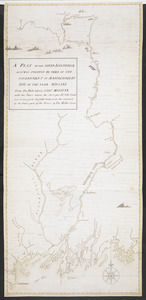
A plan of the River Kennebec extending from Merrymeeting Bay northwards to Embden Pond.

![[A colored map of the route between Albany and Oswego; drawn about 1756, on a scale of 2 miles to an inch]](https://bpldcassets.blob.core.windows.net/derivatives/images/commonwealth:hx11z3223/image_thumbnail_300.jpg)
![[A map of Fort Carillon and environs]](https://bpldcassets.blob.core.windows.net/derivatives/images/commonwealth:hx11z538d/image_thumbnail_300.jpg)
![[A map of Fort Carillon and environs]](https://bpldcassets.blob.core.windows.net/derivatives/images/commonwealth:hx11z342k/image_thumbnail_300.jpg)
