Toggle navigation
LMEC Home
Exhibitions
Georeferencing
Tools for Teachers
Collections
My Favorites
Sign Up / Log In
Search
Search the map portal
Map Collection
Map Collection
Map Sets
Search
Search
Search for
Search In
All Fields
Creator
Title
Subject
Place
Search All Digital Collections
Advanced Search
467 Results
My Search
Start Over
More Like
commonwealth:hx11xz975
Remove constraint More Like: commonwealth:hx11xz975
Filter your Search
Place
North and Central America
426
United States
305
Canada
116
New England
94
Essex (county)
24
Massachusetts
23
New York
23
Saint Lawrence River
23
more
Place
»
Topic
New England--Maps--Early works to 1800
91
United States--History--French and Indian War, 1754-1763--Maps, Manuscript--Early works to 1800
58
Middle Atlantic States--Maps--Early works to 1800
20
Louisbourg (N.S.)--Maps, Manuscript--Early works to 1800
18
Fort Edward (N.Y.)--Maps, Manuscript--Early works to 1800
16
Fort Ticonderoga (N.Y.)--Maps, Manuscript--Early works to 1800
15
Saint Lawrence River--Maps, Manuscript--Early works to 1800
15
Louisbourg (N.S.)--History--Siege, 1745--Maps, Manuscript--Early works to 1800
14
more
Topic
»
Date
Date range begin
–
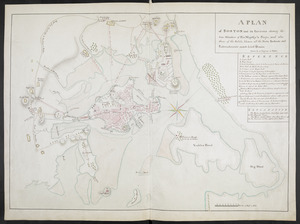
Date range end
Current results range from
1617
to
1999
View distribution
Creator
Royal United Services Institute for Defence and Security Studies
160
George, III, King of Great Britain, 1738-1820
152
George, IV, King of Great Britain, 1762-1830
151
Amherst, Jeffery Amherst, Baron, 1717-1797
130
Skinner, Monier
28
Skinner, William, 1700-1780
28
Brasier, William
16
Bastide, John Henry, approximately 1700-1770
15
more
Creator
»
Format
Maps/Atlases
450
Manuscripts
151
Drawings/Illustrations
15
Georeferenced
Yes
15
No
452
Collection
American Revolutionary War-Era Maps
396
British Library Collection
376
Norman B. Leventhal Map Center Collection
62
Boston and New England Maps
51
Mapping Boston Collection
23
Sidney R. Knafel Map Collection at Phillips Academy
15
Maritime Charts and Atlases
12
Richard H. Brown Revolutionary War Map Collection at Mount Vernon
6
more
Collection
»
Available to use
Creative Commons license
410
No known restrictions
40
Search Constraints
Sort by date (desc)
relevance
title
date (asc)
date (desc)
Number of results to display per page
20 per page
10
per page
20
per page
50
per page
100
per page
View results as:
grid view
map view
Search Results
61.
Bowles's new pocket map of the most inhabited part of New England : comprehending the provinces of Massachusets Bay and New...
62.
Bowles's new pocket map of the most inhabited part of New England : comprehending the provinces of Massachusets Bay and New...
63.
The coast of New England
64.
A map of the most inhabited part of New England, containing the provinces of Massachusets Bay and New Hampshire, with the...
65.
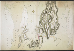
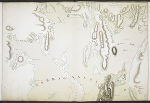
NARRAGANSETT BAY containing Rhode Island &c
66.
NARRAGANSETT BAY containing Rhode Island &c
67.
Partie orientale du Canada, avec la Nouvelle Angleterre, l'Acadie, et la Terre-Neuve
68.
Schauplatz des Kriegs zwischen Engelland und seinen Collonien in America
69.
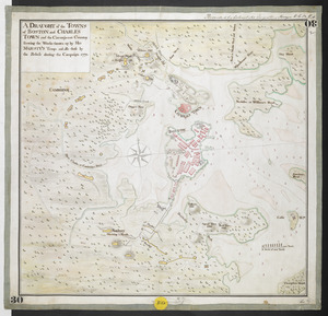
A DRAUGHT of the TOWNS of BOSTON and CHARLES TOWN and the Circumjacent Country shewing the Works thrown up by His MAJESTY'S...
70.
A map of 100 miles round Boston
71.
A MAP of the BRITISH COLONIES in North America : WITH THE Roads, Distances, Limits, and Extent of the SETTLEMENTS, Humbly...
72.
A new and accurate map of the present seat of war in North America : from a late survey
73.
A new map of Nova Scotia and Cape Breton Island : with the adjacent parts of New England and Canada composed from a great...
74.
A PLAN of BOSTON and its Environs shewing the true Situation of His Majesty's Troops, and also those of the Rebels; likewise...
75.
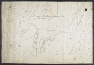
Plan of Ferryland Harbour and Capeling Bay In Newfoundland
76.
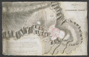
PLAN of PALLISSERS TOWER
77.
The seat of war, in New England, by an American volunteer : with the marches of the several corps sent by the colonies, towards...
78.
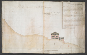
Section taken from the nearest Commanding Ground thro' the Center of the TOWER to High Water Mark
79.
[Six sectional drawings of the Harbour of Saint John, Newfoundland]
80.
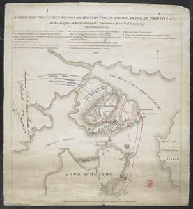
A SKETCH OF THE ACTION BETWEEN THE BRITISH FORCES AND THE AMERICAN PROVINCIALS, on the Heights of the Peninsula of Charlestown,...
‹ Prev
Next ›
1
2
3
4
5
6
7
8
…
23
24


![[Six sectional drawings of the Harbour of Saint John, Newfoundland]](https://bpldcassets.blob.core.windows.net/derivatives/images/commonwealth:6108vv37h/image_thumbnail_300.jpg)