Toggle navigation
LMEC Home
Exhibitions
Georeferencing
Tools for Teachers
Collections
My Favorites
Sign Up / Log In
Search
Search the map portal
Map Collection
Map Collection
Map Sets
Search
Search
Search for
Search In
All Fields
Creator
Title
Subject
Place
Search All Digital Collections
Advanced Search
9123 Results
My Search
Start Over
More Like
commonwealth:ht250q02z
Remove constraint More Like: commonwealth:ht250q02z
Filter your Search
Place
North and Central America
6,354
United States
5,270
Massachusetts
2,193
Suffolk (county)
1,469
Boston
1,442
Europe
1,396
Canada
449
Asia
438
more
Place
»
Topic
Boston (Mass.)--Maps
752
City planning--Massachusetts--Boston--Maps
418
United States--Maps
282
Urban renewal--Massachusetts--Boston--Maps
252
Real property--Massachusetts--Boston--Maps
225
Massachusetts--Maps
166
Landowners--Massachusetts--Boston--Maps
144
New England--Maps
104
more
Topic
»
Date
Date range begin
–
Date range end
Current results range from
1482
to
2023
View distribution
Creator
United States. Hydrographic Office
595
Boston Redevelopment Authority
398
O.H. Bailey & Co
148
Des Barres, Joseph F. W. (Joseph Frederick Wallet), 1722-1824
124
United States. Post Office Dept
120
Ptolemy, 2nd cent
100
Walling, Henry Francis, 1825-1888
94
Geological Survey (U.S.)
87
more
Creator
»
Format
Maps/Atlases
9,063
Manuscripts
215
Prints
56
Books
36
Objects/Artifacts
10
Drawings/Illustrations
8
Posters
5
Georeferenced
Yes
885
No
8,238
Collection
Norman B. Leventhal Map & Education Center Collection
8,723
Boston and New England Maps
2,619
Urban Maps
2,401
Maritime Charts and Atlases
1,083
American Revolutionary War-Era Maps
638
Boston Redevelopment Authority Collection
453
Mapping Boston Collection
20
Massachusetts Real Estate Atlases
12
more
Collection
»
Available to use
No known restrictions
8,926
Creative Commons license
70
Search Constraints
Sort by relevance
relevance
title
date (asc)
date (desc)
Number of results to display per page
20 per page
10
per page
20
per page
50
per page
100
per page
View results as:
grid view
map view
Search Results
6101.
North America--north east coast, north and east coasts of Newfoundland, from Ste. Geneviève Bay to Orange Bay and Strait of...
6102.
North America--west coast, Strait of Juan de Fuca and the channels between the continent & Vancouver Id. showing the boundary...
6103.
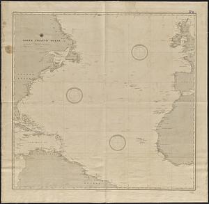
North Atlantic Ocean
6104.
North Atlantic Ocean
6105.
North Atlantic Ocean : compiled from the latest information, 1888
6106.
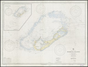
North Atlantic Ocean, Bermuda Islands : from British surveys to 1926, with additions and corrections to 1936
6107.
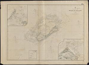
North Atlantic Ocean, Bermuda Islands : from the most recent Brit. Admty. surveys, 1877
6108.
North Atlantic Ocean, eastern portion
6109.
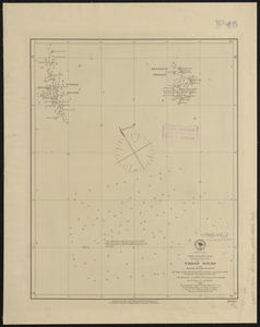
North Atlantic Ocean, Newfoundland Bank, Virgin Rocks and shoals in the vicinity
6110.
North Atlantic Ocean, southeast coast of North America, including the Bahamas and Greater Antilles
6111.
North Atlantic Ocean, w. coast of Africa, Liberia, Cape Mount, the Sugury and Mahfah Rivers and Fisherman's Lake
6112.
North Atlantic Ocean, West Indies
6113.
North Atlantic Ocean, Windward Islands, Guadeloupe and adjacent islands : from a French survey of 1867 to 1869
6114.
North Atlantic track chart
6115.
North Atlantic--Azores, San Miguel : from a British survey in 1844
6116.
North Attleborough, Mass. 1878
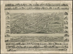
6117.
North Attleborough, Massachusetts : 1891
6118.
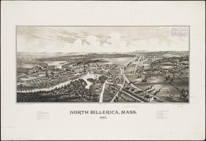
North Billerica, Mass : 1887
6119.
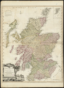
North Britain or Scotland divided into its counties : corrected from the best surveys & astronomical observations
6120.
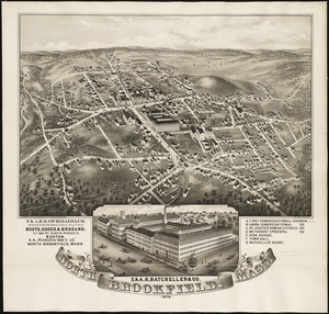
North Brookfield, Mass : 1878
‹ Prev
Next ›
1
2
…
302
303
304
305
306
307
308
309
310
…
456
457