Toggle navigation
LMEC Home
Exhibitions
Georeferencing
Tools for Teachers
Collections
My Favorites
Sign Up / Log In
Search
Search the map portal
Map Collection
Map Collection
Map Sets
Search
Search
Search for
Search In
All Fields
Creator
Title
Subject
Place
Search All Digital Collections
Advanced Search
8388 Results
My Search
Start Over
More Like
commonwealth:ht24zw934
Remove constraint More Like: commonwealth:ht24zw934
Filter your Search
Place
North and Central America
5,137
United States
3,967
Suffolk (county)
1,247
Boston
1,220
Europe
963
Canada
427
Massachusetts
333
France
269
more
Place
»
Topic
Boston (Mass.)--Maps
741
United States--Maps
270
Real property--Massachusetts--Boston--Maps
252
City planning--Massachusetts--Boston--Maps
184
Landowners--Massachusetts--Boston--Maps
169
Massachusetts--Maps
163
North America--Maps--Early works to 1800
103
New England--Maps
101
more
Topic
»
Date
Date range begin
–
Date range end
Current results range from
1482
to
2023
View distribution
Creator
United States. Hydrographic Office
357
Boston Redevelopment Authority
189
O.H. Bailey & Co
148
Des Barres, Joseph F. W. (Joseph Frederick Wallet), 1722-1824
124
United States. Post Office Dept
120
Ptolemy, 2nd cent
100
Walling, Henry Francis, 1825-1888
94
Bromley, George Washington
86
more
Creator
»
Format
Maps/Atlases
8,329
Manuscripts
215
Prints
51
Books
36
Objects/Artifacts
10
Drawings/Illustrations
8
Posters
4
Georeferenced
Yes
885
No
7,503
Collection
Norman B. Leventhal Map Center Collection
8,192
Boston and New England Maps
2,341
Urban Maps
2,076
Maritime Charts and Atlases
750
American Revolutionary War-Era Maps
638
Boston Redevelopment Authority Collection
222
Massachusetts Real Estate Atlases
38
Mapping Boston Collection
20
more
Collection
»
Available to use
No known restrictions
8,166
Creative Commons license
69
Search Constraints
Sort by relevance
relevance
title
date (asc)
date (desc)
Number of results to display per page
100 per page
10
per page
20
per page
50
per page
100
per page
View results as:
grid view
map view
Search Results
1.
Fire insurance district atlas : showing the fire insurance districts of the city of Boston : as established by the State...
2.
Insurance map of Boston : volume 2
3.
Insurance map of Boston : volume 1
4.
Insurance map of Boston : volume 2
5.
Insurance maps of Boston volume one
6.
Insurance maps of Boston volume two
7.
Insurance map of Charlestown : portions of Roxbury (now annexed to Boston) and Cambridge : 1868 : corrected Nov. 1871
8.
Insurance map of Charlestown : portions of Roxbury (now annexed to Boston) and Cambridge
9.
Atlas of the city of Boston : Boston proper : from actual surveys and official plans
10.
Atlas of the city of Boston : Boston proper and Back Bay : from actual surveys and official plans
11.
Atlas of the city of Boston : Boston proper and Back Bay : from actual surveys and official plans
12.
Atlas of the city of Boston : Boston proper and Back Bay : from actual surveys and official plans
13.
Atlas of the city of Boston : Boston proper and Back Bay : from actual surveys and official plans
14.
Atlas of the city of Boston : Boston proper and Back Bay : from actual surveys and official plans
15.
Atlas of the city of Boston : Boston proper and Back Bay : from actual surveys and official plans
16.
Atlas of the city of Boston : Boston proper and Back Bay : from actual surveys and official plans
17.
Atlas of the city of Boston : Boston proper and Roxbury : from actual surveys and official plans
18.
Atlas of the city of Boston : city proper : volume 1 : from actual surveys and official records
19.
Atlas of the city of Boston : city proper and Roxbury : from actual surveys and official plans
20.
Atlas of the city of Boston : city proper, volume one : from actual surveys and official plans
21.
Atlas of the city of Boston : city proper, volume two : from actual surveys and official plans
22.
Atlas of the city of Boston : Roxbury : from actual surveys and official plans
23.
Atlas of the county of Suffolk, Massachusetts : vol. 1st including Boston proper : from actual surveys and official records
24.
Campus High School urban renewal area Mass. r-129 : property map
25.
City atlas of Boston, Massachusetts : complete in one volume : from official records, private plans and actual surveys
26.
City of Boston : topographic and planimetric survey
27.
Map of Boston and its vicinity from actual survey
28.
[Map of Scollay Square and vicinity]
29.
Map of the city of Boston : from the recent surveys of the city and dist. surveyors, and from official records and actual surveys
30.
Map of the city of Boston and its environs
31.
A map plat or draught of the twelve divisions of land as they were laid out, bounded & measured to ye proprietors in...
32.
Old Boston, compiled from the Book of possessions
33.
Peremptory sale : this valuable property will positively be sold at public auction on Saturday the 29th day of April current at...
34.
A plan of 8 lots of city land known as the Arsenal Lot : and 7 lots fronting on Providence St. to be sold at auction, on...
35.
Plan of a portion of the properties of the Long Wharf or Boston Pier & Central Wharf & Wet Dock Corporatins, showing sixteen...
36.
Plan of an estate belonging to the City of Boston to be sold by public auction on Wednesday, Sept. 14th, 1881 ... : per order...
37.
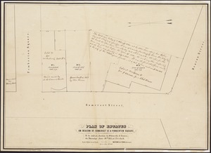
Plan of building lots on Phillips Place, Tremont & Somerset Streets
38.
Plan of building lots on Phillips Place, Tremont & Somerset Streets
39.
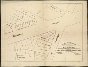
Plan of building lots on Washington, Waltham & Parker Streets and Harrison Avenue, belonging to the Boston Lying-In Hospital...
40.
Plan of Church St. district, showing estates and buildings : as proposed to be taken by the city of Boston under the Act of the...
41.
Plan of city lands to be sold Oct. 30th 1850
42.
Plan of City Wharf in Boston, Mass : shewing 14 lots of land on the side of the south dock of said wharf & Commercial St. : to...
43.
Plan of estate, nos 1043 to 1059 Washington Street, Boston, belonging to the heirs of the late William Brigham : to be sold by...
44.
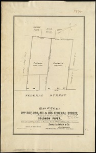
Plan of estate nos 207, 209, 211 & 215 Federal Street, belonging to the estate of the late Solomon Piper : to be sold at public...
45.
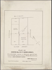
Plan of estates nos. 13-17 Oliver Street, to be sold by public auction on Wednesday April 12th 1871 at 12 o'clock m. on the...
46.
Plan of estates on Beacon St., Somerset St. & Pemberton Square : to be sold at auction by Whitwells & Seaver, on Thursday June...
47.
Plan of estates on Suffolk St. District : belonging to the City of Boston : to be sold at public auction, Dec. 23rd 1871
48.
Plan of Fort Hill showing street improvements as adopted by the city council : 1869
49.
Plan of Gray's Wharf, to be sold at public auction, on the premises, on Thursday April 28th 1870 at 12 o'clock noon
50.
Plan of land & wharves belonging to Mill Pond Wharf Co. near Bartons Point
51.
Plan of land on Bedford and Avon Streets belonging to the proprietors of the Second Church in Boston : to be sold by public...
52.
Plan of lands belonging to the Commonwealth of Massachusetts
53.
Plan of lands on the Back Bay belonging to the Boston Water Power Co., the Commonwealth and other parthies [i.e. parties],...
54.
[Plan of lots between Mount Vernon and Pinckney Streets in Boston]
55.
[Plan of lots for sale on Morton and Milk Streets, Boston]
56.
[Plan of lots for sale on Pearl Street in Boston]
57.
[Plan of lots in Chinatown (Boston), between Avery and Eliot Streets, and Tremont Street and Harrison Avenue]
58.
[Plan of lots in South Boston]
59.
[Plan of lots on Beacon Street and Somerset Court, Boston]
60.
Plan of lots on Fort Hill district, belonging to the City of Boston : to be sold at public auction, on Wednesday, April 15th at...
61.
[Plan of lots on Park, Beacon and Tremont Streets in Boston]
62.
Plan of Mercantile Wharf property in Boston Mass : showing 5 lots of land thereon to be sold at public auction on Tuesday April...
63.
[Plan of part of Boston bounded by Eliot, Washington, and Pleasant streets showing landownership in the late 17th century]
64.
Plan of Public library lot
65.
Plan of Quincy House lot, corner of Brattle St. and Brattle Sq. belonging to the estate of Josiah Quincy Jr : to be sold by...
66.
Plan of real estate on Cambridge Street near Bowdoin Square, belonging to the heirs of the late Deacon Moses : to be sold by...
67.
[Plan of real estate on Pearl Street, Boston]
68.
Plan of site for new court house on Pemberton Sq. and Somerset St. for the County of Suffolk : taken by authority of Chapter 377
69.
Plan of store lots near Haymarket Square : belonging to the estate of Josiah Quincy Jr. : to be sold by public auction on...
70.
Plan of the Brooks estate corner of Court & Washington Street : to be sold at public auction, at the Merchants Exchange Reading...
71.
Plan of the city of Boston
72.
Plan of the Coffin Estate, corner of Summer and Chauncy Streets : to be sold by public auction on Wednesday April 26th 1856 at...
73.
Plan of the estate on the southerly corner of Washington and Franklin Streets : to be sold by public auction on Saturday June...
74.
Plan of the estates nos. 246 to 252 Congress corner of Purchase Street and nos. 59 to 69 Purchase Street : to be sold by public...
75.
Plan of the Federal St. Meeting House estate : to be sold by public auction, on Thursday February 24th 1859, at 12 o'clock noon...
76.
[Plan of the Gore Estate at the corner of Pitts and Green streets]
77.
Plan of the Hutchinson Estate on the corner of Hanover & Clark Streets : to be sold by public auction on Monday Feby. 20th 1871...
78.
Plan of the old Julien estate : compriseing [sic] two stores on Milk and Congress Streets : belonging to the estate of the late...
79.
Plan of the Pratt estate, corner of Summer & Hawley Streets : to be sold by pulic auction on Thursday April 10th 1855 at 12...
80.
Plan of the South Cove
81.
Plan of two lots of valuable land in Washington Village, South Boston : to be sold at Public Auction, on Wednesday April 22d...
82.
A rough and inaccurate sketch of the streets of Boston as they are supposed to have been first laid out & the owners of the...
83.
Atlas of the city of Boston : Boston proper and Back Bay
84.
Atlas of the city of Boston : Boston proper and Back Bay
85.
Atlas of the city of Boston : Boston proper and Roxbury
86.
Atlas of the city of Boston : Boston proper
87.
Atlas of the city of Boston : Boston proper and Back Bay
88.
Atlas of the city of Boston : Boston proper and Back Bay
89.
Atlas of the city of Boston : Boston proper and Back Bay
90.
Atlas of the county of Suffolk, Massachusetts, vol. 1 : including Boston proper
91.
Central business district urban renewal area Massachusetts r-82 : acquisition plan
92.
Central business district urban renewal area Massachusetts r-82 : property map
93.
Downtown waterfront-Faneuil Hall urban area Massachusetts R-77 : existing and proposed zoning
94.
Downtown waterfront-Faneuil Hall urban area Massachusetts R-77 : proposed land use
95.
Downtown waterfront-Faneuil Hall urban renewal area Massachusetts R-77 : property
96.
Downtown waterfront-Faneuil Hall urban renewal area Massachusetts R-77 : property
97.
Park Plaza urban renewal area : environmental deficiencies and blighting influences map
98.
Park Plaza urban renewal area : map no. 5 ownership data map
99.
Park Plaza urban renewal area : map no. 6 land disposal map
100.
Plans of estates of William C. Barstow
‹ Prev
Next ›
1
2
3
4
5
…
83
84


![[Map of Scollay Square and vicinity]](https://bpldcassets.blob.core.windows.net/derivatives/images/commonwealth:x059cc25q/image_thumbnail_300.jpg)


![Plan of lands on the Back Bay belonging to the Boston Water Power Co., the Commonwealth and other parthies [i.e. parties], showing the system of streets, grades and sewers as laid out and recommended by the Back Bay Commissioners](https://bpldcassets.blob.core.windows.net/derivatives/images/commonwealth:1257bb305/image_thumbnail_300.jpg)
![[Plan of lots between Mount Vernon and Pinckney Streets in Boston]](https://bpldcassets.blob.core.windows.net/derivatives/images/commonwealth:9s161h42m/image_thumbnail_300.jpg)
![[Plan of lots for sale on Morton and Milk Streets, Boston]](https://bpldcassets.blob.core.windows.net/derivatives/images/commonwealth:9s161h52v/image_thumbnail_300.jpg)
![[Plan of lots for sale on Pearl Street in Boston]](https://bpldcassets.blob.core.windows.net/derivatives/images/commonwealth:9s161h54d/image_thumbnail_300.jpg)
![[Plan of lots in Chinatown (Boston), between Avery and Eliot Streets, and Tremont Street and Harrison Avenue]](https://bpldcassets.blob.core.windows.net/derivatives/images/commonwealth:cj82kz565/image_thumbnail_300.jpg)
![[Plan of lots in South Boston]](https://bpldcassets.blob.core.windows.net/derivatives/images/commonwealth:9s161h046/image_thumbnail_300.jpg)
![[Plan of lots on Beacon Street and Somerset Court, Boston]](https://bpldcassets.blob.core.windows.net/derivatives/images/commonwealth:9s161h18j/image_thumbnail_300.jpg)

![[Plan of lots on Park, Beacon and Tremont Streets in Boston]](https://bpldcassets.blob.core.windows.net/derivatives/images/commonwealth:9s161j64v/image_thumbnail_300.jpg)

![[Plan of part of Boston bounded by Eliot, Washington, and Pleasant streets showing landownership in the late 17th century]](https://bpldcassets.blob.core.windows.net/derivatives/images/commonwealth:4m90fp141/image_thumbnail_300.jpg)


![[Plan of real estate on Pearl Street, Boston]](https://bpldcassets.blob.core.windows.net/derivatives/images/commonwealth:9s161d705/image_thumbnail_300.jpg)


![[Plan of the Gore Estate at the corner of Pitts and Green streets]](https://bpldcassets.blob.core.windows.net/derivatives/images/commonwealth:9s161h402/image_thumbnail_300.jpg)


