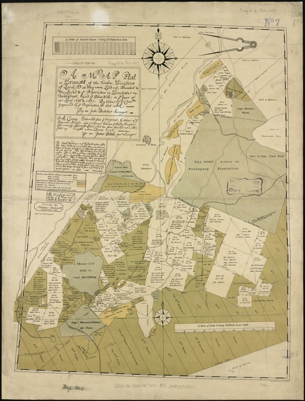
A map plat or draught of the twelve divisions of land as they were laid out, bounded & measured to ye proprietors in Dorchester, new grant, beyond ye Blew-Hills, in ye years of our Lord 1696 & 1697
Item Information
- Title:
- A map plat or draught of the twelve divisions of land as they were laid out, bounded & measured to ye proprietors in Dorchester, new grant, beyond ye Blew-Hills, in ye years of our Lord 1696 & 1697
- Title (alt.):
-
Copy extracted from ye original, by order of ye proprietors abovesaid, and ye vacances between ye twelve division lots, commonly called wast-land (which has since been laid out or sold) filled up
- Creator:
- Butcher, John.
- Name on Item:
-
by order of ye comtee. impowred by ye proprietors for that work ; by me John Butcher, surveyor.
- Date:
-
1891
- Format:
-
Maps/Atlases
- Location:
-
Boston Public Library
Norman B. Leventhal Map & Education Center - Collection (local):
-
Norman B. Leventhal Map & Education Center Collection
- Subjects:
-
Real property--Massachusetts--Boston--Maps
Land tenure--Massachusetts--Boston--Maps
Boston (Mass.)--Maps
Dorchester (Boston, Mass.)--Maps
- Places:
-
MassachusettsSuffolk (county)BostonDorchester
- Extent:
- 1 plan : col. ; 56 x 44 cm.
- Terms of Use:
-
No known copyright restrictions.
No known restrictions on use.
- Publisher:
-
S.l :
[s.n.]
- Scale:
-
Scale not given.
- Language:
-
English
- Notes:
-
Copied by Frederic Endicott February, 1891.
"Heliotype Printing Co., Boston."
- Identifier:
-
06_01_003791
- Call #:
-
G3764.B6:2D6G46 1697 .B97
- Barcode:
-
39999059002111

![[Plan of house lots for sale on Savin Hill Avenue, Dorchester, Mass.]](https://bpldcassets.blob.core.windows.net/derivatives/images/commonwealth:9s161f68b/image_thumbnail_300.jpg)


