Campus High School urban renewal area Mass. r-129 : property map
Item Information
- Title:
- Campus High School urban renewal area Mass. r-129 : property map
- Cartographer:
- Boston Redevelopment Authority
- Name on Item:
-
Boston Redevelopment Authority ; drawn by Dan Herlihy
- Date:
-
1971
- Format:
-
Maps/Atlases
- Location:
-
Boston Public Library
Norman B. Leventhal Map & Education Center - Collection (local):
-
Norman B. Leventhal Map & Education Center Collection
- Series:
- Boston Redevelopment Authority Maps & Manuscript Plans Collection
- Subjects:
-
Roxbury (Boston, Mass.)--Maps
Boston (Mass.)--Maps
City planning--Massachusetts--Boston--Maps
Real property--Massachusetts--Boston--Maps
Landowners--Massachusetts--Boston--Maps
Urban renewal--Massachusetts--Boston--Maps
- Places:
-
MassachusettsSuffolk (county)BostonRoxbury
- Extent:
- 1 map photocopy ; 88 x 66 cm, on sheet 108 x 137 cm
- Terms of Use:
-
No known copyright restrictions.
No known restrictions on use.
- Publisher:
-
[Boston] :
Boston Redevelopment Authority
- Scale:
-
Scale 1:480. 1 inch = 40 feet
- Language:
-
English
- Notes:
-
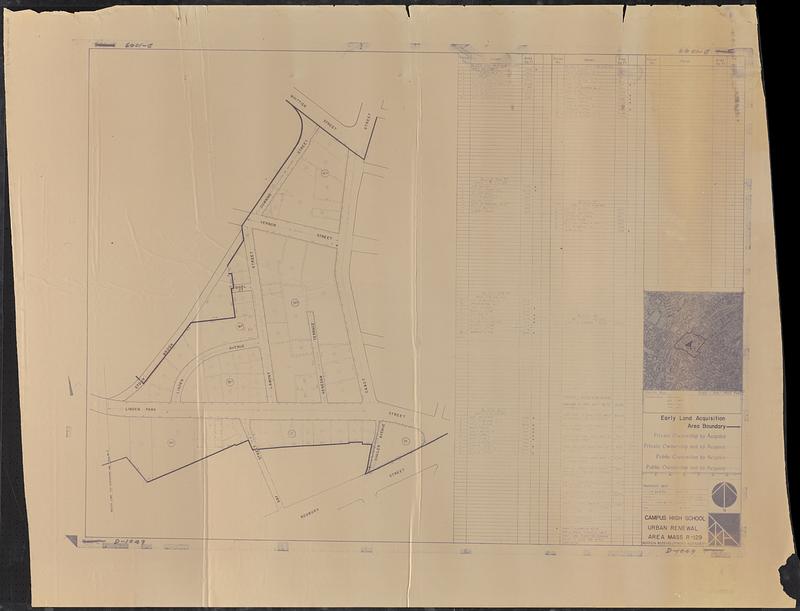
Shows parcels, early land acquisition area boundary, private ownership to acquire, private ownership not to acquire, public ownership to acquire, and public ownership not to acquire.
Includes vicinity map and table listing parcel no., owner, and area.
"Corrections ... Jan, 1971."
"D-1049."
- Identifier:
-
06_01_018568
- Call #:
-
BRA MAP FOLDER 52 no.4
- Barcode:
-
30000008307630


