Toggle navigation
LMEC Home
Exhibitions
Georeferencing
Tools for Teachers
Collections
My Favorites
Sign Up / Log In
Search
Search the map portal
Map Collection
Map Collection
Map Sets
Search
Search
Search for
Search In
All Fields
Creator
Title
Subject
Place
Search All Digital Collections
Advanced Search
304 Results
My Search
Start Over
More Like
commonwealth:hq37vv88v
Remove constraint More Like: commonwealth:hq37vv88v
Filter your Search
Place
North and Central America
261
United States
248
New England
140
Maine
55
Massachusetts
37
New York
36
New Hampshire
32
Vermont
29
more
Place
»
Topic
New England--Maps
127
Maine--Maps
55
Railroads--New England--Maps
50
New Hampshire--Maps
32
Vermont--Maps
29
New York (State)--Maps
27
Massachusetts--Maps
24
New England--Maps--Early works to 1800
15
more
Topic
»
Date
Date range begin
–
Date range end
Current results range from
1482
to
2015
View distribution
Creator
United States. Post Office Dept
9
Carey, Mathew, 1760-1839
8
Carleton, Osgood, 1742-1816
8
Geological Survey (U.S.)
6
Doolittle, Amos, 1754-1832
5
National Publishing Company (Boston, Mass.)
5
Norman, John, 1748?-1817
5
Ortelius, Abraham, 1527-1598
5
more
Creator
»
Format
Maps/Atlases
304
Manuscripts
4
Books
1
Objects/Artifacts
1
Georeferenced
Yes
32
No
272
Collection
Norman B. Leventhal Map & Education Center Collection
168
Boston and New England Maps
127
Sidney R. Knafel Map Collection at Phillips Academy
87
American Revolutionary War-Era Maps
74
Maps from AAS
25
William L. Clements Library Collection
15
MacLean Collection Map Library
6
David Judkins Weaver Papers
5
more
Collection
»
Available to use
No known restrictions
168
Creative Commons license
3
Search Constraints
Sort by relevance
relevance
title
date (asc)
date (desc)
Number of results to display per page
20 per page
10
per page
20
per page
50
per page
100
per page
View results as:
grid view
map view
Search Results
81.
New commercial, sportsmen's and route survey of Maine : showing all postoffices, railroads, electric roads, principal highways,...
82.
A new map of Maine
83.
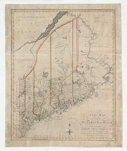
A new map of the District of Maine : taken from the original map compiled by Osgood Carleton Esqr. : From the actual surveys...
84.
A new map of the district of Maine taken from the original map compiled by Osgood Carleton esqr. from the actual surveys that...
85.
North America : British provinces of New Brunswick, Nova Scotia, & part of Canada : compiled from recent surveys and adjusted...
86.
A plan of a rout from Fort Pownall on the river Penobscot in New England to Quebec and from Quebec to Fort Pownall : taken by...
87.
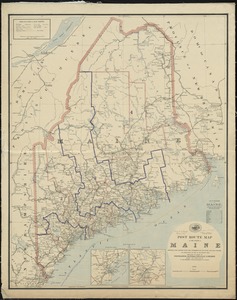
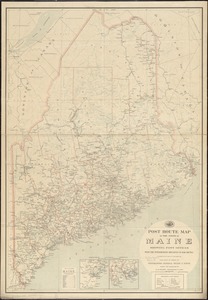
Post route map of the State of Maine showing post offices with the intermediate distances and mail routes in operation on the...
88.
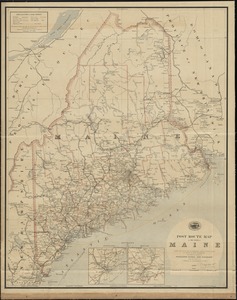
Post route map of the State of Maine showing post offices with the intermediate distances and mail routes in operation on the...
89.
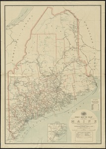
Post route map of the state of Maine showing post offices with the intermediate distances on mail routes in operation on the...
90.
Post route map of the state of Maine showing post offices with the intermediate distances on mail routes in operation on the...
91.
Province of Maine
92.
The province of Maine, from the best authorities
93.
The Province of Maine, from the best authorities 1795
94.
Route and pictorial map of Maine
95.
Sketch of different passes into Canada from our lower provinces
96.
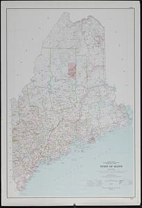
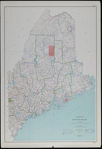
State of Maine
97.
State of Maine
98.
State of Maine
99.
State of Maine : base map with highways and contours
100.
State of Maine : base map with highways and contours
‹ Prev
Next ›
1
2
3
4
5
6
7
8
9
…
15
16