Toggle navigation
LMEC Home
Exhibitions
Georeferencing
Tools for Teachers
Collections
My Favorites
Sign Up / Log In
Search
Search the map portal
Map Collection
Map Collection
Map Sets
Search
Search
Search for
Search In
All Fields
Creator
Title
Subject
Place
Search All Digital Collections
Advanced Search
395 Results
My Search
Start Over
More Like
commonwealth:h989xm80h
Remove constraint More Like: commonwealth:h989xm80h
Filter your Search
Place
North and Central America
343
United States
216
North America
73
Canada
63
New York
24
Pennsylvania
19
Asia
17
Great Lakes Region
16
more
Place
»
Topic
North America--Maps--Early works to 1800
64
United States--Maps--Early works to 1800
44
Canada--Maps--Early works to 1800
42
Great Lakes Region (North America)--Maps--Early works to 1800
17
Indians of North America--Maps--Early works to 1800
14
Pennsylvania--Maps--Early works to 1800
12
Northeastern States--Maps--Early works to 1800
10
New York (State)--Maps--Early works to 1800
9
more
Topic
»
Date
Date range begin
–
Date range end
Current results range from
1623
to
1999
View distribution
Creator
Jefferys, Thomas, -1771
20
Bellin, Jacques Nicolas, 1703-1772
15
Gibson, J. (John), active 1750-1792
14
Robert Sayer and John Bennett (Firm)
14
Carleton, Osgood, 1742-1816
13
Faden, William, 1749-1836
13
Sayer, Robert, 1725-1794
12
Bowles, Carington, 1724-1793
10
more
Creator
»
Format
Maps/Atlases
393
Manuscripts
5
Paintings
3
Ephemera
1
Objects/Artifacts
1
Prints
1
Georeferenced
Yes
1
No
394
Collection
MacLean Collection Map Library
379
American Revolutionary War-Era Maps
339
Norman B. Leventhal Map & Education Center Collection
7
Richard H. Brown Revolutionary War Map Collection at Mount Vernon
4
Newberry Library Collection
2
Mapping Boston Collection
1
Massachusetts Historical Society Map Collection
1
New York Public Library Collection
1
more
Collection
»
Available to use
Creative Commons license
7
No known restrictions
7
Search Constraints
Sort by relevance
relevance
title
date (asc)
date (desc)
Number of results to display per page
20 per page
10
per page
20
per page
50
per page
100
per page
View results as:
grid view
map view
Search Results
321.
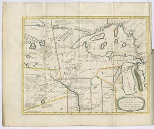
A plan of Captain Carvers travels in the interior parts of North America in 1776 and 1767
322.
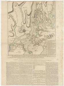
A plan of New York Island, with part of Long Island, Staten Island & east New Jersey, with a particular description of the...
323.
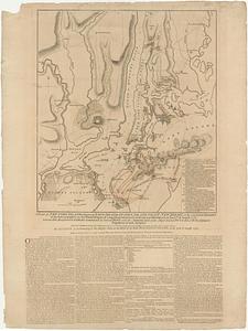
A plan of New York Island, with part of Long Island, Staten Island & east New Jersey, with a particular description of the...
324.
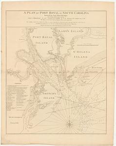
A plan of Port Royal in South Carolina
325.
A plan of Quebec
326.
A plan of Quebec
327.
A plan of Quebec and environs : with its defences and the occasional entrenched camps of the French, commanded by Marquis de...
328.
A plan of the attack of Fort Sulivan, near Charles Town in South Carolina, by a squadron of His Majesty's ships, on the 28.th...
329.
Plan of the city and environs of Quebec, with its siege and blockade by the Americans, from the 8.th of December 1775 to the...
330.
A plan of the city of Albany surveyed at the request of the Mayor Aldermen and commonalty
331.
Plan of the city of Philadelphia
332.
A plan of the city of Philadelphia, the capital of Pennsylvania, from an actual survey
333.
A plan of the city of Quebec the capital of Canada : as it surrender'd 18 Septemb.r 1759 to the British fleet and army ;...
334.
Plan of the harbour and settlement of Pensacola
335.
A plan of the harbour of S.t Augustin in the province of Georgia
336.
A plan of the island of S.t John with the divisions of the counties parishes & the lots as granted by government likewise the...
337.
Plan of the mil.y reservation at Detroit
338.
A plan of the posts of York and Gloucester in the province of Virginia, established by His Majesty's army under the command of...
339.
A plan of the town, bar, harbour and environs, of Charlestown in South Carolina, with all the channels, soundings,...
340.
Plan of the town of Erie on Lake Erie
‹ Prev
Next ›
1
2
…
13
14
15
16
17
18
19
20